Carquinez Strait facts for kids
Quick facts for kids Carquinez Strait |
|
|---|---|

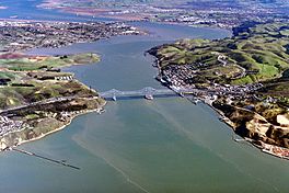
Looking east, the Carquinez Bridge in the foreground and the Benicia–Martinez Bridge in the background
|
|
| Location | Bay Area, Northern California |
| Coordinates | 38°03′33″N 122°12′45″W / 38.05918°N 122.21260°W |
| River sources | Sacramento River, San Joaquin River |
| Primary outflows | San Pablo Bay, San Francisco Bay |
| Basin countries | United States |
| Max. length | 8 miles (13 km) |
| Settlements | Benicia, Crockett, Martinez, Vallejo |
The Carquinez Strait is a narrow waterway in Northern California. It's like a natural channel that connects different parts of the water system. This strait is part of a larger estuary where the Sacramento River and San Joaquin River meet the ocean.
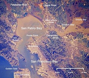
It's about 8 miles (13 km) long. The strait links Suisun Bay (where the rivers first meet) with San Pablo Bay. San Pablo Bay is a northern part of the much larger San Francisco Bay.
The Carquinez Strait was formed a very long time ago. This happened near the end of one of Earth's past ice ages. Back then, a huge lake covered what is now the Sacramento and San Joaquin valleys. As ice melted from the Sierra Nevada mountains, the lake's water level rose. At the same time, earthquakes and other ground movements created a new path to the Pacific Ocean. This new path drained the giant lake, revealing the valleys we see today.
Contents
How the Strait Was Formed
Scientists believe the Carquinez Strait likely formed between 640,000 and 700,000 years ago. This was when much of California was coming out of an ice age. The areas that are now the Sacramento Valley and San Joaquin Valley were once covered by a massive ancient lake. This lake is known as Lake Corcoran.
At first, Lake Corcoran drained into the ocean near present-day Monterey. But over time, earthquakes caused the coastal mountains to rise. This blocked the lake's original outlet. Meanwhile, melting ice from the Sierra Nevada mountains kept adding water to Lake Corcoran. Eventually, the lake water became so high that it started to carve a new path to the ocean.
At some point, the land barrier between where the cities of Crockett and Benicia are today broke open. This released the lake water in a huge, powerful flood. This event created the Carquinez Strait as we know it.
Where is the Carquinez Strait?
The strait forms part of the boundary between two counties: Solano County to the north and Contra Costa County to the south. It's about 15 miles (25 km) north of Oakland.
On the north side of the strait, you'll find the cities of Benicia and Vallejo. On the southern side are Martinez, Port Costa, and Crockett. The Napa River also connects to the strait through a smaller channel called the Mare Island Strait. The entire area that drains into the Carquinez Strait is huge, covering about 62,500 square miles (161,875 km²). This is about 40 percent of California's total land area!
What Does "Carquinez" Mean?
The name "Carquinez Strait" comes from the Karkin people. They were a group of Ohlone Native Americans. They lived on both sides of the strait a long time ago. In Spanish, they were called los Carquines.
Important Places Along the Strait
You can find some interesting places along the Carquinez Strait. The California Maritime Academy is located on the northern side, near the western end of the strait. This is a special college that trains people for careers in the shipping and maritime industries.
On the southern shore, in the town of Crockett, is the C&H Sugar refinery. This is a large factory where sugar is processed.
Bridges That Cross the Strait
The Carquinez Strait is crossed by several important bridges. Two of them are highway bridges:
- The Carquinez Bridge carries Interstate 80.
- The Benicia–Martinez Bridge carries Interstate 680.
Each of these highway bridges actually has two separate spans for traffic.
There's also a rail bridge just east of the Benicia–Martinez Bridge. This bridge is used by several passenger trains, including the Capitol Corridor, California Zephyr, and Coast Starlight. Before this rail bridge was built in 1930, trains used a rail ferry to cross the strait.
You can also see tall pylons crossing the strait. These huge towers carry power lines high above the water. The Carquinez Strait Powerline Crossing was actually the first time power lines crossed such a large river anywhere in the world!
Ships and Waterways
The Carquinez Strait is a very important waterway. It's deep enough for large commercial and military ships to travel through. Ships heading to the Port of Sacramento and the Port of Stockton must pass through this strait. They use special channels like the Stockton Deepwater Shipping Channel and the Sacramento Deep Water Ship Channel. The Carquinez Strait is part of this larger system of deepwater shipping channels.
Why is the Delta Special?
The narrow opening of the Carquinez Strait has led to the creation of a unique landform upstream. This is the San Joaquin–Sacramento River Delta. It's a rare geological feature called an inverted river delta.
Here's why it's special: The strait is too narrow to let huge amounts of floodwaters pass through quickly. This happens especially during years with heavy rain or snowmelt. Because of this, the Delta area fills up with water first during a flood and drains last. This gives silt and soil more time to settle out of the water, creating the inverted river delta shape.
The Challenge of Saltwater
Ocean water is saltier and heavier than fresh river water. When these two types of water meet, they don't mix easily. An invisible line forms where the fresh water from the Sacramento and San Joaquin Rivers meets the salty water from San Francisco Bay.
In the early 1900s, farmers in the Sacramento-San Joaquin Delta started noticing a problem. They used fresh water from the rivers to water their crops. But the water was becoming saltier farther inland than before. This meant that fresh water was being pumped out of the Delta faster than rain and snow could refill it.
People thought that building a dam across the Carquinez Strait could solve this saltwater problem. They believed it would stop the ocean's salty water from moving too far inland.
Surveys were done to find the best place for this dam. After much discussion, a spot near Benicia called Army Point was chosen. The project was even made part of the state's water conservation plan in 1929.
However, in 1930, during the Great Depression, President Herbert Hoover canceled the project. He said it was too expensive. The dam was never built. Later, other projects, like the Central Valley Project, tried to help with the saltwater problem by building dams and canals much farther inland.
See also
 In Spanish: Estrecho de Carquinez para niños
 | Calvin Brent |
 | Walter T. Bailey |
 | Martha Cassell Thompson |
 | Alberta Jeannette Cassell |


