
Interstate 80 in California facts for kids
Quick facts for kids
|
||||
|---|---|---|---|---|
| Dwight D. Eisenhower Highway | ||||
|
I-80 highlighted in red
|
||||
| Route information | ||||
| Defined by S&HC § 380 | ||||
| Maintained by Caltrans | ||||
| Length | 205.07 mi (330.03 km)
199.24 miles (320.65 km) per FHWA
|
|||
| Existed | July 1, 1964–present | |||
| Tourist routes |
||||
| Restrictions | No flammable tank vehicles or explosives on the Bay Bridge | |||
| Major junctions | ||||
| West end | ||||
|
||||
| East end | ||||
| Location | ||||
| Counties: | San Francisco, Alameda, Contra Costa, Solano, Napa, Yolo, Sacramento, Placer, Nevada, Sierra | |||
| Highway system | ||||
| Main route of the Interstate Highway System Main • Auxiliary • Business State highways in California(list • pre-1964)
|
||||
.svg)
Interstate 80 (I-80) is a very long highway that crosses the United States. It stretches all the way from San Francisco, California, to Teaneck, New Jersey. The part of I-80 in California starts in San Francisco. It crosses the famous San Francisco–Oakland Bay Bridge to reach Oakland.
From Oakland, I-80 turns north and crosses the Carquinez Bridge. Then, it heads northeast through the Sacramento Valley. After that, I-80 goes over the Sierra Nevada mountains, reaching its highest point at Donner Summit. Finally, it crosses into Nevada near the Truckee River. The speed limit on most of I-80 in California is 65 miles per hour (105 km/h). This is because much of the road is in cities or mountains.
I-80 in California was built along an older highway called US Route 40. This older route followed historic paths like the California Trail and Lincoln Highway. The path of I-80 has changed a few times. For example, in San Francisco and Sacramento, original plans were changed due to local protests.
Contents
Exploring the Route of I-80
The entire Interstate 80 in California is officially called "Route 80" in the state's highway system. It starts near Route 101 in San Francisco. It then goes through Oakland and Sacramento. After that, it passes near Roseville, Auburn, Emigrant Gap, and Truckee. Finally, it reaches the Nevada state line near Verdi, Nevada.
I-80 is also known as the Dwight D. Eisenhower Highway in the western U.S. It is part of the California Freeway and Expressway System. This means it's a major highway designed for fast travel. It's also part of the National Highway System. This system includes roads important for the country's economy and defense. A section of I-80 from Emigrant Gap to Truckee is part of the Yuba–Donner Scenic Byway. This is a special road known for its beautiful views.
San Francisco Bay Area Journey

Most maps show I-80 starting where it meets US 101 in San Francisco. However, federal records say it starts closer to the San Francisco–Oakland Bay Bridge. This first part of I-80 is sometimes called the San Francisco Skyway. Even with different starting points, it's always shown as I-80 on maps.
Eastshore Freeway Section
The Eastshore Freeway is a part of I-80 and I-580. It runs along the eastern edge of San Francisco Bay. It starts near the San Francisco–Oakland Bay Bridge and goes to the Carquinez Bridge. A busy section of this freeway is where I-80 and I-580 share the road. This part can get very crowded during busy times because several major highways meet here.

The Eastshore Freeway was built in the 1950s. It was created by improving an older road from the 1930s. This older road was part of US 40. To build the highway, parts of the bay's muddy areas were filled in. This created a new area called Aquatic Park in Berkeley. The old name "Eastshore Highway" is still used for some local roads next to the freeway.
Central Valley Drive
This part of I-80 has a speed limit of 65 mph (105 km/h). This is a bit lower than the 70 mph (113 km/h) limit found on many rural California freeways. In Fairfield, I-80 has six to eight lanes, including special lanes for cars with multiple passengers (carpool lanes).

The path of I-80 has changed in the Sacramento area. Today, it goes around the northern part of the city. This route was originally called I-880. The old I-80 route through Sacramento is now called US 50 and I-80 Business. The new path was chosen because the old one didn't meet modern highway standards.
Sierra Nevada Mountain Crossing
When I-80 crosses the Sierra Nevada mountains, it often gets snow from fall to spring. The California Department of Transportation (Caltrans) sometimes requires vehicles to use snow tires or snow chains. These help cars grip the road better in icy or snowy conditions. Trucks must carry chains during winter, even if they aren't needed right away.
I-80 crosses the Sierra Nevada at Donner Summit. This spot is very high up, about 7,239 feet (2,206 meters) for westbound traffic. There's a rest area at the summit. The pass is usually open all year. Snowplows keep it clear, but it might close during very heavy snowstorms. The older US 40 route over Donner Pass is a bit south of the current I-80. I-80 was built with gentler slopes and curves, making it safer and easier to drive.
- I-80 across the Sierra Nevada
-
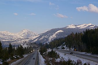
Looking northeast along I-80 in the Sierra Nevada from the Yuba Gap overpass
-
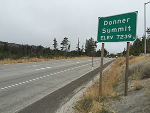
Sign for Donner Summit
-
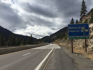
Entering California from Nevada along I-80
-
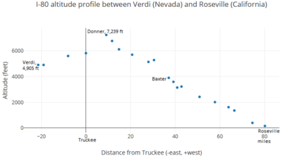
Elevations along a 100-mile (160 km) stretch of the I-80, peaking at Donner saddle


History of I-80
Old Highway Paths

|
|
|
|---|---|
| Location: | San Francisco–Nevada state line |
| Existed: | 1926–1964 |
In California, I-80 was built mostly along the path of US 40. US 40 was removed from California's highway system in 1964. US 40 was one of the first U.S. routes created in 1926. Before the San Francisco–Oakland Bay Bridge opened in 1936, cars would take a ferry from Berkeley to San Francisco. After the bridge was built, US 40 and US 50 used the bridge.
US 40 and US 50 shared the Bay Bridge. They split up in Oakland at a place called the MacArthur Maze. US 40 then followed a path very similar to today's I-80. In Sacramento, US 40 and US 50 joined again. US 40 then split off again and followed what is now I-80 Business. This was the original I-80 route from 1957 to 1981. Later, I-80 was moved to a new path around Sacramento. US 40 then continued through the Sierra Nevada mountains into Nevada, just like I-80 does today.
A part of the old US 40 near Donner Lake is still there. It's an alternate route to I-80. It goes right by Donner Lake, while I-80 goes higher up in the mountains.
Building the Highway
Original Plans in San Francisco

When I-80 was first planned, it was supposed to start in Golden Gate Park. It would have gone east on a freeway that was never built, called the Panhandle Freeway. Then it would have connected to the San Francisco Skyway. However, in 1964, people in the community protested. This led Caltrans to cancel the Panhandle Freeway project. The starting point of I-80 was then changed to the Embarcadero Freeway. Even though some parts of the original plan were canceled, the San Francisco Skyway is still considered part of I-80 today.
What I-80 Changed
Before I-80 was built, the old US 40 road had many accidents. This was because it had many traffic lights and stop signs that appeared suddenly. Caltrans said that building I-80 would make the road much safer. A study in Vallejo showed that after the freeway was built, the accident rate dropped by 73 percent.
The new I-80 also made traveling across the Sierra Nevada mountains much easier. The old US 40 was a narrow, winding road that often closed in winter due to heavy snow at Donner Pass. Drivers had to take a much longer route. With I-80, crossing the mountains became much simpler. The new Donner Summit pass is usually only closed during the worst snowstorms.
Bay Bridge Rebuilt

On October 17, 1989, a big earthquake called the Loma Prieta earthquake hit. It caused a lot of damage and sadly, many people died or were hurt. The San Francisco–Oakland Bay Bridge, which is part of I-80, was badly damaged. A large section of the upper deck on the eastern side fell onto the lower deck. Caltrans quickly fixed the bridge, and it reopened on November 18, 1989.

Because of the earthquake risk, Caltrans started building a new eastern part of the Bay Bridge in 2002. This new part was designed to be much stronger and safer in an earthquake. The new eastern span opened on September 2, 2013. It cost about $6.4 billion to build.
Express Lanes Added
In May 2022, Caltrans started building special lanes called high-occupancy toll (HOT) lanes on I-80. These lanes are between Fairfield and Vacaville. They are about 18 miles (29 km) long. These lanes allow cars with multiple passengers to use them for free, while single-driver cars can pay a toll. The project also changed existing carpool lanes into HOT lanes. These new lanes were completed in 2025. They use a system where you pay tolls without stopping at a booth, using a device called a FasTrak transponder.
In May 2024, more money was approved to add HOT lanes between Davis and West Sacramento. These lanes will help reduce traffic in those areas.
Exit List
| County | Location | Mile | Roads intersected | Notes | ||
|---|---|---|---|---|---|---|
| City and County of San Francisco | 0.00– 0.91 |
0.00– 1.46 |
1A | Western terminus; US 101 north exit 433B, south exit 433 | ||
| 1B | ||||||
| 1 | Seventh Street | Eastbound exit and westbound entrance | ||||
| 1C | Ninth Street – Civic Center | Westbound exit and eastbound entrance | ||||
| 1.91– 2.02 |
3.07– 3.25 |
2A | Fifth Street | Westbound exit and eastbound entrance | ||
| 2 | Fourth Street | Eastbound exit and westbound entrance | ||||
| 2B | Harrison Street / Embarcadero | Westbound exit and eastbound entrance; former Fremont Street exit | ||||
| 2C | Fremont Street / Folsom Street | Westbound exit and eastbound entrance; provides buses only access to Salesforce Transit Center; former Main Street / SR 480 exit | ||||
| San Francisco Bay | 3.75 | 6.04 | San Francisco–Oakland Bay Bridge (west span) | |||
| City and County of San Francisco | 4.18 | 6.73 | 4A | Treasure Island | Eastbound left exit and westbound entrance; connects to Treasure Island Road; scheduled to close in late May 2023 for a few of years during a seismic retrofit of the Bay Bridge western span | |
| Yerba Buena Tunnel | ||||||
| 4B | Yerba Buena Island / Treasure Island | Signed as exit 4 westbound; original eastbound off-ramp was demolished as part of the Bay Bridge eastern span replacement but its replacement ramp was not completed until May 2023; connects to Macalla Road/Hillcrest Road | ||||
| San Francisco Bay | 5.31 | 8.55 | San Francisco–Oakland Bay Bridge (east span; westbound toll only) | |||
| Alameda | Oakland | 7.83 | 12.60 | 8A | Eastbound exit and westbound entrance; western end of MacArthur Maze; I-880 exit 46A; access to Oakland International Airport; former SR 17 south | |
| ♦ | Bay Bridge Toll Plaza parking lot only | Access via the HOV lane; entrance to Bay Bridge via left turn at a stop sign at the west side of the complex | ||||
| 8A | West Grand Avenue, Maritime Street | Westbound signage; eastbound access via exit 8A/I-880; last free exit for westbound traffic | ||||
| 8.13 | 13.08 | 8B | Eastbound signage; I-580 west exit 19A | |||
| Western end of I-580 overlap; westbound left exit and eastbound entrance; eastern end of MacArthur Maze; I-880 exit 46B; I-880 was former SR 17 south; access to Oakland International Airport | ||||||
| Emeryville | 9.10 | 14.65 | 9 | Powell Street – Emeryville | No eastbound exit from I-880 north | |
| Emeryville–Berkeley line | 9.89 | 15.92 | 10 | Shellmound Street accessible eastbound only | ||
| Berkeley | 11.13 | 17.91 | 11 | University Avenue – Berkeley | Serves UC Berkeley | |
| 11.91 | 19.17 | 12 | Gilman Street | |||
| Albany | 12.61 | 20.29 | 13A | Buchanan Street – Albany | Eastbound signage; partially rebuilt as part of 1990s reconstruction of the Hoffman Split interchange | |
| 12.91 | 20.78 | 13B | Eastern end of I-580 overlap; Hoffman Split interchange; eastbound exit and westbound entrance; former SR 17 north | |||
| 13 | Albany | Westbound signage; connects to Cleveland Avenue | ||||
| — | Pierce Street | Former eastbound exit and entrance; demolished during the 1990s reconstruction of the Hoffman Split interchange | ||||
| Contra Costa | Richmond | 13.57 | 21.84 | 14A | Central Avenue – El Cerrito | El Cerrito not signed westbound |
| 14.35 | 23.09 | 14B | Carlson Boulevard | |||
| Richmond–El Cerrito line | 15.02 | 24.17 | 15 | Potrero Avenue | Eastbound exit and westbound entrance | |
| Richmond | Cutting Boulevard (SR 123) | Westbound exit and eastbound entrance | ||||
| ♦ | Cutting Boulevard | HOV access only; westbound left exit and eastbound entrance | ||||
| 15.97 | 25.70 | 16A | Macdonald Avenue | Eastbound exit and westbound entrance | ||
| 16.31 | 26.25 | 16B | San Pablo Avenue, Barrett Avenue | Signed as exit 16 westbound; Barrett Avenue formerly signed as Central Richmond | ||
| 16.76 | 26.97 | 17 | Solano Avenue | Eastbound exit and westbound entrance | ||
| McBryde Avenue | Westbound exit only | |||||
| San Pablo | 17.69 | 28.47 | 18 | San Pablo Dam Road | ||
| Richmond | 18.60 | 29.93 | 19A | El Portal Drive | ||
| 19.33 | 31.11 | 19B | Hilltop Mall, Auto Plaza | Formerly signed as Hilltop Drive | ||
| Richmond–Pinole line | ♦ | Richmond Parkway | HOV access only; eastbound left exit and westbound entrance | |||
| Pinole | 19.95 | 32.11 | 20 | Unconstructed SR 93 | ||
| 20.95 | 33.72 | 21 | Appian Way | |||
| 21.86 | 35.18 | 22 | Pinole Valley Road | |||
| Hercules | 23.41 | 37.67 | 23 | Eastbound signage; no westbound access to SR 4 east; SR 4 exit 1B | ||
| Hercules | Westbound signage | |||||
| 24.04 | 38.69 | 24 | Willow Avenue – Rodeo | |||
| | 26.10 | 42.00 | 26 | |||
| | 26.84 | 43.19 | 27 | Pomona Street – Crockett, Port Costa | Last free exit for eastbound traffic | |
| Carquinez Strait | 27.49 | 44.24 | Carquinez Bridge (eastbound toll only) | |||
| Solano | Vallejo | 28.63– 28.79 |
46.08– 46.33 |
29A | Eastbound exit and westbound entrance | |
| Maritime Academy Drive | Westbound exit and entrance | |||||
| 29B | Sequoia Avenue | Eastbound exit only | ||||
| 29.27 | 47.11 | 29C | Magazine Street | Signed as exit 29B westbound | ||
| 29.71 | 47.81 | 30A | Provides exit to Curtola Parkway; I-780 is former I-680 south; I-780 exit 1A-B | |||
| 29.93 | 48.17 | 30B | Frontage Road (to Benicia Road) | Eastbound exit only; former SR 141 | ||
| 30.37 | 48.88 | 30C | Georgia Street – Central Vallejo | Signed as exit 30B westbound | ||
| 30.72 | 49.44 | 31A | Springs Road, Solano Avenue | |||
| 30.98 | 49.86 | 31B | Tennessee Street – Mare Island | |||
| 31.92 | 51.37 | 32 | Redwood Parkway, Redwood Street | Signed as exits 32A (east) and 32B (west) eastbound | ||
| 33.12 | 53.30 | 33 | Signed as exits 33A (Columbus Parkway) and 33B (SR 37) westbound; SR 37 exit 21A to I-80 west | |||
| 34.12 | 54.91 | Hunter Hill Rest Area (westbound only) | ||||
| Napa–Solano county line |
35.59 | 57.28 | 36 | American Canyon Road | ||
| Solano | Fairfield | 38.88 | 62.57 | 39A | Red Top Road | Signed as exit 39 eastbound |
| — | I-80 Express Lanes | West end of express lanes-under construction; scheduled to open in 2025 | ||||
| 39B | Western end of SR 12 overlap; eastbound access is via exit 40 | |||||
| 40.34– 40.99 |
64.92– 65.97 |
40 | Westbound access is part of exit 41 | |||
| Former SR 21; I-680 north exits 71A-B | ||||||
| 41 | Suisun Valley Road, Pittman Road, Green Valley Road | Green Valley Road not signed eastbound; Pittman Road not signed westbound | ||||
| 43.32 | 69.72 | 43 | Eastern end of SR 12 overlap; westbound access is via exit 43 | |||
| 43.64 | 70.23 | 44A | Signed as exit 43 westbound | |||
| 44.22 | 71.17 | 44B | West Texas Street, Rockville Road | Signed as exit 44 westbound | ||
| 45.42 | 73.10 | 45 | Travis Boulevard | |||
| 46.68 | 75.12 | 47 | Waterman Boulevard, Air Base Parkway – Travis AFB | Signed as exits 47A (Air Base Parkway) and 47B (Waterman Boulevard) westbound | ||
| 48.30 | 77.73 | 48 | North Texas Street, Manuel Campos Parkway | |||
| Vacaville | 50.62 | 81.46 | 51A | Lagoon Valley Road, Cherry Glen Road | ||
| 51.16 | 82.33 | 51B | Peña Adobe Road | |||
| 52 | Cherry Glen Road | Westbound exit only | ||||
| 52.81 | 84.99 | 53 | Alamo Drive, Merchant Street | |||
| 53.51 | 86.12 | 54A | Davis Street | |||
| 53.97 | 86.86 | 54B | Peabody Road, Mason Street – Elmira | |||
| 54.74 | 88.10 | 55 | Monte Vista Avenue, Allison Drive, Nut Tree Parkway | |||
| 55.86 | 89.90 | 56 | I-505 exits 1A-B | |||
| — | I-80 Express Lanes | East end of express lanes-under construction; scheduled to open in 2025 | ||||
| 57.29 | 92.20 | 57 | Leisure Town Road, Vaca Valley Parkway | |||
| 58.80 | 94.63 | 59 | Meridian Road, Weber Road | |||
| 60.12 | 96.75 | 60 | Midway Road, Lewis Road | |||
| Dixon | 64.04 | 103.06 | 63 | Dixon Avenue, West A Street | ||
| 64.38 | 103.61 | 64 | Pitt School Road | |||
| 65.70 | 105.73 | 66A | Western end of SR 113 overlap; signed as exit 66 eastbound | |||
| 66B | Milk Farm Road | Westbound exit only | ||||
| 67.22 | 108.18 | 67 | Pedrick Road (CR E7) | |||
| | 68.74 | 110.63 | 69 | Kidwell Road | ||
| | 70.16 | 112.91 | 70 | Eastern end of SR 113 overlap; SR 113 exits 26A-B | ||
| | 70.50 | 113.46 | 71 | UC Davis | Connects to Old Davis Road | |
| Yolo | Davis | 72.44 | 116.58 | 72 | Richards Boulevard – Downtown Davis | Signed as exits 72A (south) and 72B (north) westbound |
| 73.05 | 117.56 | 73 | Olive Drive | Westbound exit only; former US 40 west / US 99W north | ||
| 74.89 | 120.52 | 75 | Mace Boulevard (CR E6) | |||
| | 78.00 | 125.53 | 78 | Road 32A, East Chiles Road | ||
| Yolo Bypass | 78.02– 79.46 |
125.56– 127.88 |
Yolo Causeway | |||
| West Sacramento | 81.39 | 130.98 | 81 | West Capitol Avenue, Enterprise Boulevard | West Capitol Avenue was former US 40 east / US 99W south | |
| 82.12 | 132.16 | 82 | Eastbound exit and westbound entrance are on the left; former I-80 / US 40 east / US 99W south; US 50 exit 1 | |||
| 83.46 | 134.32 | 83 | Reed Avenue (SR 84) | |||
| Sacramento | Sacramento | 85.29 | 137.26 | 85 | West El Camino Avenue | |
| 86.48 | 139.18 | 86 | I-5 exit 522 | |||
| 87.58 | 140.95 | 88 | Truxel Road | |||
| 88.91 | 143.09 | 89 | Northgate Boulevard | |||
| 90.05 | 144.92 | 90 | Norwood Avenue | |||
| 91.56 | 147.35 | 91 | Raley Boulevard, Marysville Boulevard – Del Paso Heights | |||
| 92.60 | 149.03 | 92 | Winters Street | |||
| 93.33 | 150.20 | 93 | Longview Drive | |||
| North Highlands | 94.29– 94.83 |
151.75– 152.61 |
94 | Light Rail Stations (Roseville Road, Watt/I-80 West, and Watt/I-80) | Westbound left exit and eastbound left entrance; also accessible as part of exit 93 westbound; due to the nature of the left hand ramps, all vehicles are allowed access to the HOV lanes for 0.5 miles (0.80 km) to and from the ramps | |
| 94A | Watt Avenue | Westbound access via exit 95 | ||||
| 94B | Auburn Boulevard (SR 244) | |||||
| 94.94 | 152.79 | 95 | Westbound exit and eastbound entrance; eastbound exit is part of exit 94A; former I-80 west | |||
| 96.41 | 155.16 | 96 | Madison Avenue | |||
| Foothill Farms–Carmichael line | 98.38 | 158.33 | 98 | Greenback Lane, Elkhorn Boulevard (CR E14) | ||
| Citrus Heights | 100.62 | 161.93 | 100 | Antelope Road | ||
| Sacramento–Placer county line |
Citrus Heights–Roseville line | 102.20 | 164.47 | 102 | Riverside Avenue, Auburn Boulevard – Roseville, Citrus Heights | Former US 40 / US 99E / SR 65 |
| Placer | Roseville | 103.91 | 167.23 | 103 | Douglas Boulevard, Sunrise Avenue (CR E2) | Signed as exits 103A (east) and 103B (west) eastbound |
| 105.00 | 168.98 | 105A | Atlantic Street, Taylor Road, Eureka Road | Taylor Road not signed eastbound; signed as exits 105A (Eureka Road) and 105B (Atlantic Street, Taylor Road) westbound | ||
| 105.59 | 169.93 | 105B | Taylor Road, Pacific Street | Westbound exit is via exit 105A | ||
| Roseville–Rocklin line | 106.09 | 170.74 | 106 | SR 65 exits 306A-B | ||
| Rocklin | 107.99 | 173.79 | 108 | Rocklin Road | ||
| 109.35 | 175.98 | 109 | Sierra College Boulevard (CR E3) | |||
| Loomis | 110.65 | 178.07 | 110 | Horseshoe Bar Road | ||
| Penryn | 112.28 | 180.70 | 112 | Penryn Road – Penryn | ||
| Newcastle | 115.74 | 186.27 | 115 | Newcastle Road – Newcastle | ||
| 116.23 | 187.05 | 116 | Western end of SR 193 overlap | |||
| Auburn | 118.84 | 191.25 | 118 | Ophir Road | Westbound exit and eastbound entrance | |
| 119.22 | 191.87 | 119A | Maple Street, Nevada Street | |||
| 119.47 | 192.27 | 119B | Western end of SR 49 overlap | |||
| 119.76 | 192.74 | 119C | Eastern end of SR 49 / SR 193 overlap | |||
| Auburn–North Auburn line | 120.87 | 194.52 | 120 | Lincoln Way, Russell Road | No eastbound entrance | |
| North Auburn | 121.40 | 195.37 | 121 | Auburn Ravine Road – Foresthill | ||
| 122.06 | 196.44 | 122 | Bowman | Connects to Bowman Road | ||
| | 123.06 | 198.05 | 123 | Bell Road | ||
| | 124.14 | 199.78 | 124 | Dry Creek Road | ||
| | 125.36 | 201.75 | 125 | Clipper Gap, Meadow Vista | Connects to Placer Hills Road | |
| | 128.14 | 206.22 | 128 | Applegate | Connects to Crother Road | |
| | 129.32 | 208.12 | 129 | Heather Glen | Connects to Applegate Road and Geisendorfer Road | |
| | 130.52 | 210.05 | 130 | West Paoli Lane | ||
| | 131.25 | 211.23 | 131 | Weimar Cross Road | ||
| Colfax | 133.72 | 215.20 | 133 | Canyon Way, Placer Hills Road | ||
| 135.06 | 217.36 | 135 | ||||
| | 140.28 | 225.76 | 139 | Rollins Lake Road, Magra Road | Westbound exit and entrance | |
| | 140 | Secret Town Road, Magra Road | ||||
| | 143.30 | 230.62 | 143 | Magra Road – Gold Run | ||
| | 143.68 | 231.23 | Gold Run Rest Area | |||
| | 144.13 | 231.95 | 144 | Gold Run | Westbound exit and eastbound entrance; connects to Gold Run Road and Hi Sierra Drive | |
| | 145.10 | 233.52 | 145 | Dutch Flat | Connects to Canyon Creek Road and Ridge Road | |
| | 146.68 | 236.06 | 146 | Alta | Connects to Alta Bonnynook Road and Morton Road | |
| Alta | 148.24 | 238.57 | 148A | Crystal Springs | Connects to Crystal Springs Road | |
| | 148.87 | 239.58 | 148B | Baxter | Connects to Baxter Road | |
| | 150.93 | 242.90 | 150 | Drum Forebay Road | ||
| | 155.29 | 249.92 | 155 | Blue Canyon | Connects to Blue Canyon Road | |
| | 156.74 | 252.25 | 156 | Nyack Road | ||
| | 157.99 | 254.26 | 158A | Emigrant Gap | Signed as exit 158 westbound; connects to Emigrant Gap Road | |
| | 158.79 | 255.55 | 158B | Laing Road | Eastbound exit only | |
| Nevada | | 160.77 | 258.73 | 160 | Yuba Gap | Connects to Lake Valley Road |
| | 161.47 | 259.86 | 161 | |||
| | 163.96 | 263.87 | 164 | Eagle Lakes Road | ||
| Placer | | 165.45 | 266.27 | 165 | Cisco Grove | Connects to Cisco Road |
| | 166.73 | 268.33 | 166 | Big Bend | Eastbound exit only; connects to Hampshire Rocks Road | |
| | 168.13 | 270.58 | 168 | Rainbow Road – Big Bend | ||
| Kingvale | 171.16 | 275.46 | 171 | Kingvale | Connects to Donner Pass Road | |
| Nevada | Soda Springs | 173.84 | 279.77 | 174 | Soda Springs, Norden | Connects to Donner Pass Road; former US 40 |
| | 176.23 | 283.61 | 176 | Boreal Ridge Road – Castle Peak | ||
| | 176.66 | 284.31 | Donner Summit Rest Area | |||
| | 176.90– 176.99 |
284.69– 284.84 |
Donner Summit, elevation 7,227 feet (2,203 m) eastbound, 7,239 feet (2,206 m) westbound |
|||
| Truckee | 180.16 | 289.94 | 180 | Donner Lake | Connects to Donner Lake Road | |
| 184.91 | 297.58 | 184 | Donner Pass Road | Former US 40 | ||
| 185.86 | 299.11 | 185 | Western end of SR 89 overlap | |||
| 186.67 | 300.42 | 186 | Central Truckee | No eastbound entrance; connects to Donner Pass Road; former US 40 | ||
| 187.99 | 302.54 | 188A | Truckee | Eastbound exit and westbound entrance; connects to Truckee Way | ||
| 188.30 | 303.04 | 188B | Eastern end of SR 89 overlap; signed as exit 188 westbound | |||
| 189.98 | 305.74 | 190 | Overland Trail | Formerly Prosser Village Road | ||
| 190.96 | 307.32 | Agricultural Inspection Station (westbound only) | ||||
| 194.11 | 312.39 | 194 | Hirschdale Road | |||
| Floriston | 198.99 | 320.24 | 199 | Floriston | Connects to Floriston Way | |
| | 201.19 | 323.78 | 201 | Farad | Connects to Mystic Road | |
| Sierra | | 205.07 | 330.03 | Continuation into Nevada | ||
| 1.000 mi = 1.609 km; 1.000 km = 0.621 mi | ||||||
Other Highways Connected to I-80
Many other Interstate highways are connected to I-80 in California, especially around the San Francisco Bay Area. These are called "auxiliary" Interstates.
- I-280 runs from San Jose north to San Francisco.
- I-380 connects I-280 in San Bruno to US 101 near San Francisco International Airport.
- I-580 goes from San Rafael east to I-5 in the Central Valley.
- I-680 runs from San Jose north to I-80 in Fairfield, curving around the eastern side of the Bay Area.
- I-780 connects I-80 in Vallejo with I-680 in Benicia.
- I-880 connects San Jose with I-80 and I-580 in Oakland. It runs along the eastern shore of San Francisco Bay.
- I-980 connects I-880 with I-580 in Oakland.
There's also a special highway called I-238. It connects I-580 in Castro Valley with I-880 in San Leandro. Even though its number doesn't follow the usual rules for Interstates, it's still connected to the I-80 family of roads.
A special loop of I-80, called I-80 Business, goes through Sacramento. This used to be the main I-80 route.
Some Interstate routes that were once connected to I-80 no longer exist:
- I-180 was a name for part of the Richmond–San Rafael Bridge for a few years. It later became part of I-580.
- I-480 was planned for San Francisco. Only parts of it were built, like the Embarcadero Freeway. This freeway was taken down after the 1989 earthquake.
- I-880 was the original name for the northern bypass freeway in Sacramento. I-80 was later moved to this route.
See also
 In Spanish: Interestatal 80 (California) para niños
