
Citrus Heights, California facts for kids
Quick facts for kids
Citrus Heights, California
|
|||||
|---|---|---|---|---|---|
|
|||||

Location of Citrus Heights in Sacramento County and California
|
|||||

Citrus Heights, California
Location in the United States
|
|||||
| Country | United States | ||||
| State | California | ||||
| County | Sacramento | ||||
| Incorporated | January 1, 1997 | ||||
| Area | |||||
| • Total | 14.22 sq mi (36.82 km2) | ||||
| • Land | 14.22 sq mi (36.82 km2) | ||||
| • Water | 0.00 sq mi (0.00 km2) 0% | ||||
| Elevation | 167 ft (51 m) | ||||
| Population
(2020)
|
|||||
| • Total | 87,583 | ||||
| • Rank | 93rd in California | ||||
| • Density | 6,160.88/sq mi (2,378.65/km2) | ||||
| Time zone | UTC-8 (PST) | ||||
| • Summer (DST) | UTC-7 (PDT) | ||||
| ZIP codes |
95610, 95611 (PO Box only), 95621
|
||||
| Area code | 916, 279 | ||||
| FIPS code | 06-13588 | ||||
| GNIS feature ID | 1655900 | ||||


Citrus Heights is a city in Sacramento County, California, United States. It's located in the central part of California. In 2020, about 87,583 people lived here. This was an increase from 83,301 people in 2010.
Contents
History of Citrus Heights
Citrus Heights became an official city on January 1, 1997. Voters in the area agreed to make it a city on November 5, 1996. About 62.5% of the people voted yes. This made Citrus Heights the fifth city in Sacramento County.
The area was first called Sylvan. But in 1910, a real estate agent bought the land. He divided it into 10-acre lots. Then, he gave the area its new name: Citrus Heights.
Geography and Climate
Citrus Heights covers about 14.22 square miles (36.82 square kilometers). All of this area is land. There are no large bodies of water within the city limits.
What is the Climate Like?
Citrus Heights has a special climate. Winters are usually mild, meaning not too cold. Summers are dry and hot. The air is often not very humid.
The average temperature throughout the year is about 68 degrees Fahrenheit. Daily temperatures can range from 45°F in winter (December and January) to 76°F in summer (July). High temperatures in summer can reach 93°F. Low temperatures in winter can drop to 38°F.
On average, Citrus Heights has 73 days a year when the temperature goes above 90°F. The hottest day ever recorded was 114°F on July 17, 1925. It gets cold enough for the temperature to drop below 32°F about 18 days a year. The coldest day on record was 17°F on December 11, 1932.
The city gets about 24.61 inches of rain each year. Most of the rain falls between November and March. There is almost no rain during the summer months. Citrus Heights usually has 268 sunny days each year. Fog can happen on about 96 days, mostly in the mornings during December and January.
Population Facts
| Historical population | |||
|---|---|---|---|
| Census | Pop. | %± | |
| 1970 | 21,760 | — | |
| 1980 | 85,911 | 294.8% | |
| 1990 | 107,439 | 25.1% | |
| 2000 | 85,071 | −20.8% | |
| 2010 | 83,301 | −2.1% | |
| 2020 | 87,583 | 5.1% | |
| 2023 (est.) | 86,239 | 3.5% | |
| U.S. Decennial Census | |||
Citrus Heights is part of the larger Sacramento metropolitan area. This means it's connected to Sacramento and nearby cities like Arden-Arcade and Roseville.
Population in 2020
In 2020, the population of Citrus Heights was 87,583 people. Most residents were White (about 64.5%). Other groups included Hispanic or Latino (about 19.6%), Mixed race (about 6.6%), Asian (about 4%), and Black or African American (about 3.6%).
About 23.1% of the people were under 18 years old. About 13.3% were 65 years or older. The average age in Citrus Heights was 36.2 years.
Economy and Shopping
Citrus Heights has a busy economy. It is home to the Sunrise Mall. There are also many other shopping centers and large stores. This makes it a good place for shopping and business.
Education in Citrus Heights
Most schools in Citrus Heights are part of the San Juan Unified School District. This is a large school district in California. It covers about 75 square miles in northeast Sacramento County.
Within Citrus Heights, there are:
- Six elementary schools
- One middle school
- Two high schools
These schools teach over 10,000 students from the city. The San Juan Unified School District also offers other learning programs. These include special education centers, adult schools, and preschool programs. They also have before- and after-school care.
Many colleges and universities are near Citrus Heights. These include:
- University of California, Davis
- California State University, Sacramento
- American River College
- Sierra College
City Services
Transportation
Citrus Heights is easy to get to by car. It's located close to major highways. Interstate 80 runs along the west side of the city. Other major roads like Interstate 5, U.S. Highway 50, and California State Route 99 are also nearby.
The Sacramento International Airport is about 20 miles (32 km) west of the city. If you want to travel by train, Amtrak trains are available in Roseville, which is about 5 miles (8 km) north. Public bus transportation is provided by the Sacramento Regional Transit District.
Police Department

In June 2006, Citrus Heights started its own police department. Many experienced police officers from other parts of California joined the new department. On June 26, 2006, the Citrus Heights Police Department took over from the Sacramento County Sheriff's Department.
The police department offers many services. It has special teams like SWAT and Traffic units. They also have officers who work with schools. The department has its own modern communications center. This center answers 9-1-1 calls and sends police officers to help people in the city.
Notable People
Some well-known people have connections to Citrus Heights:
- Bill Conroy - a professional baseball catcher
- Kelley Jones - an artist
- Mandisa - a singer
- Jackie Lynn Taylor - an actress from the old TV show Our Gang
Images for kids
-
The official seal of Citrus Heights.
-

The flag of Citrus Heights.
-

The logo of Citrus Heights.
-
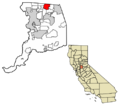
A map showing Citrus Heights in Sacramento County.
See also
 In Spanish: Citrus Heights para niños
