
Sacramento County, California facts for kids
Quick facts for kids
Sacramento County
|
|||
|---|---|---|---|
| County of Sacramento | |||
    Images, from top down, left to right: California State Capitol, Folsom Powerhouse State Historic Park, Stone Lakes National Wildlife Refuge, Sutter's Fort
|
|||
|
|||

Location in the state of California
|
|||
| Country | United States | ||
| State | California | ||
| Region | Sacramento Valley, San Joaquin Valley, Sacramento–San Joaquin River Delta | ||
| Metro area | Greater Sacramento | ||
| Incorporated | February 18, 1850 | ||
| Named for | The capital city of Sacramento, which is named for the Sacrament of the Holy Eucharist | ||
| County seat (and largest city) | Sacramento | ||
| Government | |||
| • Type | Council–CEO | ||
| • Body | Board of Supervisors | ||
| Area | |||
| • Total | 994 sq mi (2,570 km2) | ||
| • Land | 965 sq mi (2,500 km2) | ||
| • Water | 29 sq mi (80 km2) | ||
| Highest elevation | 831 ft (253 m) | ||
| Population | |||
| • Total | 1,585,055 | ||
| • Estimate
(2023)
|
1,584,288 |
||
| • Density | 1,594.6/sq mi (615.69/km2) | ||
| Gross Domestic Product | |||
| • Total | US$98.990 billion (2022) | ||
| Time zone | UTC−8 (Pacific Standard Time) | ||
| • Summer (DST) | UTC−7 (Pacific Daylight Time) | ||
| Area code(s) | 209, 916 | ||
| Congressional districts | 3rd, 6th, 7th | ||


Sacramento County is a county in the state of California. In 2020, about 1,585,055 people lived here. Its main city, Sacramento, is also the state capital of California since 1854.
Sacramento County is the main part of the Greater Sacramento region. It covers about 994 square miles (2,574 km²) in the northern Central Valley. The county stretches from the low delta lands near the Sacramento River to the foothills of the Sierra Nevada Mountains. It even touches San Francisco Bay in its southern part. Recently, California has had many droughts, which makes it harder for the county to get enough water.
| Top - 0-9 A B C D E F G H I J K L M N O P Q R S T U V W X Y Z |
History of Sacramento County
Sacramento County was one of California's first counties. It was created in 1850 when California became a state. The county gets its name from the Sacramento River, which is on its western side. A Spanish officer named Gabriel Moraga named the river "Santisimo Sacramento," which means "Most Holy Sacrament." This refers to a special religious event in the Catholic Church.
A famous explorer, Alexander Hamilton Willard, who was part of the Lewis and Clark Expedition, is buried in the old Franklin Cemetery in the county.
Geography and Nature

Sacramento County covers about 994 square miles (2,574 km²). Most of this area is land (965 sq mi or 2,499 km²), and a smaller part is water (29 sq mi or 75 km²). Much of the county is very close to sea level, and some parts are even below it. The highest point is Carpenter Hill, which is 831 feet (253 meters) tall, located in the southeast near Folsom.
Important rivers in the county include the American River, Sacramento River, and Cosumnes River.
Neighboring Counties
Sacramento County shares its borders with these other counties:
- Sutter County - to the northwest
- Placer County - to the north
- El Dorado County - to the northeast
- Amador County - to the east
- San Joaquin County - to the south
- Contra Costa County - to the southwest
- Solano County - to the west
- Yolo County - to the west
Protected Natural Areas
The county is home to some special protected areas:
- Stone Lakes National Wildlife Refuge
- California National Historic Trail
- Pony Express National Historic Trail
People and Population
| Historical population | |||
|---|---|---|---|
| Census | Pop. | %± | |
| 1850 | 9,087 | — | |
| 1860 | 24,142 | 165.7% | |
| 1870 | 26,830 | 11.1% | |
| 1880 | 34,390 | 28.2% | |
| 1890 | 40,339 | 17.3% | |
| 1900 | 45,915 | 13.8% | |
| 1910 | 67,806 | 47.7% | |
| 1920 | 91,029 | 34.2% | |
| 1930 | 141,999 | 56.0% | |
| 1940 | 170,333 | 20.0% | |
| 1950 | 277,140 | 62.7% | |
| 1960 | 502,778 | 81.4% | |
| 1970 | 631,498 | 25.6% | |
| 1980 | 783,381 | 24.1% | |
| 1990 | 1,041,219 | 32.9% | |
| 2000 | 1,223,499 | 17.5% | |
| 2010 | 1,418,788 | 16.0% | |
| 2020 | 1,585,055 | 11.7% | |
| 2023 (est.) | 1,584,288 | 11.7% | |
| U.S. Decennial Census 1790–1960 1900–1990 1990–2000 2010 2020 |
|||
Population in 2020
In 2020, Sacramento County had 1,585,055 people. The population is very diverse, meaning people from many different backgrounds live here.
| Race / Ethnicity (NH = Non-Hispanic) | Pop 2000 | Pop 2010 | Pop 2020 | % 2000 | % 2010 | % 2020 |
|---|---|---|---|---|---|---|
| White alone (NH) | 706,655 | 687,166 | 650,271 | 57.76% | 48.43% | 41.03% |
| Black or African American alone (NH) | 118,073 | 139,949 | 145,724 | 9.65% | 9.86% | 9.19% |
| Native American or Alaska Native alone (NH) | 9,070 | 7,875 | 7,432 | 0.74% | 0.56% | 0.47% |
| Asian alone (NH) | 132,601 | 198,944 | 276,295 | 10.84% | 14.02% | 17.43% |
| Pacific Islander alone (NH) | 6,788 | 13,099 | 18,011 | 0.55% | 0.92% | 1.14% |
| Other Race alone (NH) | 3,406 | 3,418 | 10,104 | 0.28% | 0.24% | 0.64% |
| Mixed Race or Multi-Racial (NH) | 51,016 | 62,141 | 102,784 | 4.17% | 4.38% | 6.48% |
| Hispanic or Latino (any race) | 195,890 | 306,196 | 374,434 | 16.01% | 21.58% | 23.62% |
| Total | 1,223,499 | 1,418,788 | 1,585,055 | 100.00% | 100.00% | 100.00% |

Population in 2010
In 2010, the county had 1,418,788 people. About 57.5% were White, 15.4% African American, and 14.3% Asian. About 21.6% of the people were Hispanic or Latino.
Education in Sacramento County
Sacramento County has many schools and colleges for students of all ages.
Colleges and Universities
There are several public and private colleges and universities:
- Public Universities
- California State University Sacramento
- UC Davis Extension (includes medical and nursing schools)
- Community Colleges
- Los Rios Community College District (with campuses like American River College, Cosumnes River College, Folsom Lake College, and Sacramento City College)
- San Joaquin Delta Community College District
- Sierra Joint Community College District
- Private Colleges
- University of the Pacific in Sacramento
- National University Sacramento Regional Campus
- University of San Francisco Regional Campus
- Many other specialized private schools
K-12 Schools
The county has many school districts for students from kindergarten through 12th grade:
- Center Joint Unified School District
- Elk Grove Unified School District
- Folsom-Cordova Unified School District
- Natomas Unified School District
- River Delta Unified School District
- Sacramento City Unified School District
- San Juan Unified School District
- Twin Rivers Unified School District
There are also districts just for high school or elementary school.
Getting Around: Transportation

Sacramento County has many ways to travel, from public buses and trains to major highways and airports.
Public Transportation
- Sacramento Regional Transit District (SacRT): This system provides bus and light rail services. The light rail has Blue, Green, and Gold lines.
- Yolobus: Connects Sacramento County with nearby Yolo County, including Davis.
- Both SacRT and Yolobus offer bus services to Sacramento International Airport.
- Amtrak: Passenger trains run from the Sacramento Valley station. You can take trains like the Coast Starlight or California Zephyr to other parts of California and the U.S.
Major Roads and Highways
Many important highways pass through Sacramento County, making it easy to travel by car:
Airports
- Sacramento International Airport: This is a large airport with many passenger flights. It is owned by Sacramento County.
- The county also owns two smaller airports for general aviation: Sacramento Mather Airport and Sacramento Executive Airport.
- Sacramento McClellan Airport: This used to be a military base and is now a privately owned airport.
Local Roads
The Sacramento County Department of Transportation (SACDOT) takes care of about 2,200 miles (3,540 km) of roads in the county's unincorporated areas. These roads range from big six-lane streets to smaller country roads.
Cities and Towns


Sacramento County has several cities and many smaller communities.
Cities
- Citrus Heights
- Elk Grove
- Folsom
- Galt
- Isleton
- Rancho Cordova
- Sacramento (This is the main city and county seat)
Census-Designated Places (CDPs)
These are areas that are like towns but are not officially incorporated as cities.
Unincorporated Community
Population Ranking of Communities (2020 Census)
This table shows the largest cities and towns in Sacramento County based on the 2020 census. † county seat
| Rank | City/town/etc. | Municipal type | Population (2020 Census) |
|---|---|---|---|
| 1 | † Sacramento (State Capital) | City | 524,943 |
| 2 | Elk Grove | City | 176,124 |
| 3 | Arden-Arcade | CDP | 94,659 |
| 4 | Citrus Heights | City | 87,583 |
| 5 | Folsom | City | 80,454 |
| 6 | Carmichael | CDP | 79,793 |
| 7 | Rancho Cordova | City | 79,332 |
| 8 | Florin | CDP | 52,388 |
| 9 | North Highlands | CDP | 49,327 |
| 10 | Antelope | CDP | 48,733 |
| 11 | Vineyard | CDP | 43,935 |
| 12 | Foothill Farms | CDP | 35,834 |
| 13 | Orangevale | CDP | 35,569 |
| 14 | Fair Oaks | CDP | 32,514 |
| 15 | Galt | City | 25,383 |
| 16 | Rosemont | CDP | 23,510 |
| 17 | Parkway | CDP | 15,962 |
| 18 | Rio Linda | CDP | 15,944 |
| 19 | Lemon Hill | CDP | 14,496 |
| 20 | La Riviera | CDP | 11,252 |
| 21 | Gold River | CDP | 7,844 |
| 22 | Fruitridge Pocket | CDP | 6,102 |
| 23 | Wilton | CDP | 5,958 |
| 24 | Rancho Murieta | CDP | 5,903 |
| 25 | Elverta | CDP | 5,435 |
| 26 | Mather | CDP | 4,698 |
| 27 | Walnut Grove | CDP | 1,452 |
| 28 | Clay | CDP | 1,252 |
| 29 | Herald | CDP | 1,160 |
| 30 | McClellan Park | CDP | 926 |
| 31 | Isleton | City | 794 |
| 32 | Courtland | CDP | 326 |
| 33 | Hood | CDP | 244 |
| 34 | Franklin | CDP | 167 |
| 35 | Freeport | CDP | 58 |
Images for kids
-
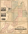
A map of Sacramento County from 1885, showing its different areas.

See also
 In Spanish: Condado de Sacramento para niños
