La Riviera, California facts for kids
Quick facts for kids
La Riviera
|
|
|---|---|

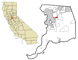
Location in Sacramento County and the state of California
|
|
| Country | |
| State | |
| County | Sacramento |
| Area | |
| • Total | 2.092 sq mi (5.42 km2) |
| • Land | 1.850 sq mi (4.79 km2) |
| • Water | 0.242 sq mi (0.63 km2) 11.56% |
| Elevation | 52 ft (16 m) |
| Population
(2020)
|
|
| • Total | 11,252 |
| • Density | 5,378.6/sq mi (2,076.7/km2) |
| Time zone | UTC-8 (PST) |
| • Summer (DST) | UTC-7 (PDT) |
| ZIP code |
95826 & 95827
|
| Area code(s) | 916, 279 |
| FIPS code | 06-40410 |
| GNIS feature ID | 1867035 |
La Riviera is a special kind of community called a census-designated place (CDP) in Sacramento County, California, United States. It's part of the larger Sacramento metropolitan area. In 2010, about 10,802 people lived there. La Riviera is mostly a neighborhood where people live. It is located between the American River to the north and Highway 50 to the south.
Contents
Geography of La Riviera
La Riviera is located at coordinates 38.566773 degrees North and -121.356772 degrees West.
The total area of La Riviera is about 2.1 square miles (5.4 square kilometers). Most of this area, about 1.9 square miles (4.9 square kilometers), is land. The rest, about 0.2 square miles (0.5 square kilometers), is water. This means about 11.56% of La Riviera is covered by water.
People of La Riviera (Demographics)
| Historical population | |||
|---|---|---|---|
| Census | Pop. | %± | |
| U.S. Decennial Census | |||
Population in 2010
The 2010 United States Census counted 10,802 people living in La Riviera. This means there were about 5,165 people per square mile.
Most of the people in La Riviera were White (67.7%). Other groups included African American (10.0%), Asian (7.1%), Native American (0.7%), and Pacific Islander (0.8%). About 6.2% of people were from other races, and 7.4% identified as two or more races. People of Hispanic or Latino background made up 16.3% of the population.
Almost everyone (99.2%) lived in homes with families or housemates. Only a small number lived in group homes or institutions.
There were 4,475 homes in La Riviera. About 26.1% of these homes had children under 18 living there. Many homes (37.2%) were married couples. Other homes included single parents or individuals living alone. The average home had 2.39 people.
The population included people of all ages. About 19.6% were under 18 years old. About 13.7% were between 18 and 24. The largest group, 29.0%, was between 25 and 44 years old. About 12.7% of the population was 65 years or older. The average age in La Riviera was 35.1 years.
Most homes (55.0%) were owned by the people living in them. The rest (45.0%) were rented.
Getting Around (Transportation)
La Riviera has good public transportation. It is located on the "Gold Line" of Regional Transit's light rail system. This is a train system that helps people travel around the area.
Several light rail stations are located right in La Riviera:
- Watt/Manlove
- Starfire
- Tiber
- Butterfield
Shopping and Businesses (Commercial and Industry)
The main shopping area for La Riviera is the Glenbrook Shopping Center. It is located on La Riviera Drive near the Watt Avenue exit.
There are also other shops and businesses along Folsom Boulevard. This is a major street that runs through the area. Near the Butterfield light rail station, you can find a large office building for the California Franchise Tax Board.
Learning and Schools (Education)
Students in La Riviera attend schools from two different school districts. These are the Sacramento City Unified School District and the Folsom-Cordova School District.
High Schools
The main high school for La Riviera is Rosemont High School. It also serves the nearby Rosemont area. Rosemont High School opened in 2003 and is part of the Sacramento City schools.
See also
 In Spanish: La Riviera para niños
 | William L. Dawson |
 | W. E. B. Du Bois |
 | Harry Belafonte |

