Cosumnes River facts for kids
Quick facts for kids Cosumnes River |
|
|---|---|

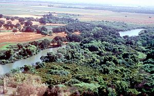
View of the lower Cosumnes River
|
|

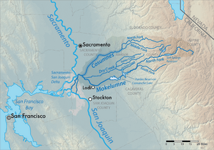
Map of the Mokelumne River watershed, with the Cosumnes River highlighted
|
|
| Country | United States |
| State | California |
| Cities | Plymouth, Rancho Murieta, Sloughhouse, Wilton, Elk Grove, Galt. |
| Physical characteristics | |
| Main source | Sierra Nevada Confluence of North and Middle Forks, El Dorado County 787 ft (240 m) 38°33′13″N 120°50′50″W / 38.55361°N 120.84722°W |
| River mouth | Mokelumne River Near Galt, Sacramento County 13 ft (4.0 m) 38°15′20″N 121°26′21″W / 38.25556°N 121.43917°W |
| Length | 52.5 mi (84.5 km) |
| Basin features | |
| Basin size | 724 sq mi (1,880 km2) |
| Tributaries |
|
The Cosumnes River is a river in northern California, USA. It starts high up in the Sierra Nevada mountains and flows about 52.5 miles (84.5 km) into California's Central Valley. It eventually joins the Mokelumne River in the Sacramento-San Joaquin Delta.
What makes the Cosumnes special is that it's one of the last big rivers on the west side of the Sierra Nevada mountains without huge dams. This means it flows freely, which is great for nature! The Cosumnes River Preserve, a special nature area, is located along the river. Many towns and cities are found along the Cosumnes River, including Plymouth, Rancho Murieta, Sloughhouse, Wilton, Elk Grove, and Galt.
Because of some past issues like pollution, it's advised to be careful if you eat fish caught from the lower part of the Cosumnes River.
Contents
What's in a Name? The Cosumnes River Story
The name "Cosumnes River" comes from the Miwok language. It's similar to how the Mokelumne and Tuolumne rivers got their names. The "-umne" part means "people of." The first part, "kosum," means "salmon." So, the name basically means "salmon people's river."
Sadly, you don't often see Chinook salmon swimming upstream past Rancho Murieta anymore. This is because water is taken out of the river in that area.
Did you know there's a college named after the river? Cosumnes River College is a community college in Sacramento, California. It's only a few miles from the river. Their mascot is a Hawk because many hawks live around the river!
River Journey: Exploring the Cosumnes Geography
The Cosumnes River begins in the western part of the central Sierra Nevada mountains. It starts as three main branches: the North, Middle, and South forks. These forks cut through canyons in El Dorado and Amador County, which are known as "Gold Country." They all join together just east of Highway 49.
North Fork's Path
The North Fork is about 49.3 miles (79.3 km) long. It starts high up at Singleton Springs in El Dorado County, about 7,400 feet (2,256 m) above sea level. It flows west, passing a small community called Meiss. It also gets water from Van Horn Creek and Butte Creek. Near Somerset, it's joined by Camp Creek, its biggest tributary. After that, it flows through the Cosumnes River Gorge, a popular spot for rock climbing. Then, the river turns sharply south and passes Nashville before meeting the Middle Fork.
Middle and South Forks
The Middle Fork is about 44.2 miles (71.1 km) long. It also starts in El Dorado County, not far from the North Fork's source. It flows west, just like the North Fork. The upper part of this river flows through a steep canyon, past Croft, and gets water from Dogtown Creek. Further down, it flows through a gentler valley past Outingdale. Then, it enters another short canyon where the smaller South Fork joins it. The South Fork is about 20 miles (32 km) long and flows along the border of El Dorado and Amador counties. Soon after the South Fork joins, the Middle Fork meets the North Fork, and that's where the main Cosumnes River officially begins!
The Main River's Flow
The main Cosumnes River continues flowing west. It gets more water from Big Indian Creek and passes under SR 49. It winds through the beautiful Sierra foothills, going through short canyons and small ranching valleys. It receives Big Canyon Creek and Little Indian Creek. Then, it flows through its last canyon before reaching the old mining town of Michigan Bar. The river forms the border between El Dorado and Amador counties for a long stretch. After Michigan Bar, it flows into southern Sacramento County.
The Cosumnes River then flows west through Rancho Murieta, a fancy suburb of Sacramento. There are two small dams here that take water from the river. Below Rancho Murieta, the Cosumnes flows through farmland, turning southwest near Sloughhouse. A few miles downstream, the Folsom South Canal goes under the Cosumnes River using a special pipe called an inverted siphon.
The Cosumnes keeps flowing southwest, passing Sheldon and Wilton. It gets water from Deer Creek and then goes under Highway 99 near Elk Grove. After Highway 99, it enters the huge Cosumnes River Preserve, which is almost 50,000 acres (20,234 ha)! This preserve has some of the biggest remaining wetlands and riverbank areas in the Central Valley. Finally, the river enters the Sacramento–San Joaquin River Delta near Mokelumne City. It turns west one last time to join the Mokelumne River on the border of Sacramento and San Joaquin County.
River Changes: Dams and Wildlife
The Cosumnes is special because it's one of the last rivers flowing from the Sierra Nevada mountains without a major dam. This makes it a great example of a healthy river system. However, its salmon and steelhead fish have faced problems. These include harmful fish species that don't belong there, pollution from old mining activities, and the two small dams near Rancho Murieta that take water. There are plans to help salmon return to the river to lay their eggs.
Some water is taken from two smaller streams that feed the North Fork – Camp Creek and Sly Park Creek. This water is used for farming in the Camino area. The Sly Park Dam is the biggest water storage place in the Cosumnes River area. It creates Jenkinson Lake, which holds about 41,000 acre-feet (50,572,000 m³) of water. This dam is part of a bigger water project called the Central Valley Project. But it doesn't really affect the main river's flow much, and it doesn't block the paths where salmon used to swim.
There have been ideas to build bigger dams on the main Cosumnes River to control floods. However, these plans haven't moved forward. This is because the river is so unique for flowing freely and is very important for wildlife. Officials in Sacramento County still want to build a special kind of dam called a dry dam above Rancho Murieta at Michigan Bar. This dam would only hold back water during floods. People are still debating whether to build it.
 | George Robert Carruthers |
 | Patricia Bath |
 | Jan Ernst Matzeliger |
 | Alexander Miles |


