
Rancho Cordova, California facts for kids
Quick facts for kids
Rancho Cordova, California
|
||
|---|---|---|

Hagan Community Park
|
||
|
||
| Motto(s):
"City Life Reinvented"
|
||

City in Sacramento County
|
||

Rancho Cordova, California
Location in California

Rancho Cordova, California
Location in the United States
|
||
| Country | ||
| State | ||
| County | ||
| Incorporated | July 1, 2003 | |
| Government | ||
| • Type | Council–manager | |
| Area | ||
| • Total | 34.88 sq mi (90.33 km2) | |
| • Land | 34.57 sq mi (89.53 km2) | |
| • Water | 0.31 sq mi (0.80 km2) 1.08% | |
| Elevation | 89 ft (27 m) | |
| Population
(2020)
|
||
| • Total | 79,332 | |
| • Density | 2,274.4/sq mi (878.25/km2) | |
| Time zone | UTC-8 (Pacific) | |
| • Summer (DST) | UTC-7 (PDT) | |
| ZIP codes |
95670, 95741, 95742
|
|
| Area code(s) | 916, 279 | |
| FIPS code | 06-59444 | |
| GNIS feature ID | 1659466 | |

Rancho Cordova is a city in Sacramento County, California, United States. It became a city in 2003. Rancho Cordova is part of the bigger Sacramento Metropolitan Area. About 79,332 people lived there in 2020. It even won the All-America City Award in 2010 and 2019, which means it's a great place to live!
Contents
History of Rancho Cordova
Early Days and Gold Rush Era
Rancho Cordova was first known by different names during the California Gold Rush around 1855. It was called Mayhew's Crossing and Hangtown Crossing. Later, around 1900, these places were renamed Mayhew Station and Mills Station. The city got its current name from the Cordova Vineyard. This vineyard was located in the middle of a large land grant called Rancho Rio de los Americanos. Before becoming Rancho Cordova, the area was also known as Cordova Vineyards and Cordova Village. The name Rancho Cordova became official when a post office opened there in 1955.
During the Gold Rush in the mid-1800s, people searched for gold by placer mining around Rancho Cordova. You can still find some signs of this history today. The land is mostly flat and sits about 118 feet (36 meters) above sea level. Companies like Lone Star Gravel Company used to dig for gravel here. They found gravel about 30 to 40 feet (9 to 12 meters) deep. The underground water is usually found around 100 feet (30 meters) deep.
Land Grants and Early Settlements
In 1844, the Mexican governor of California gave 35,000 acres of land to an American businessman named William Leidesdorff. This land was on the south side of the American River. Leidesdorff called his property Rancho Río de los Americanos. After he passed away in 1848, the land went to his mother.
Later, Captain Joseph Folsom bought the Rancho from Leidesdorff's family. In 1855, he started a town and named it Folsom after himself. An old adobe house, built in 1846, was located near Routier Station.
Way Stations and Travel Routes
As miners left Sacramento to find gold in the foothills, small stops called "way stations" appeared along the dirt trails. These trails later became more formal roads. Businesses and hotels were built about every mile along the route. Many of these stations also became the local US Post Office, and early settlers often worked as postmasters.
Travelers and miners would leave Sacramento on L Street, which is now close to Folsom Boulevard. They followed a plank road that ended near Bradshaw Road. Brighton, also known as Five Mile Station, had three inns. One of these, the Magnolia House, opened in 1849. It was the very first stop on the Pony Express Route. Today, the old Brighton Station building marks this spot. You can see it on the south side of Folsom Boulevard, near the Highway 50 overpasses.
Another stop, about four miles away, was called Hoboken or Norristown. This area is now near CSUS. The old Perkins building and Manlove were also locations for way stations.
Farms, Vineyards, and Railroads
Around Bradshaw, at Ten Mile Station, was Patterson's "American Fork House," built in 1852. This area marked the beginning of large farms, vineyards, and orchards. Further down the road was Routier Station, established in 1871. Mrs. Mayhew, who had been at Mayhew Station, became the Post Mistress at Routier Station when its post office opened in 1887.
Joseph Routier was famous for his high-quality produce for many years. In 1866, the railroad built a train station between Folsom Boulevard and the tracks. This was because of the large and reliable crops from the area. The station was needed to store produce waiting for the train. This old station building still exists today.
The Fork in the Road and Pony Express Stops
At eleven miles, the road split. The Coloma Road went north along the river to Coloma and the northern mines. This road is very similar to its path today. The southern fork went towards White Rock and the Southern Mines. This area was first known as Hangtown Crossing, because it was the route to Old Hangtown (Placerville).
The southern fork was the White Rock Road, also called the White Rock – Clarksville Immigrant Road. A white rock outcrop marked the entrance into El Dorado County. Clarksville was the first big settlement over the hill. The 15 Mile House was built in 1850. A brick monument on White Rock Road marks its location today. It was managed by A.M. Plummer until 1857. Its most famous owner was H.F.W. Deterding. His son Charles ran the hotel until at least 1890. Their hospitality was well-known. The 15 Mile House was the second official Pony Express horse-changing station. Eleven miles east of that, the third station was at Sportsman Hall in Mormon Island. From there, riders went over the mountains towards St. Joseph, Missouri. The ruins of Mormon Island can be seen when Folsom Lake is low.
There were also way stations along the Coloma Road. One was the 14 Mile House, built in 1850 by Mr. Rush.
Mills Area Development
In 1852, the Mills area began to be settled. Louis Lepetit owned a two-story inn there. Four stagecoach lines passed through, splitting off to Placerville and Coloma. A fire destroyed the inn in the 1880s. Mr. Lepetit might have rebuilt it across the road.
Between the 1850s and 1880s, many vineyards and orchards grew in the area. Maps show names like Studarus, Williamson, Mendonca, and Deterding. These names are still preserved in some local place names. John Studarus was an early settler with thirteen children. His son, John Jr., bought five acres near Hangtown Crossing. He built a hotel there. In 1911, he built the current Mills Station. This building had a tavern and a grocery store. The second floor was a large ballroom. He held a grand ball to celebrate its opening. The building also housed the Post Office.
Challenges and New Beginnings
The farms and vineyards of Rancho Cordova faced tough times in the 1930s and 1940s. A long period of drought hit northern California. Also, the state raised property taxes, making it hard for farmers to keep their land.
After World War II, many young men looked for places to settle down. Roland Federspiel, who owned Cordova Vineyards, teamed up with Glenn Ahlstrom and a builder named Jacobsen. They decided to build homes on the old vineyard land. Before this, homes were usually built one by one. This was the start of building many homes at once.
Construction began where Folsom Boulevard and Zinfandel Drive meet. The first three homes on the west side of the street were model homes. Duplexes on the opposite corners first held the sales office and post office.
Federspiel wanted to keep the "Cordova" name, which came from the Cordoba Region in Spain. Glenn Ahlstrom brought the first "post box" from San Francisco. The US Postal Service agreed to the name Rancho Cordova because it fit perfectly on the old postal stamp. They named the streets after wine grapes. Today, some of these old grape types, like Malbec, are being grown again. In honor of this history, Elliott Homes named streets in the Villages of Zinfandel at Stonecreek after wineries worldwide when they started building in 2000.
The community grew, and Folsom Boulevard filled with businesses. Early buildings included the Cordova Village Shopping Center and George E. Johnson's Cordova Inn.
Becoming a City
There were attempts to make Rancho Cordova an official city in 1961 and 1978. The 1978 effort continued for 20 years. Finally, it was put on the ballot for voters in November 2002. A record 77% of voters supported it, and Rancho Cordova officially became a city.
Geography and Climate
Where is Rancho Cordova Located?
Rancho Cordova is in the Sacramento Valley. According to the United States Census Bureau, the city covers about 34.88 square miles (90.33 square kilometers). Most of this area, about 34.57 square miles (89.53 square kilometers), is land. A small part, about 0.31 square miles (0.80 square kilometers), is water.
What is the Weather Like?
Rancho Cordova has a hot-summer Mediterranean climate. This means summers are hot and dry. Winters are cool and rainy.
- Summer Temperatures: In July, the average high temperature is about 92.6°F (33.7°C). The average low is about 59.2°F (15.1°C).
- Winter Temperatures: In January, the average high temperature is about 56.0°F (13.3°C). The average low is about 39.2°F (4.0°C).
- Rainfall: The city gets about 18.14 inches (46.1 cm) of rain each year. Most of the rain falls between December and March.
Transportation in Rancho Cordova
Rancho Cordova has public transportation options. The city is served by Sacramento Regional Transit bus lines. It also has the Gold Line light rail train. However, in 2021, less than 0.5% of people living in Rancho Cordova used public transportation to get to work.
Population and People
| Historical population | |||
|---|---|---|---|
| Census | Pop. | %± | |
| 1960 | 7,429 | — | |
| 1970 | 30,451 | 309.9% | |
| 1980 | 42,881 | 40.8% | |
| 1990 | 48,731 | 13.6% | |
| 2000 | 55,060 | 13.0% | |
| 2010 | 64,776 | 17.6% | |
| 2020 | 79,332 | 22.5% | |
| U.S. Decennial Census | |||
Rancho Cordova in 2010
The 2010 United States Census showed that Rancho Cordova had 64,776 people. The population density was about 1,912 people per square mile (738 people per square kilometer).
- Racial Makeup:
- 60.4% White
- 13.1% African American
- 1.0% Native American
- 12.1% Asian (including Filipino, Indian, Vietnamese, Chinese, Korean, Japanese)
- 0.9% Pacific Islander
- 8.5% from other races
- 7.0% from two or more races
- Hispanic or Latino: 19.7% of the population was Hispanic or Latino.
Most people (99.5%) lived in homes. Only a small number lived in group homes or institutions. There were 23,448 households. About 37.2% of these households had children under 18. The average household size was 2.75 people. The average family size was 3.30 people.
- Age Groups:
- 26.3% were under 18 years old.
- 9.9% were 18 to 24 years old.
- 30.1% were 25 to 44 years old.
- 23.4% were 45 to 64 years old.
- 10.2% were 65 years or older.
The average age was 33.1 years. For every 100 females, there were about 95.8 males.
There were 25,479 housing units. About 55.2% of homes were owned by the people living in them. The other 44.8% were rented.
Rancho Cordova in 2000 (Before City Status)
In 2000, before Rancho Cordova became a city, there were 55,060 people living there. The population density was about 2,445 people per square mile (944 people per square kilometer).
- Racial Makeup:
- 66.66% White
- 11.34% African American
- 0.95% Native American
- 8.24% Asian
- 0.54% Pacific Islander
- 5.72% from other races
- 6.54% from two or more races
- Hispanic or Latino: 12.90% of the population was Hispanic or Latino.
There were 20,407 households. About 34.1% of households had children under 18. The average household size was 2.68 people. The average family size was 3.22 people.
- Age Groups:
- 28.4% were under 18 years old.
- 10.2% were 18 to 24 years old.
- 31.9% were 25 to 44 years old.
- 19.4% were 45 to 64 years old.
- 10.1% were 65 years or older.
The average age was 32 years.
The average income for a household was $40,095. For a family, it was $60,211.
Economy: Top Employers
Rancho Cordova has many businesses and organizations that provide jobs. Here are the top employers in the city as of 2020:
| # | Employer | # of Employees |
|---|---|---|
| 1 | State of California | 3,000 |
| 2 | Centene | 2,100 |
| 3 | Delta Dental of California | 1,600 |
| 4 | Sacramento County Office of Education | 1,300 |
| 5 | Franklin Templeton Investments | 1,000 |
| 6 | VSP Global | 1,000 |
| 7 | Foundation Health Special Services | 900 |
| 8 | J P Aerospace | 709 |
| 9 | Mather Aerospace Modelers Inc. | 709 |
| 10 | Dignity Health | 600 |
Arts, Culture, and Fun Things to Do
Rancho Cordova has a growing arts scene. It also has a special "Barrel District" with unique businesses. There are 26 miles of trails for biking and walking. The city has 70 acres of creek channels and streams. Many free events happen throughout the year. Rancho Cordova also has six miles of the American River. You can find Soil Born Farms and Rancho Roots here, which are the only working urban farms in the region.
Places to Visit
- American River Parkway: A great place for outdoor activities.
- Sacramento Children's Museum: A fun museum for younger kids.
- The MACC: Mills Station Arts and Culture Center: A place for arts and cultural events.
- Barrel District: An area with unique shops and businesses.
- Soil Born Farms: An urban farm where you can learn about growing food.
- Rancho Roots: Another urban farm in the area.
- Aerojet/Rocketdyne: A company known for aerospace technology.
- Edward Kelley School: An important historical school.
Education in Rancho Cordova
Students in Rancho Cordova attend schools in four different school districts. There are also 21 colleges and other schools for higher education.
Most of the city is in the Folsom-Cordova Unified School District. This district has three high schools:
- Cordova High School
- Walnutwood High School
- Kinney High School
Other parts of the city are served by the Elk Grove Unified School District and the Sacramento Unified School District. Two elementary schools and one high school in Sacramento USD serve students in western Rancho Cordova. Students in the newer Sunrise Boulevard and Douglas Road area go to schools in Elk Grove USD.
A small number of students attend schools in the San Juan Unified School District. However, this district does not cover any land within Rancho Cordova itself.
About 85% of adults (25 years or older) in Rancho Cordova have a high school education. About 22% have a college degree or other post-secondary degree. This is similar to the rest of Sacramento County and California.
City Services
Utilities and Infrastructure
Rancho Cordova has several agencies that provide important services:
- Water: Four different agencies provide water to the city.
- Sewage Treatment: One agency handles sewage treatment.
- Electricity: The Sacramento Municipal Utility District provides electricity.
- Natural Gas: Pacific Gas and Electric Company provides natural gas.
Famous People from Rancho Cordova
Many notable people have connections to Rancho Cordova:
- Chris Bosio: A former MLB pitcher.
- Lester Holt: A well-known NBC television journalist.
- Geoff Jenkins: A former MLB outfielder.
- Neal Jimenez: A screenwriter and director.
- Robbie Jones: An actor from TV shows like One Tree Hill.
- Jerry Manuel: A former MLB player and manager.
- Max Venable: A former MLB outfielder.
- Seneca Wallace: A former NFL quarterback.
- Gerald Willhite: A former running back for the Denver Broncos.
Sister City
Rancho Cordova has one sister city:
 Turrialba, Costa Rica
Images for kids
-
Seal of Rancho Cordova
-
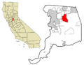
Map showing Rancho Cordova in Sacramento County
See also
 In Spanish: Rancho Cordova para niños
