Yolo Bypass facts for kids
Quick facts for kids Yolo Bypass |
|
|---|---|
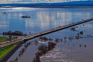
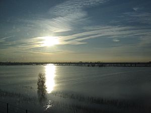
View of the flooded Yolo Bypass, looking southwest from West Sacramento (2017)
|
|
| Coordinates | 38°33′N 121°36′W / 38.55°N 121.60°W |
| Country | United States |
| State(s) | California |
| Characteristics | |
| Area | 59,000 acres (24,000 ha) |
| Hydrology | |
| River(s) | Sacramento, San Joaquin, American |
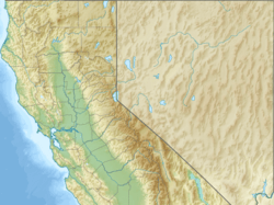
The Yolo Bypass is a special area in California that helps control floods. It is located in Yolo and Solano Counties. Think of it as a giant overflow channel for the Sacramento River.
When the Sacramento River gets too full, especially during heavy rains, the Yolo Bypass steps in. It uses a system of gates called weirs to move extra water away. This protects cities like Sacramento from flooding.
During very wet years, the bypass can fill up with water. The main way water enters is through the Fremont Weir. Water flows into the bypass if the river reaches a certain level. Another gate, the Sacramento Weir, can also be opened if more water needs to be diverted.
Water from Cache Creek also flows into the bypass from the west. The bypass then runs south, next to the Sacramento River. Finally, it drains into the Sacramento-San Joaquin Delta, near Rio Vista.
Two major highways cross the bypass. The Yolo Causeway carries Interstate 80 between West Sacramento and Davis. Further north, Interstate 5 crosses on the Elkhorn Causeway, near Woodland.
Contents
A Look Back: History of the Yolo Bypass
Before the Yolo Bypass was built, Sacramento faced many serious floods. The Yolo Basin, a natural dip in the land, would fill with water every winter. This happened because of seasonal rain and water flowing from the Sacramento, San Joaquin, and American rivers.
This created a huge marshland that could stay flooded for months. In the 1800s, these floods made it hard to travel between cities in the Sacramento River valley.
Big floods in 1862 and 1878 showed that something needed to be done. People started building things like the Tule Canal and the Elkhorn Weir to try and control the water.
In 1911, the government approved a big plan called the Sacramento River Flood Control Project. This plan aimed to use weirs and bypasses to move floodwaters safely. The Yolo Bypass is one of two main bypasses in the Sacramento Valley that helps prevent city floods. The other is the Sutter Bypass, located upstream.
The US Army Corps of Engineers designed the Yolo Bypass in the early 1930s. It covers about 59,000 acres (24,000 ha) and sits between Yolo and Solano Counties.
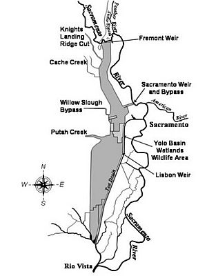
The Yolo Bypass is about 41 miles (66 km) long from north to south and 3 miles (4.8 km) wide. Its edges are marked by levees, which are like long walls, set far apart. The two biggest ways water enters the bypass are the Sacramento Weir, built in 1916, and the Fremont Weir, finished in 1929.
Why the Yolo Bypass is Important
Most of the Yolo Bypass land is privately owned, but a large part is the Yolo Bypass Wildlife Area. Farmers use much of the land for crops in summer and spring. The rest is marshland, which is a great home for animals. People also use it for fishing, hunting, and other fun activities.
Keeping Floods Away
The main job of the Yolo Bypass is to control floods. When the Sacramento River's water flow gets too high, the extra water goes into the Yolo Bypass at the Fremont Weir. This weir is about 33.5 feet (10.2 m) tall. When the water reaches about 12 feet (3.7 m) high, it starts to spill into the Yolo Basin.
North of the Elkhorn Causeway, water from the Cache Creek flood control basin also drains into the Yolo Bypass.
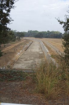
There's another weir called the Sacramento Weir, just north of West Sacramento. This weir is opened by hand when the Sacramento River reaches a certain height. It was built in 1916 and has 48 gates. Water from this weir flows through the Sacramento Bypass and into the Yolo Bypass.
| Name | Location | Capacity | Notes |
|---|---|---|---|
| Fremont Weir | 8 miles (13 km) NE of Woodland 15 miles (24 km) NW of Sacramento |
343,000 cu ft/s 583,000 m3/min |
Releases water from the Sacramento River |
| Sacramento Weir & Bypass | West Sacramento 4 miles (6.4 km) N of Tower Bridge |
112,000 cu ft/s 190,000 m3/min |
The only weir in the Yolo Bypass system that is opened manually |
| Cache Creek Settling Basin & Weir | 2 miles (3.2 km) E of Woodland | 30,000 cu ft/s 51,000 m3/min |
Covers 3,600 acres (1,500 ha) |
Water flowing through the Yolo Bypass eventually drains into the Sacramento-San Joaquin Delta. From there, it flows into San Francisco Bay.
The Yolo Bypass can hold about four times the amount of water as the Sacramento River itself. Together, they can handle a huge amount of water during floods. This helps protect cities like Sacramento and Davis from getting flooded. In wet years, which happen more than half the time, the Yolo Bypass floods. When it floods, it covers an area about one-third the size of San Francisco and San Pablo Bays, with water 6 to 10 feet (1.8 to 3.0 m) deep.
The state of California has the right to flood land in the Yolo Bypass. This means landowners cannot build things or grow plants that would block the water flow. Farmers do not get paid if their crops are lost due to flooding. The state tries to manage the flooding in a way that helps both farmers and wildlife.
Amazing Animals and Plants
The Yolo Bypass is home to several wildlife areas, including the Fremont Weir Wildlife Area and the Yolo Bypass Wildlife Area. The Vic Fazio Yolo Wildlife Area is part of this and was a huge project to bring back natural habitats. When the bypass floods in winter and spring, it becomes a valuable wetland for many animals. In summer, areas outside the wildlife zones are used for farming.
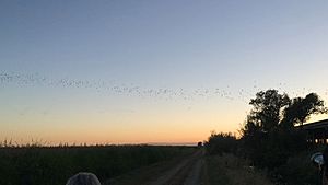
Over 280 different kinds of animals live in the Yolo Bypass, and the types of animals change with the seasons. The natural flooding is especially good for young fish, like the endangered Chinook salmon. Young salmon grow much better here than in the nearby Sacramento River.
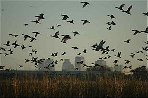
Other special animals found here include the giant garter snake, fairy shrimp, bald eagle, and Swainson's Hawk. Wildlife managers sometimes flood certain areas on purpose to create wetlands for migratory waterfowl (birds that travel long distances). The Yolo Bypass is like a rest stop for these birds, giving them places to nest and find food.
The Yolo Basin Wetlands Project is one of the biggest wetland restoration projects in the Western United States. The habitats here include seasonal wetlands, dry uplands, year-round wetlands, vernal pools (small, temporary ponds), and riparian forest (forests along rivers). The Bypass also has plants like cottonwoods, black walnut, willows, saltgrass, and other trees and grasses.
The California Department of Fish and Wildlife checks how the habitats are managed each year. They make plans for different parts of the land. For example, they focus on growing a plant called timothy in seasonal wetlands. This plant provides many seeds for migratory waterfowl to eat. There are also some plants that are not native to the area, like dock and perennial pepperweed, which are not wanted in the bypass.
When a lot of water flows through the Yolo Bypass, it also helps fish in the San Francisco Estuary. This is because there's more space for them, more food, and it helps young fish move around.
Growing Food
The floodplains of the Yolo Bypass are surprisingly good for farming many seasonal crops. The California Department of Fish and Wildlife rents out land to farmers. The most common crops grown here are rice, safflower, tomatoes, corn, sunflower, and irrigated pasture. Half of the rice grown is wild rice, which can handle colder weather.
Farming mostly happens in late spring and summer when the bypass usually isn't flooded. However, farming can be delayed if the water levels are still high.
Crops from Yolo County bring in about $300 million each year. Even after crops are harvested, the leftover plant parts are good for animals. They create places for animals to find food, like seeds for mourning doves and ring-necked pheasants.
Fun and Learning
The Yolo Bypass offers many ways to have fun and learn. The Yolo Bypass Wildlife Headquarters has summer programs for kids from kindergarten to high school. These programs include hands-on activities about plants, animals, and wetlands, using the Yolo Bypass Wildlife Area as a giant outdoor classroom. They have summer camps, classes, and welcome schools for field trips. The public can also take guided tours every month.
Many people visit the Yolo Bypass for bird watching, hunting, and hiking. You can hunt for waterfowl (when the bypass is flooded), ring-necked pheasants, and mourning doves. There are also trails around the wetlands that are open to everyone.
What's Next for the Bypass?
New studies suggest that letting more water into the Yolo Bypass could be good for animal habitats. There's a project planned to make the Yolo Bypass even bigger by moving the levees back. This would create more space for water to flow.
Also, the Bay Delta Conservation Plan includes ideas to help bring back fish habitats in the Yolo Bypass. One idea is to make a notch at the top of the Fremont Weir. This would allow more water to flow in, flooding the area more often, which is great for fish.
The Nigiri Project
The Nigiri Project is a special research study happening in the Yolo Bypass. It's a team effort by UC Davis, the California Department of Water Resources, and a group called California Trout.
This research looks at how floodplains, especially flooded rice fields, can be a home for endangered fish like the Chinook Salmon. In summer, these fields grow rice. But in winter, they can be flooded to create perfect wetland homes for salmon. They've been doing this experiment for four winters and have seen the fastest growth of young Chinook Salmon ever recorded in the Central Valley. The project tries to copy the natural yearly flood cycle of the Sacramento River, which most native fish used to rely on.
This project gets its funding from the U.S. Bureau of Reclamation, California Trout, and the California Department of Water Resources.
 | Audre Lorde |
 | John Berry Meachum |
 | Ferdinand Lee Barnett |


