
West Sacramento, California facts for kids
Quick facts for kids
West Sacramento, California
|
|
|---|---|
| City of West Sacramento | |

The Ziggurat Building on the Sacramento River in West Sacramento
|
|
| Nickname(s):
West Sac
|
|

Location in Yolo County and the state of California
|
|

West Sacramento, California
Location in California

West Sacramento, California
Location in the United States
|
|
| Country | United States |
| State | California |
| County | Yolo |
| Incorporated | January 1, 1987 |
| Area | |
| • Total | 22.80 sq mi (59.05 km2) |
| • Land | 21.47 sq mi (55.61 km2) |
| • Water | 1.33 sq mi (3.45 km2) 6.22% |
| Elevation | 20 ft (6 m) |
| Population
(2010)
|
|
| • Total | 48,744 |
| • Estimate
(2019)
|
53,519 |
| • Density | 2,492.73/sq mi (962.46/km2) |
| Time zone | UTC-8 (Pacific) |
| • Summer (DST) | UTC-7 (PDT) |
| ZIP code |
95691, 95605
|
| Area code(s) | 916 and 279 |
| FIPS code | 06-84816 |
| GNIS feature IDs | 1660149, 2412228 |
West Sacramento (also known as West Sac) is a city in Yolo County, California, United States. It's right across the Sacramento River from the city of Sacramento. The river also marks the border between Sacramento and Yolo counties.
West Sacramento is growing quickly! In 2020, about 53,915 people lived there. This was up from 48,744 people in 2010. For a long time, West Sacramento has been an important industrial area. Today, it has many different types of businesses. It's one of the top places for jobs in the region.
In 2014, the United States Conference of Mayors gave West Sacramento a special award. They named it the Most Livable City in America for cities with fewer than 100,000 people.
West Sacramento is part of a larger area called the Sacramento–Arden Arcade–Roseville Metropolitan Statistical Area. This whole area has a population of over 2 million people. Some of the main industries here are farming, government work, and transportation.
Contents
History of West Sacramento
Early Days and the Gold Rush
In 1844, a traveler from Europe named John Schwartz was the first to settle permanently in the West Sacramento area. At that time, this land was part of Mexico. He built a small house near the Sacramento River. John and his brother George started a business catching salmon. They also discovered the land was good for farming and raising animals.
In 1848, gold was found at Sutter's Mill. This brought many miners to the area. It was also when the Mexican–American War ended.
In 1846, a man named James McDowell bought land from John Schwartz. James, his wife Margaret, and their three daughters moved to the area now called Broderick. The Gold Rush brought a lot of danger. In 1849, James McDowell was killed.
Margaret McDowell needed to support her family. In October 1849, she hired someone to map out 160 acres of land. She divided it into blocks and called it the "Town of Washington." She sold the first piece of land for $500.
For the next ten years, the Town of Washington grew with new businesses and shipping. The California Steam Navigation Company came in 1859 because it was so close to the Sacramento River. There were also hotels, restaurants, and saloons for travelers. Many people traveling to Sacramento stopped in Washington to rest.
While Sacramento grew into a city, West Sacramento focused on farming. Fishing was very successful, with salmon, sturgeon, and other fish sent to markets in Sacramento and San Francisco. The rich soil also produced many crops like corn and sweet potatoes. The dairy industry also started here.
Mike Bryte was a famous dairy farmer. He came to California in 1849 to look for gold. He didn't get rich from gold, but he bought a dairy farm. He used steamships to send his dairy products to different markets. This helped him buy thousands of acres of land for farming and raising animals. Mike Bryte became an important person in the community. He was elected to the Yolo County Board of Supervisors and later became sheriff. In the 1900s, his land became the community of Bryte.
.jpg)
Becoming a City
Over time, the area continued to grow. The Town of Washington was renamed Broderick. This was to honor U.S. Senator David C. Broderick. After 1900, the three communities of Bryte, Broderick, and West Sacramento were known as "East Yolo."
From 1900 to 1920, the population of this area doubled. The West Sacramento post office opened in 1915. These communities officially became the City of West Sacramento in 1987.

The Port of West Sacramento
In June 1963, the Port of Sacramento opened for large ships. This happened after the Sacramento Deep Water Ship Channel was finished. The project started in 1949. It has since been renamed The Port of West Sacramento. The port mainly brings in cement and sends out rice.

Geography and Climate
West Sacramento is located at 38°34′50″N 121°31′49″W / 38.58056°N 121.53028°W.
The city covers about 22.8 square miles (59.05 square kilometers). Most of this is land, but about 1.4 square miles (3.45 square kilometers) is water.
West Sacramento is in Yolo County. The Sacramento River separates it from the city of Sacramento and Sacramento County. When West Sacramento became a city in 1987, it brought together three older communities: Broderick, Bryte, and the original West Sacramento area. It also includes the Southport area.
Southport makes up about half of the city's land. It used to have farms and small neighborhoods. But now, many new homes have been built there since the 1990s and 2000s. This has created new neighborhoods like Bridgeway and River Ranch.
West Sacramento's Climate


West Sacramento has a hot-summer Mediterranean climate. This means it has hot, dry summers and mild, wet winters.
| Climate data for West Sacramento, California | |||||||||||||
|---|---|---|---|---|---|---|---|---|---|---|---|---|---|
| Month | Jan | Feb | Mar | Apr | May | Jun | Jul | Aug | Sep | Oct | Nov | Dec | Year |
| Record high °F (°C) | 74 (23) |
79 (26) |
86 (30) |
95 (35) |
108 (42) |
113 (45) |
112 (44) |
110 (43) |
111 (44) |
101 (38) |
86 (30) |
78 (26) |
113 (45) |
| Mean daily maximum °F (°C) | 54 (12) |
61 (16) |
66 (19) |
73 (23) |
81 (27) |
88 (31) |
93 (34) |
92 (33) |
88 (31) |
79 (26) |
64 (18) |
55 (13) |
74 (23) |
| Mean daily minimum °F (°C) | 40 (4) |
43 (6) |
45 (7) |
48 (9) |
52 (11) |
57 (14) |
59 (15) |
59 (15) |
57 (14) |
51 (11) |
44 (7) |
39 (4) |
49 (9) |
| Record low °F (°C) | 19 (−7) |
21 (−6) |
24 (−4) |
30 (−1) |
34 (1) |
37 (3) |
43 (6) |
40 (4) |
37 (3) |
27 (−3) |
24 (−4) |
20 (−7) |
19 (−7) |
| Average precipitation inches (mm) | 4.06 (103) |
3.66 (93) |
2.98 (76) |
1.08 (27) |
0.55 (14) |
0.18 (4.6) |
0.05 (1.3) |
0.06 (1.5) |
0.35 (8.9) |
0.96 (24) |
2.38 (60) |
2.66 (68) |
18.97 (482) |
Businesses and Organizations
TV Stations and Newspapers
West Sacramento is home to two TV stations: KOVR (channel 13), which is a CBS station, and KMAX-TV (channel 31), an independent station. Both stations are owned by CBS and are located on KOVR Drive.
For news, you can read the News-Ledger and the West Sacramento Sun. These are weekly newspapers. The Sacramento Bee is also widely read in the city.
Sports in West Sac
Sutter Health Park is a major sports venue in West Sacramento. It's the home field for the Sacramento River Cats, a baseball team. It will also be the temporary home for the Athletics baseball team before they move to Las Vegas. The park used to be home to the Sacramento Mountain Lions football team.
West Sacramento also has the Sacramento Gold soccer team, which plays in the National Premier Soccer League.
California Highway Patrol Academy
The California Highway Patrol (CHP) Academy is located in West Sacramento. This is where new CHP officers are trained. There's also a CHP Museum on the same grounds.
Education in West Sacramento
Public Schools
The Washington Unified School District runs the public schools and programs in West Sacramento.
- Elementary schools:
* Bridgeway Island * Elkhorn * Riverbank * Southport * Stonegate * Westfield * Westmore Oaks
- High schools:
* River City High School
- Other programs:
* Independent Study * Preschool programs * Washington Adult School * Yolo Education Center * Bryte Career and College Training
- Charter schools:
* Washington Middle College High School
Other Schools and Colleges
- Sacramento Valley Charter School
- Heritage Peak Charter School
- Our Lady of Grace, WestSac (a private school)
- Lighthouse Charter School
- Sacramento City College, WestSac Center (a college campus)
In 2017, West Sacramento started the West Sacramento Home Run program. This program helps students by offering:
- Preschool for everyone
- Savings accounts for college for preschool graduates
- Internships with local businesses
- Free first year of college tuition for all West Sacramento high school graduates
Other Major Businesses
Raley's, a big grocery store chain, has its main office in West Sacramento.
The California State Teachers' Retirement System (CalSTRS) is also based here. This is a large pension fund for teachers. Its tall headquarters building is the tallest in the city.
In 2011, the mayor wanted to make West Sacramento a major center for food businesses. Because of this, several big international food companies have set up their US or North American offices and factories here. These include Nippon Shokken, Shinmei Foods, TOMRA, and Bayer Crop Science.
Top Employers in West Sacramento
Many people work in West Sacramento. Here are some of the biggest employers:
| # | Employer | Number of Employees |
|---|---|---|
| 1 | State of California, General Services | 1,960 |
| 2 | United States Postal Service | 1,605 |
| 3 | California State Teachers' Retirement System | 1,215 |
| 4 | United Parcel Service (UPS) | 1,182 |
| 5 | Xerox Healthcare | 900 |
| 6 | Washington Unified School District | 750 |
| 7 | Raley's/Bel Air | 634 |
| 8 | Tony's Fine Foods/United Natural Foods | 500 |
| 9 | Nor-Cal Beverage | 500 |
| 10 | Clark Pacific | 439 |
| 11 | Aetna Healthcare | 400 |
| 12 | ABM Janitorial | 400 |
| 13 | Hunter Douglas/Bytheways Inc. | 400 |
| 14 | Walmart | 391 |
| 15 | City of West Sacramento | 362 |
| 16 | Siemens Healthcare Diagnostics | 286 |
| 17 | IKEA | 256 |
| 18 | Farmers' Rice Cooperative | 250 |
| 19 | KOVR TV 13 | 231 |
| 20 | Idexx Veterinary Services | 171 |
| 21 | Target | 150 |
| 22 | The Home Depot | 103 |
| 23 | Lowe's Home Improvement | 100 |
Population and People
| Historical population | |||
|---|---|---|---|
| Census | Pop. | %± | |
| 1970 | 12,002 | — | |
| 1980 | 10,875 | −9.4% | |
| 1990 | 28,898 | 165.7% | |
| 2000 | 31,615 | 9.4% | |
| 2010 | 48,744 | 54.2% | |
| 2020 | 53,915 | 10.6% | |
| 2023 (est.) | 55,842 | 14.6% | |
| U.S. Decennial Census | |||
Population in 2010
In 2010, West Sacramento had a population of 48,744 people.
- About 60.6% of people were White.
- About 4.8% were African American.
- About 10.5% were Asian.
- About 31.4% of people were of Hispanic or Latino background.
Most people (99.3%) lived in homes. There were 17,421 households.
- About 38% of households had children under 18.
- The average household had 2.78 people.
The population was spread out by age:
- 26.7% were under 18 years old.
- 31.0% were between 25 and 44 years old.
- 9.8% were 65 years or older.
The average age in West Sacramento was 33.6 years.
Population in 2000
In 2000, the city had 31,615 people.
- About 64.99% of people were White.
- About 2.57% were African American.
- About 7.22% were Asian.
- About 29.95% of people were of Hispanic or Latino background.
There were 11,404 households.
- About 34.6% of households had children under 18.
- The average household had 2.75 people.
The average age was 34 years. The median income for a household was $31,718. About 22.3% of the population lived below the poverty line.
Getting Around West Sacramento
Public Transportation
West Sacramento has several ways to get around using public transport.
- Yolobus: This bus service runs every day in Yolo County and nearby areas. It connects West Sacramento to places like Davis, Woodland, downtown Sacramento, and the Sacramento International Airport.
- Sacramento Regional Transit (SacRT): This service offers buses and light rail trains in Sacramento and Sacramento County.
West Sacramento On-Demand
In 2018, West Sacramento started a special ride-sharing service called West Sacramento On-Demand. You can use a smartphone app or call to request a ride anywhere in the city.
- As of April 2020, rides cost $1.75 for seniors and people with disabilities.
- For everyone else, a ride costs $3.50.
- You can bring a friend for an extra $1.
- A weekly pass costs $15 and covers up to four rides per day.
Famous People from West Sacramento
- Christopher Cabaldon: He was the longest-serving Mayor of West Sacramento, from 1998 to 2020.
- Malcom Floyd: A professional football player (NFL Wide Receiver).
- Eugene Garin: A modern artist known for painting ocean scenes.
- Willie Jorrín: A former boxing champion (World Boxing Council super bantamweight).
- Burney Lamar: A NASCAR race car driver.
- Oleg Maskaev: A former boxing champion (World Boxing Council heavyweight).
- Steve Sax: A former professional baseball player (LA Dodgers 2nd baseman).
- Jamil Jan Kochai: An author.
Images for kids
-
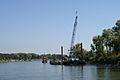
Sacramento River bank stabilization project in the city (2006).
-
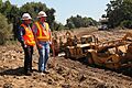
U.S. Army Corps of Engineers and the Central Valley Flood Protection Board working together to upgrade Sacramento River levees in West Sacramento (2011).
-
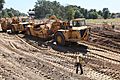
Crews building the new setback levee along South River Road in West Sacramento (2011).
-

The Corps of Engineers finishes the new paved setback levee in West Sacramento (2014).
-
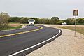
The completed setback levee, now used as South River Road in West Sacramento (2015).
.jpg)
.jpg)
.jpg)
.jpg)
.jpg)
See also
 In Spanish: West Sacramento para niños
