Auburn, California facts for kids
Quick facts for kids
Auburn, California
|
|||
|---|---|---|---|
| City of Auburn | |||

Auburn
|
|||
|
|||

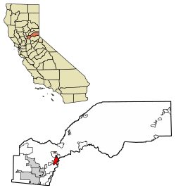
Location of Auburn in Placer County, California
|
|||
| Country | United States | ||
| State | California | ||
| County | Placer | ||
| Incorporated | May 2, 1888 | ||
| Government | |||
| • Type | Council–manager | ||
| Area | |||
| • City | 7.20 sq mi (18.66 km2) | ||
| • Land | 7.18 sq mi (18.59 km2) | ||
| • Water | 0.03 sq mi (0.07 km2) 0.38% | ||
| Elevation | 1,227 ft (374 m) | ||
| Population
(2020)
|
|||
| • City | 13,776 | ||
| • Density | 1,919.46/sq mi (741.10/km2) | ||
| • Metro | est. ~19,500 (including Foresthill Applegate and Meadow Vista) | ||
| Time zone | UTC−8 (Pacific Time Zone) | ||
| • Summer (DST) | UTC−7 (PDT) | ||
| ZIP codes |
95602-95604
|
||
| Area code(s) | 530 | ||
| FIPS code | 06-03204 | ||
| GNIS feature IDs | 1657964, 2409754 | ||
Auburn is a city in California, United States. It is the main city, or county seat, of Placer County. In 2020, about 13,776 people lived there. Auburn is famous for its role in the California Gold Rush and is recognized as a special historical place. It is also part of the larger Sacramento metropolitan area.
Contents
History of Auburn
Long ago, the Martis people lived in the Auburn area. Later, the Nisenan people, who were part of the Maidu tribe, made the first lasting settlement here.
In the spring of 1848, some French gold miners came to the area. They were on their way to the gold fields in Coloma, California. One of them, Claude Chana, found gold on May 16, 1848. Because they found so much gold, they decided to stay and mine.
The gold mining in Auburn was very good. The mining camp was first called the North Fork Dry Diggings. Later, it was called Woods Dry Diggings after a miner named John S. Wood built a cabin there. In August 1849, miners from Auburn, New York officially named the town Auburn. By 1850, about 1,500 people lived in Auburn. In 1851, Auburn became the county seat of Placer County.
In 1865, the Central Pacific Railroad reached Auburn. This was part of the First transcontinental railroad being built across the country.
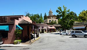
Today, the old part of Auburn, called Old Town, has buildings from the mid-1800s. You can see the oldest fire station and Post Office from the Gold Rush days. The Placer County Museum shows old gold-mining tools and items from Native American and Chinese cultures.
Auburn was also the home of Clark Ashton Smith, a famous writer and poet of science fiction and fantasy. There is a memorial for him near Old Town.
Where is Auburn Located?
Auburn is in the northern foothills of the Sierra Nevada mountains. It is about 800 feet (244 meters) above where the North Fork and Middle Fork of the American River meet.
The city covers about 7.2 square miles (18.66 square kilometers). Only a tiny part, about 0.03 square miles (0.07 square kilometers), is water.
Auburn is located between Sacramento and Reno, Nevada. You can find it along Interstate 80. To the east are mountain canyons and the Sierra Nevada. To the west are gentle hills good for farming. The main Sierra Nevada mountains are about 45 miles (72 km) east. The Central Valley is about 10 miles (16 km) to the west.
What is Auburn's Climate Like?
Auburn has a hot-summer Mediterranean climate. This means it has cool, wet winters and hot, dry summers.
- In December*, the average high temperature is about 55.8°F (13.2°C). The average low is about 37.2°F (2.9°C).
- In July*, the average high is about 92.7°F (33.7°C). The average low is about 63.4°F (17.4°C).
Each year, Auburn has about 63 days where the temperature reaches 90°F (32°C) or higher. About 7 days reach 100°F (38°C) or higher. It gets cold enough for freezing temperatures (32°F or 0°C) about 20 days a year. The hottest temperature ever recorded was 113°F (45°C) on July 15, 1972. The coldest was 5°F (-15°C) on December 9, 2013.
Auburn gets about 36.12 inches (917 mm) of rain each year. It rains on about 67 days. Snow rarely falls in Auburn. The most snow in one year was 10.7 inches (27 cm) in 1972.
Because of its climate, Auburn is a good place to grow grapes for wine. There are over 20 wineries in Auburn and the surrounding area.
| Climate data for Auburn, California, 1991–2020 normals, extremes 1905–present | |||||||||||||
|---|---|---|---|---|---|---|---|---|---|---|---|---|---|
| Month | Jan | Feb | Mar | Apr | May | Jun | Jul | Aug | Sep | Oct | Nov | Dec | Year |
| Record high °F (°C) | 81 (27) |
78 (26) |
93 (34) |
92 (33) |
102 (39) |
110 (43) |
113 (45) |
111 (44) |
109 (43) |
104 (40) |
89 (32) |
80 (27) |
113 (45) |
| Mean maximum °F (°C) | 65.3 (18.5) |
69.5 (20.8) |
75.3 (24.1) |
82.0 (27.8) |
89.8 (32.1) |
97.8 (36.6) |
100.9 (38.3) |
100.7 (38.2) |
96.4 (35.8) |
88.2 (31.2) |
75.8 (24.3) |
65.0 (18.3) |
102.8 (39.3) |
| Mean daily maximum °F (°C) | 55.1 (12.8) |
57.8 (14.3) |
61.9 (16.6) |
67.5 (19.7) |
75.9 (24.4) |
85.0 (29.4) |
91.7 (33.2) |
91.0 (32.8) |
86.8 (30.4) |
75.5 (24.2) |
62.8 (17.1) |
54.4 (12.4) |
72.1 (22.3) |
| Daily mean °F (°C) | 46.3 (7.9) |
48.1 (8.9) |
51.7 (10.9) |
55.7 (13.2) |
63.3 (17.4) |
71.2 (21.8) |
77.6 (25.3) |
76.9 (24.9) |
72.8 (22.7) |
63.6 (17.6) |
52.9 (11.6) |
45.4 (7.4) |
60.5 (15.8) |
| Mean daily minimum °F (°C) | 37.5 (3.1) |
38.7 (3.7) |
41.5 (5.3) |
44.0 (6.7) |
51.0 (10.6) |
57.5 (14.2) |
63.4 (17.4) |
62.8 (17.1) |
58.7 (14.8) |
51.6 (10.9) |
43.1 (6.2) |
36.8 (2.7) |
48.9 (9.4) |
| Mean minimum °F (°C) | 28.7 (−1.8) |
31.6 (−0.2) |
33.9 (1.1) |
35.8 (2.1) |
42.1 (5.6) |
47.4 (8.6) |
53.8 (12.1) |
53.7 (12.1) |
49.0 (9.4) |
41.4 (5.2) |
33.9 (1.1) |
27.4 (−2.6) |
25.6 (−3.6) |
| Record low °F (°C) | 17 (−8) |
20 (−7) |
20 (−7) |
24 (−4) |
25 (−4) |
30 (−1) |
36 (2) |
41 (5) |
34 (1) |
26 (−3) |
25 (−4) |
5 (−15) |
5 (−15) |
| Average precipitation inches (mm) | 7.01 (178) |
6.50 (165) |
6.12 (155) |
2.84 (72) |
1.65 (42) |
0.41 (10) |
0.01 (0.25) |
0.07 (1.8) |
0.24 (6.1) |
1.42 (36) |
3.05 (77) |
6.80 (173) |
36.12 (917) |
| Average snowfall inches (cm) | 0.4 (1.0) |
0.2 (0.51) |
0.2 (0.51) |
0.0 (0.0) |
0.0 (0.0) |
0.0 (0.0) |
0.0 (0.0) |
0.0 (0.0) |
0.0 (0.0) |
0.0 (0.0) |
0.1 (0.25) |
0.2 (0.51) |
1.1 (2.78) |
| Average precipitation days (≥ 0.01 in) | 10.7 | 10.3 | 9.2 | 6.6 | 5.0 | 2.0 | 0.2 | 0.4 | 1.4 | 3.2 | 7.0 | 11.0 | 67.0 |
| Source: NOAA | |||||||||||||
People Living in Auburn
| Historical population | |||
|---|---|---|---|
| Census | Pop. | %± | |
| 1860 | 814 | — | |
| 1870 | 800 | −1.7% | |
| 1880 | 1,229 | 53.6% | |
| 1890 | 1,595 | 29.8% | |
| 1900 | 2,050 | 28.5% | |
| 1910 | 2,376 | 15.9% | |
| 1920 | 2,289 | −3.7% | |
| 1930 | 2,661 | 16.3% | |
| 1940 | 5,013 | 88.4% | |
| 1950 | 4,653 | −7.2% | |
| 1960 | 5,586 | 20.1% | |
| 1970 | 6,570 | 17.6% | |
| 1980 | 7,540 | 14.8% | |
| 1990 | 10,592 | 40.5% | |
| 2000 | 12,462 | 17.7% | |
| 2010 | 13,330 | 7.0% | |
| 2020 | 13,776 | 3.3% | |
| U.S. Decennial Census | |||
The 2010 United States Census counted 13,330 people living in Auburn. Most people, about 89%, were White. Other groups included African American, Native American, Asian, and Pacific Islander people. About 10% of the population was Hispanic or Latino.
Most people (97.9%) lived in homes. About 26% of homes had children under 18. The average household had 2.27 people. The average family had 2.85 people.
The population included:
- 19.8% under 18 years old
- 7.7% aged 18 to 24
- 21.7% aged 25 to 44
- 31.7% aged 45 to 64
- 19.0% aged 65 or older
The average age in Auburn was 45.4 years. For every 100 females, there were about 89.5 males.
Most homes (58.8%) were owned by the people living in them. The rest (41.2%) were rented.
Fun Things to See and Do in Auburn
Famous Places in Auburn
Auburn is home to Placer High School, which is one of the oldest high schools in California.
You can find large sculptures around the town. These statues tell stories from Auburn's history. For example, there's a statue of Claude Chana gold panning in the American River. Another shows a Chinese worker building the Transcontinental Railroad.
Hidden Falls Regional Park is nearby. It has 30 miles (48 km) of trails for walking, biking, and horseback riding.
How to Get Around Auburn
Transportation in Auburn
Auburn has Amtrak passenger train service. Its train station is the end point for the Capitol Corridor train in California.
Interstate 80 is the main highway that goes through Auburn. It connects Sacramento to the west with the Lake Tahoe and Reno areas to the east. You can get into Auburn from several exits on Interstate 80.
California Highway 49 is the main north-south road. It links Auburn to towns like Grass Valley and Nevada City to the north. It also connects to Placerville to the south.
The Auburn Municipal Airport is about 3 miles (5 km) north of town. It is a small airport used for private planes, not big passenger jets. Auburn owns and runs this airport. It has one runway that is 3,700 feet (1,128 meters) long.
Famous People From Auburn
- Ben Nighthorse Campbell (born 1933): An Olympian in judo and a United States Senator.
- Jean-Baptiste Charbonneau (1805–1866): Son of Sacagawea, an explorer, and a hotel owner in Auburn.
- Stacy Dragila (born 1971): An Olympic gold medalist in pole vault.
- Jeff Hamilton (1966–2023): An Olympic bronze medalist and professional skier.
- Jo Hamilton (1827–1904): A lawyer who served as Attorney General of California.
- Kane Hodder (born 1955): A famous stuntman and actor.
- George Lynch (born 1954): A hard rock guitarist and songwriter.
- Isaiah Piñeiro (born 1995): A professional basketball player.
- Clark Ashton Smith (1893–1961): A well-known writer and artist.
See also
 In Spanish: Auburn (California) para niños
 | Toni Morrison |
 | Barack Obama |
 | Martin Luther King Jr. |
 | Ralph Bunche |


