
Yerba Buena Island facts for kids
Quick facts for kids
Yerba Buena Island
Isla de Alcatraces
|
|
|---|---|

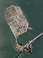
Yerba Buena Island with the San Francisco–Oakland Bay Bridge in the foreground
|
|

Yerba Buena Island
Location in San Francisco
|
|
| Country | United States |
| State | California |
| City | San Francisco |
Yerba Buena Island (which means Isla Yerba Buena in Spanish) is an island located in San Francisco Bay. It is part of the City and County of San Francisco. A special tunnel, the Yerba Buena Tunnel, goes through the middle of the island. This tunnel connects the two main parts of the San Francisco–Oakland Bay Bridge, linking San Francisco with Oakland, California.
The nearby Treasure Island is connected to Yerba Buena Island by a road called a causeway. Together, Yerba Buena Island and Treasure Island cover about 0.901 square miles (2.33 square kilometers) of land. In 2010, about 2,500 people lived on both islands.
Yerba Buena Island has been called by other names over time, such as Sea Bird Island, Wood Island, and Goat Island. The name "Yerba Buena" might come from a plant that grew a lot in the area. This plant, called Yerba buena, is a type of mint. Its Spanish name means 'good herb'.
Today, the southeastern part of Yerba Buena Island is a military area controlled by the United States Coast Guard (USCG). The Coast Guard uses the island for important tasks. For example, the Vessel Traffic Service (VTS) tower is on top of the island. This tower helps guide ships safely through the bay. The main office for the US Coast Guard in San Francisco is also on the island, along with a station for Coast Guard boats. They also have a place to fix navigational buoys, which are floating markers that help ships. Some senior Coast Guard officers live in houses on the island's hill.
Contents
Island History: From Ohlone to Today
Yerba Buena Island was once home to an Ohlone fishing village called Tuchayune.
Early Names of the Island
The island's name goes back to 1775, when it was called "Isla de Alcatraces" by Juan de Ayala. This means "island of the pelicans" because many pelicans lived there. Later, an English explorer named Frederick William Beechey moved the name "Alcatraz Island" to the famous rock where the prison now stands.
The name "la Ysla de la Yerba Buena" was used by early Spanish settlers around 1795. Yerba buena refers to many fragrant plants. Here, it meant a native plant called Clinopodium douglasii, which smelled like spearmint and grew a lot around the bay. It's not clear if the island was named directly after the plant or after a nearby cove and settlement also called Yerba Buena.
The island was officially called Yerba Buena Island until 1895. Then, the United States Board on Geographic Names changed its name to Goat Island. This happened because many goats were kept on the island during the Gold Rush. The name "Goat Island" became very popular. However, on June 3, 1931, the name was changed back to Yerba Buena Island.
Military Presence on the Island
The idea of having a military base on Yerba Buena Island started during the American Civil War. People were worried that enemy warships might sneak past Fort Point and Alcatraz Island in foggy weather.
In the 1870s, an Army post was built on the island. This included a fog signal and an eight-sided lighthouse called Yerba Buena Light, which still stands today. In 1891, the United States Army Corps of Engineers built a Torpedo Station. The "torpedoes" were actually floating mines that could be placed in the bay to protect against enemy ships. This station was no longer used in the 1930s, but the building is still there, hidden under the San Francisco-Oakland Bay Bridge. It is listed in the National Register of Historic Places because of its history.
Just before the 1900s, the first U.S. Naval Training Station on the Pacific Coast was set up on the island. One important house, called Quarters One (also known as the Admiral Nimitz House), was built around 1900 for the commander of the Naval Training Station. This house is one of eight old officers' homes still standing. It has a Classic Revival style, which was popular for homes in the Bay Area at the time. In 1963, Admiral Nimitz and his wife moved into this house, and he passed away there in 1966.
The training station closed after World War I. However, the Navy still used the island. During World War II, Yerba Buena Island was part of the Treasure Island Naval Station. Treasure Island was built on the shallow waters next to Yerba Buena Island in the 1930s. After hosting a big fair in 1939, the United States Navy realized Treasure Island was perfect for moving people and equipment to the Pacific theater. So, in 1942, they set up the Treasure Island Naval Station, which included part of Yerba Buena Island. Quarters One became the home of the Commander, U.S. Pacific Fleet. Many other buildings used by the Navy during World War II are still on the island.
In 1996, the naval base was closed, and the island became open to public control. The San Francisco Police Department (SFPD) now handles law enforcement for most of Yerba Buena Island, except for the Coast Guard areas. The San Francisco Fire Department (SFFD) provides fire protection and medical help for Yerba Buena Island and parts of the San Francisco–Oakland Bay Bridge.

Interesting Places on the Island
West of the island was a dangerous underwater rock called "Blossom Rock." It was only 5 feet (1.5 meters) below the water's surface at low tide. Captain Beechey discovered it in 1826. He noted that ships could avoid it by lining up the northern tip of Yerba Buena Island with two large redwood trees on the Oakland hills. These "Navigation Trees" were cut down around 1851, making Blossom Rock even more dangerous. The top of the rock was blown up in 1870, and more was removed in the early 1930s.
Yerba Buena Island has three parks: Hill Park, Blue Park, and Tower Park. Hill Park used to be a military cemetery, but the graves were moved to the San Francisco National Cemetery in the Presidio of San Francisco when the 1939 Golden Gate International Exposition needed a clear approach road.
Two water reservoirs on the island store water for the island's use and for fire hydrants.
Island Population and Development
In 2007, after the City of San Francisco took control of the island from the U.S. Navy, about 40 families (around 100 people) lived there.
In 2011, the San Francisco Board of Supervisors approved a plan to develop the island over 20 years. The goal is to build two new neighborhoods with up to 8,000 homes. A quarter of these homes are planned to be affordable housing.
In 2015, most residents were asked to move to make way for the new buildings. They were offered about $5,000 to move off the island or an apartment on Treasure Island. About two-thirds of the residents chose to move to Treasure Island. As of 2023, a complex with 124 condos called "The Bristol" has opened, along with an affordable apartment building for veterans. Many other planned developments have been delayed by lawsuits. A tall sundial and sculpture by Hiroshi Sugimoto opened on a Yerba Buena hilltop in June 2023.
In Popular Culture
In his book Two Years Before the Mast, published in 1840, Richard Henry Dana, Jr. wrote about his ship anchoring "between a small island, called Yerba Buena, and a gravel beach in a little bight or cove of the same name."
Images for kids
-
Aerial photo of Treasure Island (top) and Yerba Buena Island (bottom).

See also
 In Spanish: Isla de Yerba Buena para niños
