
San Francisco–Oakland Bay Bridge facts for kids
Quick facts for kids San Francisco–OaklandBay Bridge |
|
|---|---|

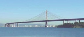
The western section of the bridge, seen in 2022. Part of the eastern section can be seen beyond Yerba Buena Island to the left.
|
|
| Coordinates | 37°49′5″N 122°20′48″W / 37.81806°N 122.34667°W |
| Carries |
|
| Crosses | San Francisco Bay via YBI |
| Locale | San Francisco and Oakland, California, U.S. |
| Owner | State of California |
| Maintained by | California Department of Transportation and the Bay Area Toll Authority |
| ID number |
|
| Characteristics | |
| Design | Double-decked suspension spans (two, connected by center anchorage), tunnel, cast-in-place concrete transition span, self-anchored suspension span, precast segmental concrete viaduct |
| Material | Steel, concrete |
| Total length | West: 10,304 ft (3,141 m) East span: 10,176 ft (3,102 m) Total: 4.46 miles (7.18 km) excluding approaches |
| Width | West: 5 traffic lanes totaling 57.5 ft (17.5 m) East: 10 traffic lanes totaling 258.33 ft (78.74 m) |
| Height | West: 526 ft (160 m) East: 525 ft (160 m) (SAS) |
| Longest span | West: two main spans 2,310 ft (704 m) East: one main span 1,400 ft (430 m) |
| Clearance above | Westbound: 14 feet (4.3 m), with additional clearance in some lanes Eastbound: 14.67 feet (4.47 m) |
| Clearance below | West: 220 feet (67 m) East: 190 feet (58 m) |
| History | |
| Designer | Charles H. Purcell |
| Construction begin | July 8, 1933 (original eastern and western spans) January 29, 2002 (replacement eastern span) |
| Construction end | November 12, 1936 (original eastern and western spans) September 2, 2013 (replacement eastern span) |
| Opened | November 12, 1936 September 2, 2013 |
| Closed | August 28, 2013 (original eastern span) |
| Statistics | |
| Daily traffic | 260,000 |
| Toll |
|
| Designated: | August 13, 2001 |
| Reference #: | 00000525 |
The San Francisco–Oakland Bay Bridge, often called the Bay Bridge, is a huge set of bridges that crosses San Francisco Bay in California. It's a key part of Interstate 80, connecting San Francisco and Oakland. Every day, about 260,000 vehicles use its two levels. This bridge includes one of the longest bridge sections in the United States.
People first thought about building this toll bridge during the California gold rush in the 1850s. A famous local figure, "Emperor" Joshua Norton, even suggested it. However, construction didn't start until 1933. Charles H. Purcell designed the bridge, and the American Bridge Company built it. It opened on November 12, 1936, a few months before the Golden Gate Bridge.
Originally, the top deck was for cars, while the bottom deck carried trucks, buses, and commuter trains. After the Key System stopped its train service in 1958, the lower deck was also changed to carry only road traffic. In 1963, traffic was reorganized: the upper deck became for westbound traffic, and the lower deck for eastbound traffic. Trucks and buses were allowed on both decks.
In 1986, the bridge was unofficially named the James Rolph Jr. Bridge, after a former Governor of California.
The Bay Bridge has two main parts, each about the same length. The older western part, officially called the Willie L. Brown Jr. Bridge, connects downtown San Francisco to Yerba Buena Island. The newer eastern part connects the island to Oakland. The western part is a double suspension bridge with two decks. The eastern part was rebuilt after an earthquake and is now a single deck.
During the 1989 Loma Prieta earthquake, a section of the old eastern part of the bridge collapsed. The bridge was closed for a month for repairs. A new eastern section was built, starting in 2002, and opened on September 2, 2013. This new section cost over $6.5 billion. The old eastern section was completely taken down by 2018.
Contents
- Bridge Design and Features
- Bridge's Early Days
- Opening Day Excitement
- Bridge History After Opening
- The Bridge Railway
- Emperor Norton's Plaque
- Roadway Changes
- Yerba Buena Tunnel Updates
- 1968 Plane Crash
- Lights on the Cables
- Willie L. Brown, Jr., Bridge Naming
- 1989 Earthquake and Repairs
- Bridge Security Measures
- Western Span Earthquake Upgrades
- 2007 Oil Spill
- 2009 Eyebar Crack and Closure
- Eastern Span Replacement Project
- The Bay Lights Art Installation
- Alexander Zuckermann Bike Path
- Yerba Buena Tunnel Repairs
- Bus Lane Proposal
- Judge John Sutter Regional Shoreline
- Exit and Entrance Changes
- Bridge Costs and Tolls
- Images for kids
- See also
Bridge Design and Features

The Bay Bridge is made of two main crossings, one on each side of Yerba Buena Island. This island is a natural piece of land in the middle of San Francisco Bay.
The western crossing goes between Yerba Buena Island and downtown San Francisco. It has two full suspension bridge sections connected in the middle. Rincon Hill in San Francisco is where the western part of the bridge touches down.
The eastern crossing connects Yerba Buena Island to Oakland. The original eastern crossing was a cantilever bridge. But because of earthquake worries, a new eastern crossing was built and opened in 2013.
On Yerba Buena Island, the bridge goes through a 540-foot (160 m) long Yerba Buena Tunnel. This tunnel goes through the island's rocky center.
Toll Plaza and Traffic Flow
The toll plaza is on the Oakland side of the bridge. You only pay a toll when you are driving westbound (towards San Francisco). There are eighteen toll lanes. You can pay using FasTrak (an electronic system) or by mail based on your license plate. Cash is not accepted.
Traffic lights, called metering signals, are about 1,000 feet (300 m) west of the toll plaza. These help control how many cars get onto the bridge. There are special lanes for buses and carpools during busy times.
Traffic can get very heavy, especially during morning commutes from Oakland to San Francisco. Backups also happen in the evenings for eastbound traffic from San Francisco. The problem isn't the bridge itself, but the roads leading up to it.
Bike and Pedestrian Access
The western part of the Bay Bridge is only for cars and trucks. People cannot walk or bike across it. There have been ideas to add bike and pedestrian lanes to this section.
However, the new eastern section of the bridge has a special path for bikes and pedestrians. This path connects Oakland to Yerba Buena Island.
You can get to Yerba Buena Island and Treasure Island using freeway ramps near the tunnel. Since the toll is only on the Oakland side, you can drive between Yerba Buena Island and San Francisco without paying a toll. But if you drive from Oakland to Yerba Buena Island, you still pay the full toll.
Bridge's Early Days
San Francisco grew quickly during the California Gold Rush. Most goods arrived by ship, but after the first transcontinental railroad was finished in 1869, San Francisco was on the wrong side of the bay. It was separated from the new train lines.
Many people in San Francisco worried that their city would lose its importance. Business leaders had thought about a bridge across San Francisco Bay since the Gold Rush. In the 1870s, newspapers discussed the idea.
Emperor Norton's Vision

A unique San Francisco figure, Emperor Norton, famously ordered three times in 1872 that a suspension bridge be built. He wanted it to connect Oakland with San Francisco, going through Yerba Buena Island. He even threatened to arrest city leaders if they didn't follow his orders!
Unlike some of his other unusual ideas, the bridge idea was popular. But building such a bridge was a huge challenge for engineers and financially. The bay was too wide and too deep. In 1921, people thought about an underground tunnel, but it wouldn't be big enough for cars. As more people owned cars, support for a bridge grew in the 1920s.
Planning the Bridge

In 1929, California leaders passed a law to create the California Toll Bridge Authority. This group was tasked with building a bridge between San Francisco and Alameda County.
A special group, the Hoover-Young Commission, studied the idea and different designs. Their findings were shared in 1930.
In 1931, Charles H. Purcell became the Chief Engineer for the Bay Bridge project. He and his team had to invent new designs and engineering ideas for parts of the bridge.
To make the bridge possible, they chose a route through Yerba Buena Island. This would save on materials and labor. Since the island was a U.S. Navy base, California needed permission from the U.S. Congress. After much effort, Congress approved using the island in 1931.
Building the Bay Bridge

Before construction began, 12 large underwater telephone cables were moved in 1931.
Construction officially started on July 9, 1933. Former President Herbert Hoover and other important people attended the groundbreaking ceremony.
The western part of the bridge was a huge engineering challenge. The bay was up to 100 feet (30 m) deep. Engineers had to invent new ways to lay foundations. They decided to build a massive concrete anchor halfway between San Francisco and the island. Then, they built a main suspension bridge section on each side of this anchor.
East of Yerba Buena Island, the bridge to Oakland was a 10,176-foot (3.102 km) long mix of different bridge types. This included a double cantilever section, which was the longest in the nation at the time.
Many parts of the original eastern section were built on wooden poles driven deep into the bay mud. These poles were made from large Douglas fir trees. Building the bridge was dangerous work, and twenty-four workers died during its construction.
Yerba Buena Tunnel

Charles H. Purcell, the chief engineer, also oversaw the building of the Yerba Buena Tunnel. Before digging, the ground was made stronger by injecting cement into the loose rock.
Workers dug three smaller tunnels first, then removed the space between them. This created a large arch-shaped tunnel. Steel beams and thick concrete were used to support the tunnel roof. No cave-ins happened during the digging.
After the roof was done, the remaining rock was removed. The upper deck was then put in place, and the tunnel's ceiling was lined with tiles. The last concrete for the Bay Bridge was poured in the tunnel in 1936.
The tunnel is 76 feet (23 m) wide, 58 feet (18 m) high, and 540 feet (160 m) long. In 1936, it was the largest tunnel of its kind in the world. The rock dug out from the tunnel was used to create Treasure Island.
The Yerba Buena Tunnel opened with the rest of the Bay Bridge on November 12, 1936. It still doesn't have an official name today.
Opening Day Excitement
The bridge opened on November 12, 1936, at 12:30 p.m. Many important people were there, including former U.S. President Herbert Hoover. Governor Frank Merriam officially opened the bridge by cutting gold chains with a special torch.

Newspapers reported huge crowds and traffic jams as everyone wanted to see the new bridge. The San Francisco Chronicle described it as "the greatest traffic jam in the history of S.F." Thousands of people tried to drive across or view the brightly lit bridge and fireworks.
The total cost of the bridge was about $77 million. Before opening, it was blessed by Cardinal Secretary of State Eugene Cardinal Pacelli, who later became Pope Pius XII. Because it was like two bridges joined together, its western sections were among the largest suspension bridges in the world.
To celebrate, the San Francisco Mint made a special half-dollar coin. It showed California's grizzly bear on one side and the bridge on the other.
Bridge History After Opening
The Bridge Railway

Work on the Bridge Railway, which carried trains, started in 1937. The first test train crossed the bridge on September 23, 1938. Regular train service began on January 15, 1939, using the south side of the bridge's lower deck.
.jpg)
Trains were run by different companies like the Sacramento Northern Railroad and the Key System. Freight trains never used the bridge. There was even a stop at Yerba Buena Island starting in 1942.
However, fewer people were riding the trains. The last train crossed the bridge in April 1958. The tracks were removed and replaced with pavement for cars and buses. Today, AC Transit buses still use the bridge to a new transit center in San Francisco.
Emperor Norton's Plaque
In 1939, a plaque honoring Emperor Norton for his early idea of the Bay Bridge was created. It was installed at The Cliff House in 1955. In 1986, for the bridge's 50th anniversary, the plaque moved to the Transbay Terminal. When that terminal closed in 2010, the plaque was stored. It was placed at the Salesforce Transit Center in 2019 but was later damaged. After being restored, it is now displayed in a bar called Molloy's Tavern.
Roadway Changes
Until the 1960s, the upper deck had six lanes for cars only. The lower deck had three lanes for trucks and buses, plus two train tracks. In 1958, the train tracks were removed. By 1963, the bridge was reconfigured: the upper deck became five lanes for westbound traffic, and the lower deck became five lanes for eastbound traffic. Trucks and buses were then allowed on both decks.
The bridge was renamed Interstate 80 in 1964.

Yerba Buena Tunnel Updates
When first built, the tunnel's upper deck had six lanes for cars. The lower deck had three lanes for trucks and two train tracks. After the trains stopped running in 1958, the tunnel was rebuilt.
The train tracks were removed, and the lower deck was lowered. The center columns supporting the upper deck were taken out. The upper deck itself was lowered to allow tall trucks to use it. After these changes, both decks could carry five lanes of traffic. The upper deck became for westbound traffic, and the lower deck for eastbound.
This reconstruction was done carefully to minimize traffic problems. It was completed in 1962.
1968 Plane Crash
On February 11, 1968, a U.S. Navy training plane crashed into the bridge's eastern section. Both officers on board died. The plane hit the bridge about 15 feet (5 m) above the upper deck. No drivers on the bridge were hurt. Part of the bridge was replaced due to the damage.
Lights on the Cables
In 1986, lights were added to the suspension cables of the western span. This was part of the bridge's 50th-anniversary celebration.
Willie L. Brown, Jr., Bridge Naming
The western section of the bridge is officially named the Willie L. Brown, Jr., Bridge. This honors Willie Brown, a former Mayor of San Francisco and Speaker of the California State Assembly. Signs were put up in 2014.
1989 Earthquake and Repairs

On October 17, 1989, a strong earthquake, called the Loma Prieta earthquake, hit the area. A 50-foot (15 m) section of the old eastern part of the bridge's upper deck fell onto the lower deck. One person died indirectly because of this. The bridge was closed for over a month while crews repaired the damaged section. It reopened on November 18, 1989.
Bridge Security Measures
In 2001, after the September 11 attacks, there was a concern about possible threats to bridges. Security was increased, and special work was done to make the bridge stronger against potential damage. No attack occurred.
Western Span Earthquake Upgrades
.jpg)
The western section of the bridge has had many upgrades to make it safer during earthquakes. Much of the steel that supports the bridge deck was replaced while the bridge was still open to traffic.
Many old rivets were replaced with stronger bolts. Concrete supports were also strengthened. Engineers used special techniques to add more steel bars and concrete to these supports. This work made the bridge much more resistant to earthquakes.
2007 Oil Spill
In 2007, a container ship named the Cosco Busan hit part of the bridge. This caused the Cosco Busan oil spill in the bay.
2009 Eyebar Crack and Closure
In 2009, a large crack was found in a metal part called an eyebar on the eastern section. This caused the bridge to close for repairs. Later, a steel crossbeam and two tie rods broke off and fell onto the upper deck. Three cars were hit, but no one was hurt. The bridge closed again for more repairs and reopened on November 2, 2009.
Eastern Span Replacement Project
Engineers decided it would be too expensive to fix the old eastern section of the bridge to make it earthquake-safe. So, they chose to replace it entirely.
The new eastern section has a unique design with a single tower and a self-anchored suspension span. It also has a long, sloping viaduct leading to Oakland.
A special path for bikes and pedestrians is a noticeable feature on the south side of the new eastern section. This path, called the Alexander Zuckermann Bike Path, opened in October 2016. It allows cyclists and walkers to travel between Oakland and Yerba Buena Island.
The old eastern section closed permanently on August 28, 2013. The new replacement span opened just five days later. The old section was taken down between 2014 and 2017.
- Eastern span: original and replacement
-
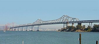
Some new construction (2004)
-
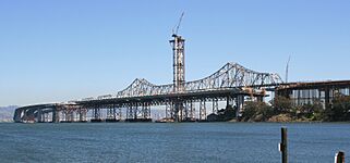
Substantial progress (2011)
-
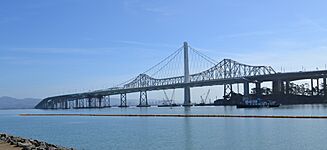
The completed replacement and the old bridge (2013)
-
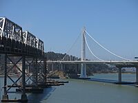
Rest of old and new bridge (June 2015)
-
Artist's simulation of final appearance after old span demolition


The Bay Lights Art Installation

On March 5, 2013, a public art project called "The Bay Lights" was turned on. It was on the vertical cables of the western span. Artist Leo Villareal designed the installation, which had 25,000 LED lights. The lights showed different patterns like rainfall or bird flight.
The lights were originally planned to be temporary. However, enough money was raised to make them permanent. They were turned off for maintenance in March 2015 and then re-lit on January 30, 2016. To avoid distracting drivers, the lights were only visible from a distance, not from the bridge itself.
The lights were permanently switched off on March 5, 2023, after 10 years. This was because they were in poor condition and cost too much to maintain. There are plans to install new lights in the future.
Alexander Zuckermann Bike Path
The bike and pedestrian path on the eastern section of the bridge opened on September 3, 2013. It is named after Alexander Zuckermann, who helped start the East Bay Bicycle Coalition. This path is part of the San Francisco Bay Trail.
The path now fully connects Oakland to Yerba Buena Island. It is open seven days a week, from 6 a.m. to 9 p.m., though it sometimes closes for maintenance.
Yerba Buena Tunnel Repairs
On January 30, 2016, a piece of concrete fell from the Yerba Buena Tunnel wall onto the lower deck. This caused a minor accident. Engineers found other spots in the tunnel showing signs of damage. It seemed that rainwater leaking from the upper deck drains caused the steel inside the concrete to rust and expand.
Repairs to the concrete started in February 2017. Drains were replaced, and special mortar was used to patch the walls.
Bus Lane Proposal
In 2020, there were proposals to create special bus lanes on the bridge. This would help buses move faster and reduce traffic.
Judge John Sutter Regional Shoreline
A new park, Judge John Sutter Regional Shoreline, opened on October 21, 2020. It is located at the foot of the bridge and makes it easier for people to access the Alexander Zuckermann Bike Path.
Exit and Entrance Changes
Over the years, the ramps for getting on and off Yerba Buena Island and Treasure Island have changed. Some older exits were considered dangerous because drivers had to slow down quickly.
New ramps have been built to improve safety and traffic flow. For example, a new westbound off-ramp opened in 2016. More changes to the ramps are planned to make them safer and more efficient.
Bridge Costs and Tolls
Current Toll Rates

You only pay a toll when driving westbound (towards San Francisco) at the toll plaza in Oakland. If you travel only between Yerba Buena Island and San Francisco, there is no toll.
Since 2020, all tolls are collected electronically. You can use a FasTrak device or pay based on your license plate. You still need to slow down when passing through the toll plaza.
As of January 1, 2025, the toll for cars is $8. During busy weekday hours (5:00 a.m. to 10:00 a.m. and 3:00 p.m. to 7:00 p.m.), carpools with three or more people, clean air vehicles, or motorcycles pay a discounted toll of $4 if they use FasTrak. If you don't have FasTrak or a license plate account, you must pay online within 48 hours to avoid extra fees.
Past Toll Rates
When the Bay Bridge first opened in 1936, the toll was 65 cents in each direction. It was later lowered to 25 cents to compete with ferries.
In 1969, the policy changed. Tolls were only collected from westbound traffic, but at twice the previous rate. Eastbound vehicles became free.
Tolls increased over time to pay for bridge improvements and to support public transportation. For example, a $1 surcharge was added in 1998 for earthquake safety upgrades.
In 2010, a special pricing system was started for the Bay Bridge. During peak weekday hours, the toll was $6, while at other times and on weekends it was $5. Carpools also started paying a discounted toll of $2.50. This system helped reduce traffic jams during busy times.
In 2018, voters approved Regional Measure 3, which raised tolls again. The tolls increased by $1 in 2019 and another $1 in 2022. The next increase will be on January 1, 2025.
In 2019, the Metropolitan Transportation Commission decided to remove toll takers and make all seven state-owned bridges fully electronic. This change happened on March 20, 2020, sped up by the COVID-19 pandemic.
The Bay Area Toll Authority approved plans in December 2024 for 50-cent annual toll increases from 2026 to 2030 to help with bridge maintenance. By 2030, the standard toll for cars will be $10.50. There will also be small extra fees for paying by license plate or for late payments.
Images for kids
-
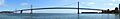
Panorama showing the western span, 2007
-
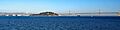
Panorama showing the Bay Bridge with the new eastern span, 2017
See also
 In Spanish: Puente de la Bahía de San Francisco a Oakland para niños
- 49-Mile Scenic Drive
- Bay Bridge Troll
- Cosco Busan oil spill
- Golden Gate Bridge
- List of bridges documented by the Historic American Engineering Record in California
- Southern Crossing (California) - proposed parallel bridge
- Treasure Island Development
- 25 de Abril Bridge, a bridge with a similar design in Portugal
