
Embarcadero (San Francisco) facts for kids

The Embarcadero photographed from southeast, with the Ferry Building to the right and Alcatraz Island in the distance.
|
|
| Maintained by | San Francisco DPW |
|---|---|
| Nearest metro station | |
| Southeast end | Second and King Streets |
| Major junctions |
|
| Northwest end | Pier 45 |
|
Central Embarcadero Piers Historic District
|
|
| Location | Piers 1, 1½, 3 and 5, The Embarcadero San Francisco, California |
| Area | 6.6 acres (2.7 ha) |
| Built | 1918 |
| Architectural style | Beaux Arts |
| NRHP reference No. | 02001390 |
| Added to NRHP | November 20, 2002 |

The Embarcadero is a famous road and waterfront area in San Francisco, California. Its name comes from the Spanish word embarcar, which means "to embark" or "to go on a ship." So, Embarcadero means "the place to get on a ship."
This area was built on reclaimed land, which means land that was once water but was filled in. It runs along a three-mile-long seawall, with piers reaching out into the bay. The Central Embarcadero Piers Historic District was added to the National Register of Historic Places in 2002 because of its importance.
The Embarcadero starts near Oracle Park at Second and King Streets. It then goes north, passing under the San Francisco–Oakland Bay Bridge. It continues past the famous Ferry Building at Market Street, then Pier 39, and Fisherman's Wharf. It finally ends at Pier 45. Part of The Embarcadero was once called East Street.
For about 30 years, a large highway called the Embarcadero Freeway stood over this area. It was taken down in 1991. After the freeway was gone, the area was rebuilt and improved. This made the waterfront a lively and important part of the city again.
Contents
History of the Waterfront
San Francisco's original shoreline was different from today. It had an inlet called Yerba Buena Cove. As the city grew, people filled in this cove. Over 50 years, a large seawall was built offshore, and the muddy areas were filled in. This created the land where San Francisco's Financial District now stands.
The San Francisco Belt Railroad, a short train line for cargo, used to run along The Embarcadero. Its old engine house is still there today. The road itself follows the path of the seawall, which was started in the 1860s and finished in the 1920s.
Busy Piers and Trade
In the early 1900s, the seaport was very busy. Before the Bay Bridge was built, Piers 1, 1½, 3, and 5 were used mainly for trade and transport within California. These piers helped communities in the Sacramento and San Joaquin Valley areas grow. They also helped California's farming businesses. Today, these piers are part of the Central Embarcadero Piers Historic District. The Delta Queen boat used to dock at Pier 1½, taking people between San Francisco and Sacramento. There was even a special bridge for people to walk from Market Street directly to the Ferry Building.
World War II and Decline
During World War II, San Francisco's waterfront became a major military hub. Soldiers, equipment, and supplies were sent from here to support the war in the Pacific. Almost every pier was used for military activities, with troop ships and navy vessels docked all along The Embarcadero.
However, after the Bay Bridge was finished, fewer people used ferries. Also, container shipping became popular, moving most shipping to Oakland. This caused the Embarcadero area to decline. To improve car access to the Bay Bridge, the Embarcadero Freeway was built in the 1950s. While it helped cars, it made the area look less appealing. For 30 years, this freeway separated the waterfront and the Ferry Building from downtown. It was badly damaged in the 1989 Loma Prieta earthquake and was torn down in 1991.
Rebuilding and New Life
After the freeway was removed, a huge project began to rebuild the area. A grand boulevard with palm trees was created. Public squares and plazas were either built or fixed up. The Muni train lines, like the N Judah, T Third Street, and F Market & Wharves, were extended to run along The Embarcadero. The N and T lines go south to Oracle Park and the Caltrain station, while the F line goes north to Fisherman's Wharf. Muni also brought back the 'E' line, which connects Fisherman's Wharf to the Caltrain station on weekends.
The walking path along the waterfront, from China Basin to Fisherman's Wharf, was named "Herb Caen Way..." after a famous local writer, Herb Caen, who died in 1997. The three dots are included to honor his unique writing style.
In 2002, a large public sculpture called Cupid's Span was put up in Rincon Park. It looks like Cupid's bow and arrow, with the arrow stuck in the ground. The artists said it was inspired by San Francisco's reputation as a city of love.
In 2016, The Embarcadero was listed as one of "11 Most Endangered Historic Places" in the US. This was because the old seawall is at risk from rising sea levels and earthquakes.
Embarcadero Station
The Embarcadero Station is a BART and Muni Metro subway station. It is located at the end of Market Street, very close to The Embarcadero. Even though it wasn't in the original plans for the transit system, it has become the busiest BART station. Its design is special because it was added later to the existing Market Street subway.
Embarcadero Center
Embarcadero Center is a group of buildings. It includes four tall buildings, from 30 to 45 stories high, and the Hyatt Regency San Francisco hotel. These buildings are located between the Ferry Building and the end of Market Street. During the winter holidays, the edges of all four buildings are lit up. This makes them look like the outlines of four giant books on a shelf.
Embarcadero Plaza
At the eastern end of Market Street, you'll find Embarcadero Plaza. It opened in 1972 and was originally named Justin Herman Plaza. It was named after M. Justin Herman, who led the San Francisco Redevelopment Agency from 1959 to 1971.
Seawall Upgrades
The Embarcadero seawall is very old, built between 1878 and 1916. It needs to be upgraded to make sure it can withstand a major earthquake. As of 2018, the Port of San Francisco and other city departments are working together on a project to improve the seawall and the public areas around it. This project is expected to cost at least $2 billion. In November 2016, the city voted to approve $425 million in bonds to help pay for part of the project.
Images for kids
-
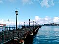
Pier 7, The Embarcadero, looking towards Yerba Buena Island.
-
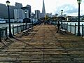
The end of Pier 7, looking towards The Embarcadero and the Transamerica Pyramid.
-
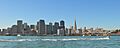
View from the bay in 2007.
-
View of Yerba Buena Island and the Bay Bridge.


See also
 In Spanish: El Embarcadero (San Francisco) para niños
