
Treasure Island, San Francisco facts for kids
Quick facts for kids
Treasure Island
Magic Isle
|
|
|---|---|
|
Landform and neighborhood
|
|
.jpg)
The western side of Treasure Island as seen from Yerba Buena Island. Faintly visible in the distance are the Richmond–San Rafael Bridge and Brickyard Cove.
|
|
.svg)
Treasure Island is the northernmost area of San Francisco's District 6
|
|

Treasure Island
Location in San Francisco
|
|
| Country | |
| State | |
| City-county | San Francisco |
| Constructed | 1936–37 |
| Named for | Treasure Island (novel) |
| Area | |
| • Total | 0.9 sq mi (2 km2) |
| • Land | 0.9 sq mi (2 km2) |
| • Water | 0 sq mi (0 km2) 0% |
| Population
(2024 estimate)
|
|
| • Total | 2,800 |
| • Density | 3,110/sq mi (1,200/km2) |
| Time zone | UTC-8 (Pacific) |
| • Summer (DST) | UTC-7 (PDT) |
| ZIP Code |
94130
|
| Area codes | 415/628 |
| GNIS feature IDs | 236528 (island) 2624152 (Building 157) 2506912 (Job Corps Ctr) |
| Wikimedia Commons | Treasure Island, California |
| Reference #: | 987 |
Treasure Island is a special island in San Francisco Bay, California. It's not natural; people built it! This island is also a neighborhood within the City and County of San Francisco.
It was created between 1936 and 1937 for a big event called the Golden Gate International Exposition in 1939. The island got its name from the famous book Treasure Island. Today, the place where the World's Fair happened is a California Historical Landmark. Many of its historic buildings are listed on the National Register of Historic Places. Treasure Island is connected to Yerba Buena Island, a natural island, by a road called a causeway. This causeway helps people get to Interstate 80.
Contents
Exploring Treasure Island's Location

Treasure Island is located in San Francisco Bay. It's about 393 acres big. It's linked to Yerba Buena Island by a causeway that is about 900 feet long. Yerba Buena Island then connects to Interstate 80, which runs across the San Francisco–Oakland Bay Bridge.
Together, Treasure Island and Yerba Buena Island cover about 576.7 acres. In 2010, about 2,500 people lived on both islands. The island has a marina for boats and a path for bikes. This path connects to the newer part of the Eastern span replacement of the San Francisco–Oakland Bay Bridge.
The Story of Treasure Island
Before Treasure Island was built, there were dangerous rocks called "Yerba Buena Shoals" in the bay. These rocks were a problem for ships. To create the island, workers first built strong rock walls around the area. They used 287,000 tons of rock for these walls.
Then, they filled the inside with about 23 feet of sand from the bay. After making the soil good for plants, they added 50,000 cubic yards of topsoil. They planted 4,000 trees, 70,000 shrubs, and 700,000 flowering plants to make the island beautiful.
The Golden Gate International Exposition
On February 18, 1939, Treasure Island opened as the "Magic City" for the Golden Gate International Exposition. It had many special areas, like a central Court of Honor and a Port of Trade Winds. There was also a huge parking lot for 12,000 cars.
Important buildings included the Federal Building and the Administration Building. Two large hangars were built for Pan Am Airways' flying boats, like the famous China Clipper. These planes would use the Port of Trade Winds Harbor, now called Clipper Cove. Some of these original buildings, like Building 1 (the Pan Am terminal) and the hangars, are still there today.
Treasure Island was so famous that it was even mentioned in a song from the 1939 Marx Brothers film, At The Circus. It also appeared in a travel film called "Night Descends on Treasure Island" in 1940.
Treasure Island as a Military Base

Treasure Island was first planned to be a second airport for San Francisco. However, as World War II approached, the United States Navy took over the island.
The Naval Station Treasure Island started as a Navy "reception center" in 1941. On April 17, 1942, the U.S. Navy officially took control of the island. The Navy later paid San Francisco $10 million to improve the city's existing airport.
During World War II, many thousands of soldiers passed through Treasure Island. They were prepared for assignments in the Pacific or processed to return home after the war. The island also had a Naval Auxiliary Air Facility. This facility supported different types of aircraft, including helicopters, planes, and seaplanes.
From before the 1950s through the 1990s, the Navy had a training center here. Sailors learned important skills like electronics, radiation detection, and how to control damage on ships.
The naval station closed in 1997. Some military buildings remain, like Building 600, which is now a training facility for the San Francisco Fire Department. Building 180 is now a winery.
SAC Radar Station
Treasure Island also hosted a special radar station for the Strategic Air Command (SAC). This station, called the San Francisco Bomb Plot, helped train bomber crews during the Cold War. It evaluated practice bombing missions over the San Francisco metropolitan area. The radar unit moved off the island by 1954.

Treasure Island in Movies and TV
Since the late 1980s, the old aircraft hangars on Treasure Island have been used as film studios. Many famous movies and TV shows were filmed here. For example, parts of The Matrix (including the "bullet time" effect), Rent, and The Pursuit of Happyness were shot on the island.
Other movies filmed here include Charlie Chan at Treasure Island (1939), Indiana Jones and the Last Crusade (1989), Flubber (1997), and The Parent Trap (1998). The TV show Nash Bridges also had its sets on the island. For a few seasons, Battlebots was filmed here. The popular science show MythBusters often used the island for their experiments.
Cleaning Up and Building New Things
After the Navy left, there was a big effort to clean up the island. In 2007, crews cleaned the coast after an oil spill. In 2009, the Navy agreed to sell the island to the city for $105 million for a new development project.
The federal government still uses about 40 acres for a United States Department of Labor Job Corps center. This center helps young people learn job skills.
In 2011, the San Francisco Board of Supervisors approved a plan to build a new neighborhood on the island. This project, called the Treasure Island Development, will create up to 8,000 new homes, shops, offices, and three hotels. It also includes 300 acres of new parks. The island's ferry terminal started construction in 2019.
Because the island was a former military base, some areas needed special cleanup. By December 2010, workers had removed 16,000 cubic yards of contaminated dirt. In 2013, higher levels of a substance called caesium-137 were found. This was because the island had been a training center for nuclear warfare and hosted ships from atomic tests.
Parks and Green Spaces
The plan for Treasure Island and nearby Yerba Buena Island includes creating about 290 acres of open space and parks. This will give residents and visitors many places to enjoy nature and outdoor activities.
Education on Treasure Island
.jpg)
Treasure Island is part of the San Francisco Unified School District (SFUSD). While there used to be a Treasure Island K-8 School, it closed in 2005. Now, elementary students from the island attend schools like John Yehall Chin and Sherman in other San Francisco neighborhoods.
There is also a charter school on the island called Life Learning Academy.
Images for kids
-
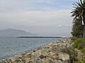
Looking north towards the Marin Headlands from the western shore.
-
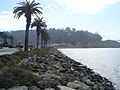
Looking south towards Yerba Buena Island and the Bay Bridge from the western shore.
-
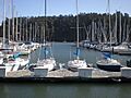
Treasure Island Marina on the island's south shore
-
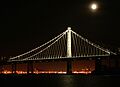
The bridge's new eastern span is best viewed from near the marina
-
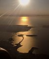
The San Francisco–Oakland Bay Bridge, Yerba Buena Island, Treasure Island, and San Francisco, in an afternoon aerial view looking into the sun


See also
 In Spanish: Isla Treasure para niños
