
Marin Headlands facts for kids


The Marin Headlands is a hilly piece of land that sticks out into the ocean. It's located at the very south end of Marin County, California, in the United States. It's just north of San Francisco and connected by the famous Golden Gate Bridge. This whole area is part of the Golden Gate National Recreation Area. The Headlands are well-known for their amazing views of the San Francisco Bay Area, especially the Golden Gate Bridge itself.
Contents
Weather in the Marin Headlands
The Marin Headlands often make their own clouds! This happens when warm, moist air from the Pacific Ocean moves up into colder air. This causes condensation, which means the water vapor turns into tiny droplets. These droplets form fog, and sometimes even rain. The hills also get more rain than areas closer to sea level for the same reason.
Even though it's quite wet, strong, windy breezes from the Pacific Ocean stop thick forests from growing here. The many gaps and valleys in the hills make the wind even faster. During strong winter storms, these winds can become as powerful as a hurricane. In summer, the ocean air and fog still bring strong, gusty winds across the hills.
From November to February, the Headlands usually have many rainstorms that come from the Pacific. These storms often start near the Gulf of Alaska. They bring most of the area's yearly rainfall. These cloudy, gray, and rainy days are often followed by cool but very clear days.
As winter turns to spring, from April to June, the weather is usually very windy. There's less rain, and the skies are clearer. Summer days can be clear and warm, but they often change to foggy and cool periods. September and October are usually the warmest months of the year. They also have the longest periods of clear skies.
Hawk Hill: A Bird Watcher's Paradise
The most important spot in the Marin Headlands is Hawk Hill. It's about 920 feet (280 meters) high. This hill is the best place to watch the largest known group of raptors flying in the Pacific states.
Every autumn, from August to December, tens of thousands of birds of prey fly through this area. These birds include hawks, kites, falcons, eagles, vultures, osprey, and harriers. They are guided into the Headlands by the shape of Marin County, which is like a funnel. Hawks try to avoid flying over water because warm air currents, which help them fly, are rare there.
The park has many small mammals, which are a good food source for the raptors visiting in the fall. Also, the strong winds from the ocean hitting the Headlands' hills create cold air currents that go upwards. Warm air currents on hot late summer days also help these birds fly more easily.
Volunteers from the Golden Gate Raptor Observatory count and track this fall migration. They use methods like bird-banding and radio-tracking. They do all this work with the help of the National Park Service.
Wildlife in the Marin Headlands
The Marin Headlands is home to many animals. You might see black-tailed deer, mountain lions, bobcats, two types of fox, coyotes, wild turkeys, hares, rabbits, raccoons, and skunks.
In 2003, someone reported seeing a black bear in the Headlands. This report seemed more believable when bear droppings were found on a hiking trail in 2012. Another bear was seen in 2011 at the Point Reyes National Seashore. River otters live in the freshwater lagoons and streams.
Many water birds also travel through the Headlands. These include brown pelicans from May to October. You can also see grebes, egrets, and great blue herons in the spring, summer, and fall. Because the Headlands are a park, the homes and populations of these animals are protected. This is amazing, as they live just a few miles from San Francisco and its busy suburbs.
In the waters around the Headlands, you can find harbor seals all year. Gray whales can be seen in the spring and fall. Seabirds like common murres and surf scoters swim close to the shore.
When Richard Henry Dana Jr. visited San Francisco Bay in 1835, he wrote about huge herds of elk on the Marin Headlands. He described seeing "hundreds and hundreds of red deer [elk], and the stag, with his high branching antlers, were bounding about..."
Geology: How the Headlands Were Formed

The Marin Headlands are made of amazing rock formations. These rocks were created when ocean sediments from the Pacific Plate slowly joined onto the North American Plate. This process, where the ocean floor slides under another plate and then attaches to it, was first explained here in 1984.
The main types of rocks in the Marin Headlands are graywacke sandstone, radiolarian chert, serpentinite, pillow basalts, and shale. These rocks started their journey over one hundred million years ago, coming from as far south as where Los Angeles is today.
Over time, the hillsides have worn away, and building work during the military era has shown off some dramatic examples of these rocks. You can clearly see how the rocks have folded due to the movement of the Earth's plates in many places across the Headlands.

Cultural History of the Headlands
Native American History
The Marin Headlands is the traditional home of the Coastal Miwok tribe. For thousands of years, before European settlers arrived, the Miwok people moved freely between the bay side and the ocean side of the peninsula, depending on the season. The growth of the San Francisco Bay area has sadly affected Miwok sacred places, their culture, and how visible their tribe is today. The Miwok people continue to seek official recognition from the government.
Ranches and Farms
In the 1700s, Spanish and Mexican ranchers lived in the Headlands. Later, after the U.S. took over California, Portuguese immigrant dairy farmers, often from the Azores islands, moved in.
Military History and Fortifications
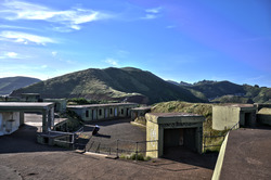
The Marin Headlands has many old military sites and forts. These include Fort Cronkhite, Fort Barry, many bunkers and batteries, and the SF-88 Nike Missile silo.
Starting in the 1890s, the first military buildings were put up to stop enemy ships from entering San Francisco Bay. The batteries at Kirby Cove, above Black Sands Beach, and at Battery Mendell are examples of forts from before World War I.
During World War II, Batteries Wallace, Townsley, and 129 on Hawk Hill were built into the hills. This was to protect them from bombs dropped from planes and from large shells fired by enemy battleships. The spots at the top of Hawk Hill were used for a radio station.
During the Cold War, the gun batteries were no longer used. Instead, anti-aircraft missile sites were built on both sides of Rodeo Lagoon. Radar sites were placed on top of Hawk Hill and Hill 88. In several places, shelters were built into the hillsides to protect military staff from nuclear, biological, or chemical weapons.
Observation posts, called base end stations, can also be found in the Headlands. A good example can be seen near the north end of Rodeo Beach. Others are located near the Point Bonita Lighthouse and on Wolf Ridge.
All military sites in the Headlands are now closed and used by civilians. Some military places, like SF-88, have been kept as historical sites. Many old buildings are now used by non-profit groups. They are kept in their original historical condition.
Another important historical landmark in the Headlands is the Point Bonita Lighthouse.
Stopping a New City
In the 1960s, the government sold over 2,000 acres (8 square kilometers) of land in the Marin Headlands to a private company. This company planned to build a city called Marincello. This new city would have housed 30,000 people in 50 apartment towers, many single-family homes, and a hotel right along the beautiful shoreline and hills.
In 1970, the company lost a lawsuit. The court said the land was illegally zoned for such a big development. The thousands of acres that would have been built on were then sold to the Golden Gate National Recreation Area. This allowed the open space to stay as a park.
Fun Things to Do in the Headlands
Amazing Views
The area offers incredible views of San Francisco. Because of this, it's a very popular place for tourists. One of the most common photos of San Francisco is the view from the Headlands. It shows the city with the towers of the Golden Gate Bridge just peeking out of the fog.
On clear days, you can see across the bay. This includes the Farallon Islands, Angel Island, Alcatraz, the San Francisco–Oakland Bay Bridge, the Golden Gate Bridge, and the East Bay.


Where Conzelman Road runs along the south shore of the Headlands, it becomes a one-way road. A walking path goes up to Hawk Hill from there. A short distance further, on the right, in a group of Monterey pine trees, there's a bench. From this bench, you can see the Golden Gate, ships passing under the bridge, and the city just beyond.
Beaches to Explore


The Headlands has several beaches. These include Rodeo Beach (a dark sand beach covered with pebbles), Kirby Cove, Pirates' Cove, Black Sands Beach, Tennessee Beach, and Muir Beach. You can drive to Rodeo and Muir Beaches. The others require hikes that vary in length and difficulty.
Hiking and Biking Trails
There are many trails for hiking and biking in the Headlands. Several of these trails go through areas with coastal sage scrub, chaparral (a type of shrubland), and areas along rivers.
Bird Watching
The migration of raptors brings many birdwatchers to Hawk Hill. You can also sometimes see waterfowl and seabirds on Rodeo Lagoon.
Places to Visit and Facilities
The National Park Service has a visitor center. It's near the intersection of Field Road and Bunker Road, about a mile from Rodeo Beach. The visitor center has displays about the history and nature of the area. It also has a small bookstore and gift shop. You can get hiking maps and information about Park Service programs there.
There's also Presidio Fire Department Fire Station No. 2, located at building 1045 Fort Cronkhite. This fire station is run by the National Park Service. It has one fire engine that can also help with cliff rescues.
Public restrooms are available in the Headlands at the visitor center parking lot and the parking lot near Rodeo Beach. Portable toilets are also available at the start of the trail to the Point Bonita Lighthouse, along Conzelman Road near Black Sands Beach, at Battery Alexander, and at Battery 129 on Hawk Hill.
Conference centers are located in old military buildings. These are managed by the Point Bonita YMCA, NatureBridge, and the Headlands Center for the Arts. The Cavallo Point conference center is in East Fort Baker, on the eastern side of the peninsula.
Other areas within Marin Headlands include Kirby Cove, Rodeo Lagoon, and Tennessee Cove.
Various non-profit organizations also have facilities in Marin Headlands. These include The Marine Mammal Center, the Foundation for Deep Ecology, and the NatureBridge campus (which used to be called the Headlands Institute). All of these are in Fort Cronkhite. The Headlands Center for the Arts and the Marin Headlands Hostel are at Fort Barry. There are also the Marin Headlands and Tennessee Valley Native Plant Nurseries.
See also
 In Spanish: Marin Headlands para niños
