
Point Reyes National Seashore facts for kids
Quick facts for kids Point Reyes National Seashore |
|
|---|---|
|
IUCN Category V (Protected Landscape/Seascape)
|
|

Headlands of the Point Reyes Peninsula from Chimney Rock, looking north
|
|

Point Reyes National Seashore
Location in California

Point Reyes National Seashore
Location in the United States
|
|
| Location | Marin County, California, United States |
| Nearest city | Point Reyes Station, California |
| Area | 71,028 acres (287.44 km2) |
| Established | September 13, 1962 |
| Visitors | 2,336,202 (in 2022) |
| Governing body | National Park Service |
| Website | Point Reyes National Seashore |
Point Reyes National Seashore is a huge park in Marin County, California. It covers about 71,028-acre (287.44 km2) of land. The National Park Service takes care of this special place. They protect its nature and wildlife.
The park was created in 1962. A US Congressman named Clem Miller helped make it happen. He wanted to save the area from being built on. Some farms and ranches are still allowed to operate inside the park.
Contents
Exploring Point Reyes: Its Land and Location

The Point Reyes Peninsula is a unique place. It's almost completely separated from the rest of California. This is because of the San Andreas Fault, a huge crack in the Earth's crust. Part of this fault is under the water, forming Tomales Bay. The rocks and soil on each side of the fault are different. This means different plants grow on each side.
Small towns near the park help visitors. Point Reyes Station offers many services. Inverness is also nearby. Olema is the main entrance to the Seashore. It has a visitor center where you can learn more.
The park has many different landscapes. You can find wild beaches, rocky cliffs, and calm bays. There are also farms and ranches. These farms have been here for a long time. The National Park Service helps manage visitors. They also work with other groups to protect the whole area.
Amazing Animals and Plants of Point Reyes
Point Reyes National Seashore is a hotspot for nature. It's where two ocean areas meet. This means it has a huge variety of life. About 45% of all North American bird species live here. Also, 18% of California's plant species are found in the park. The park's 100 miles (160 km) of coastline includes bays and lagoons. These areas are perfect homes for many animals and plants.
Wildlife: From Elk to Elephant Seals

The northern part of the peninsula is a special home for tule elk. These elk are a type of deer that used to live all over this area. They disappeared from Point Reyes a long time ago. But in 1978, ten elk were brought back. By 2009, there were over 440 elk at Tomales Point.
Sometimes, droughts make it hard for the elk to find water. In 2012–2015, many elk died because of dry conditions. There's a fence that keeps some elk in one area. People are now discussing whether to remove this fence. This would allow the elk to roam more freely.
The park is also a great place to see birds. You can spot many raptors, like hawks and eagles. There are also many shorebirds. The western snowy plover is a small bird that nests here. It is considered a "threatened" species.
The Point Reyes Lighthouse is a popular spot for whale watching. You can see gray whales migrating past the coast. They travel south in January and north in March.

Elephant seals started coming back to Point Reyes in 1981. They like the protected cliffs of Chimney Beach. In 2019, many seal pups were born on Drakes Beach. Park staff and volunteers help keep people safe while they watch these amazing animals. The seal colony keeps growing each year.
Plant Life: Forests and Coastal Wonders
Point Reyes is part of a special plant area called the California interior chaparral and woodlands.
One important plant community is the Coastal Douglas-fir forest. These trees can be over 300 years old. They grow with other trees like Coast live oak and California bay. Long ago, the Coast Miwok people lived here. They used to set fires to clear the land. This kept the hills mostly grassy. But after Europeans arrived, fewer fires were set. This allowed the forests to grow larger, creating the beautiful woods we see today.
You can also find Bishop pine forests. Many of these trees grew after a big fire in 1995. Salt, brackish, and freshwater marshes are found near Drakes Estero and Abbotts Lagoon. These wet areas are home to many unique plants.
Along the coast, you'll see plants like European beach grass and ice plant. These plants can handle the salty air and sandy soil. Just inland from the coast are grasslands. The park also has areas where cattle still graze. Other areas are covered in northern coastal scrub, with plants like coyote bush.
Point Reyes is the only place in the world where the endangered Sonoma spineflower grows.
Cattle Ranches and the Environment
About 28,000 acres (11,000 ha) of the park are used for dairy and beef cattle ranching. These ranches have been here for a long time. However, there have been concerns about the environment. Sometimes, high levels of bacteria from cattle waste have been found in streams. This can affect the water quality in places like Tomales Bay and Drakes Estero. Park officials are working to address these issues.
Point Reyes Weather: Foggy and Mild

Point Reyes has a mild climate. It's often cool and foggy, especially in the summer. The fog helps keep the area green. Winters are wet, with most of the rain falling between November and March. Summers are usually dry and cool.
|
||||||||||||||||||||||||||||||||||||||||||||||||||||||||||||||||||||||||||||||||||||||||||||||||
Cool Places and Things to Do at Point Reyes

The Point Reyes Lifeboat Station is a very old building. It's a National Historic Landmark. It's the last place like it on the Pacific coast. Lifeboats used to be launched from rails here to rescue people at sea.
Nova Albion is a historic site. It's where explorer Francis Drake might have camped in 1579. There are also Native American sites nearby.
Kule Loklo is a re-created village. It shows what a Coast Miwok village might have looked like. You can walk to it from the visitor center.
Lairds Landing was once a busy wharf on Tomales Bay. A family with Filipino and Miwok heritage lived there. Their old buildings are now on the National Register of Historic Places.
A large part of the park, over 30,000 acres (120 km2), is called the Phillip Burton Wilderness. This area is kept wild and untouched. It's named after a Congressman who helped protect many natural areas.
Point Reyes National Seashore gets about 2.5 million visitors every year. There's even a youth hostel where you can stay. The Point Reyes National Seashore Association helps take care of the park. They also run educational programs.
Hiking Adventures and Trails

Point Reyes has many great hiking trails. The Bear Valley Trail is one of the most popular. It follows a stream through a shady canyon. It ends at the coast near Arch Rock. Sadly, part of Arch Rock collapsed in 2015.

From Bear Valley, you can hike up to Mount Wittenberg. At 1,407 feet (429 m), it's the highest point in the park. The Earthquake Trail is a short, 0.6-mile (0.97 km) loop. It runs right over the San Andreas Fault. You can see a fence that was pulled 18 feet (5.5 m) apart during the huge 1906 San Francisco earthquake.
At the very end of the Point Reyes Peninsula is the historic Point Reyes Lighthouse. You have to walk down 308 steps to reach it! This lighthouse was built low to the ground. This was so its light could shine *under* the thick fog that often covers the area. Nearby, the Chimney Rock hike is famous for its beautiful wildflowers in spring.
There are also several beach walks. Limantour Spit is a narrow sandy beach. North Beach and South Beach are often windy with big waves. For amazing ocean views from higher up, try the Tomales Point Trail. All of the park's beaches were named the cleanest in California in 2010.
If you like backpacking, Point Reyes has four campgrounds you can hike to. You need a reservation to stay there.
Point Reyes is also the end point of the American Discovery Trail. This is a very long trail that crosses the entire United States.
Protecting Ocean Life: Marine Protected Areas
Around Point Reyes National Seashore, there are special ocean areas. These are called marine protected areas. They include Point Reyes State Marine Reserve & Point Reyes State Marine Conservation Area, Estero de Limantour State Marine Reserve & Drakes Estero State Marine Conservation Area, and Duxbury Reef State Marine Conservation Area. These areas help protect ocean wildlife and their homes.
The Oyster Farm Story

There used to be a large oyster farm in Drakes Estero. The National Park Service bought the land in 1972. They allowed the farm to keep operating for 40 years. When the farm was sold in 2004, the new owners were told the permit would not be renewed after 2012.
The park and many conservation groups felt the farm didn't fit with the idea of a "wilderness area." The farm's supporters said it was good for the local economy. In 2012, the Interior Secretary decided not to renew the permit. This meant the oyster farm had to close.
There were many legal challenges to this decision. But in the end, the courts agreed with the Secretary. The oyster farm closed its main operations in 2014. The work to remove the farm's structures was finished in 2017. Now, Drakes Estero is part of the Phillip Burton Wilderness.
Images for kids
-
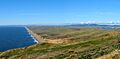
Point Reyes Beach from the Lighthouse Visitor Center
-
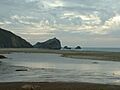
McClure's Beach
-
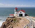
Point Reyes Lighthouse
-
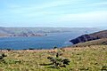
Tule elk on Tomales Point Trail
-
Tomales Bay on the Eastern side
-
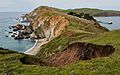
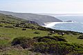
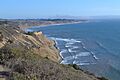
Coastline as seen from Chimney Rock
-
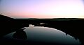
Point Reyes Marsh at dusk
-
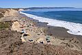
Drakes Beach during the 2015 Annual Sand Sculpture Contest.
-
Wildcat Beach
-
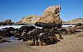
McClures Beach


.jpg)


