Inverness, California facts for kids
Quick facts for kids
Inverness
|
|
|---|---|

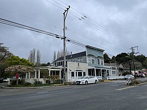
Inverness in 2022
|
|

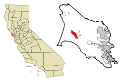
Location in Marin County and the state of California
|
|
| Country | |
| State | |
| County | Marin |
| Area | |
| • Total | 6.836 sq mi (17.71 km2) |
| • Land | 6.400 sq mi (16.58 km2) |
| • Water | 0.436 sq mi (1.13 km2) 6.38% |
| Elevation | 43 ft (13 m) |
| Population
(2020)
|
|
| • Total | 1,379 |
| • Density | 215.5/sq mi (83.2/km2) |
| Time zone | UTC-8 (PST) |
| • Summer (DST) | UTC-7 (PDT) |
| ZIP code |
94937
|
| Area codes | 415/628 |
| FIPS code | 06-36616 |
| GNIS feature ID | 1658827 |
Inverness is a small community in Marin County, California, United States. It's located on the southwest shore of Tomales Bay. This area is about 3.5 miles (5.6 km) northwest of Point Reyes Station. It's also about 40 miles (64 km) northwest of San Francisco by road.
Inverness sits at an elevation of 43 feet (13 meters) above sea level. In 2020, about 1,379 people lived there. A Scottish landowner gave the community its name, inspired by Inverness in Scotland.
Contents
Life in Inverness
Inverness is on the west side of Tomales Bay. This bay follows the line of the San Andreas Fault. The community is surrounded by the beautiful Point Reyes National Seashore. It's mostly a place where people live, with tourism being its main industry.
The town has a small downtown area. You can find a general store, a post office, and a library there. There are also a couple of restaurants, a gift shop, and a coffee shop. More hotels and inns are spread throughout the town for visitors.
Boating is a big part of life in Inverness. There's a public marina and some private piers. The Inverness Yacht Club is also located here.
Inverness has been a filming location for movies. Parts of the film The Fog and most of Village of the Damned were filmed here. Famous singer-songwriter Jesse Colin Young moved to Inverness in 1970. He even set up his recording studio in his home. In 1993, he and his wife started their music label, Ridgetop Music, from Inverness.
Inverness History
Inverness is about 5 miles (8 km) northeast of Drakes Bay on the Pacific Ocean. Drakes Bay is named after Sir Francis Drake. He explored this coast in the 1500s. His ship's doctor wrote about landing in a place that looked like the White Cliffs of Dover. Drakes Bay has similar cliffs, so many believe Drake landed there.
The land became owned by James McMillan Shafter in the 1890s. He started to develop the area. Inverness became a popular summer resort. People from San Francisco and Oakland came to camp, hike, and swim. Many built small summer cabins that are still there today.
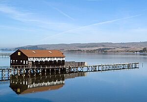
Small steamboats would take people on day trips down the bay. They would visit secluded beaches. These boats left from Brock Schreiber's boathouse. This boathouse is still a local landmark with its "Launch for Hire" sign. The first post office in Inverness opened in 1897.
In 1995, the Mt. Vision Fire happened on Inverness Ridge. This fire burned a large part of Point Reyes National Seashore. It also destroyed some homes on the ridge. Helicopters used water from Tomales Bay to save the town. They dropped water on the forest between the town and the fire.
Geography of Inverness
Inverness is located at 38°06′04″N 122°51′25″W / 38.10111°N 122.85694°W. The area covers about 6.8 square miles (17.6 sq km). Most of this area, 6.4 square miles (16.6 sq km), is land. About 0.4 square miles (1.0 sq km), or 6.38%, is water.
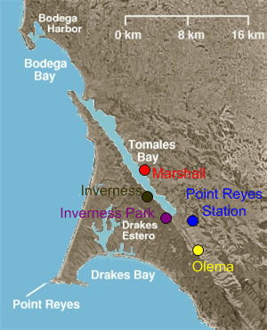
The community also includes Inverness Park. This smaller community is southeast of Inverness. Point Reyes Station borders Inverness to the east.
The town is very close to the San Andreas Fault. It stretches for about 2 miles (3.2 km) along the western shore of Tomales Bay. Inverness is on the Point Reyes Peninsula. It provides services for visitors to the Point Reyes National Seashore and Tomales Bay State Park.
Inverness Climate
Inverness has a Mediterranean climate. This means it has cool, rainy winters and mild, dry summers. The nearby Pacific Ocean greatly influences its weather. Temperatures don't change much throughout the year. September is usually the warmest month. This is common in the Bay Area due to ocean currents.
| Climate data for Inverness (1981-2010 normals) | |||||||||||||
|---|---|---|---|---|---|---|---|---|---|---|---|---|---|
| Month | Jan | Feb | Mar | Apr | May | Jun | Jul | Aug | Sep | Oct | Nov | Dec | Year |
| Mean daily maximum °F (°C) | 55.2 (12.9) |
58.4 (14.7) |
60.1 (15.6) |
61.8 (16.6) |
63.6 (17.6) |
65.4 (18.6) |
67.6 (19.8) |
67.9 (19.9) |
69.1 (20.6) |
67.2 (19.6) |
62.1 (16.7) |
55.7 (13.2) |
62.8 (17.1) |
| Daily mean °F (°C) | 48.1 (8.9) |
50.5 (10.3) |
52.0 (11.1) |
53.4 (11.9) |
55.9 (13.3) |
58.2 (14.6) |
60.0 (15.6) |
60.3 (15.7) |
60.5 (15.8) |
57.8 (14.3) |
53.4 (11.9) |
48.1 (8.9) |
54.8 (12.7) |
| Mean daily minimum °F (°C) | 41.1 (5.1) |
42.7 (5.9) |
43.8 (6.6) |
45.0 (7.2) |
48.2 (9.0) |
50.9 (10.5) |
52.3 (11.3) |
52.8 (11.6) |
51.8 (11.0) |
48.5 (9.2) |
44.6 (7.0) |
40.5 (4.7) |
46.9 (8.3) |
| Average precipitation inches (mm) | 6.62 (168) |
6.54 (166) |
4.67 (119) |
2.17 (55) |
1.35 (34) |
0.24 (6.1) |
0.02 (0.51) |
0.10 (2.5) |
0.31 (7.9) |
1.72 (44) |
4.09 (104) |
6.44 (164) |
34.27 (870) |
| Source: PRISM Climate Group | |||||||||||||
People of Inverness
In 2010, the population of Inverness was 1,304 people. Most residents, about 92.9%, were White. About 1.2% were African American, and 0.6% were Native American. Around 1.2% were Asian. About 6.1% of the population was Hispanic or Latino.
There were 697 households in Inverness. About 12.9% of these households had children under 18. Many households, 43%, were married couples. The average household had 1.87 people. The average family size was 2.46 people.
The median age in Inverness was 57.3 years old. This means half the people were older than 57.3 and half were younger. About 10.7% of the people were under 18. About 26.9% were 65 or older.
Most homes, 64.7%, were owned by the people living in them. The rest, 35.3%, were rented.
See also
 In Spanish: Inverness (California) para niños
 | Valerie Thomas |
 | Frederick McKinley Jones |
 | George Edward Alcorn Jr. |
 | Thomas Mensah |


