
National Register of Historic Places listings in Marin County, California facts for kids

Marin County, California, is a beautiful area known for its stunning natural landscapes and rich history. Many places in Marin County are so special that they are listed on the National Register of Historic Places. This is a list kept by the United States government to recognize buildings, sites, and objects that are important in American history, architecture, archaeology, engineering, or culture.
When a place is added to the National Register, it means it's worth preserving for future generations. Marin County has 52 such special places! Four of these are even more important and are called National Historic Landmarks. These landmarks are recognized as having exceptional national historical significance. Let's explore some of these amazing historic sites!
Discovering Marin County's Historic Sites
Angel Island Immigration Station

Located on Angel Island in San Francisco Bay, this station was once the main entry point for immigrants coming to the United States from Asia, especially between 1910 and 1940. It's often called the "Ellis Island of the West." Thousands of people passed through here, hoping to start new lives in America. Today, it's a museum where you can learn about their journeys and experiences. It's a very important place for understanding American immigration history.
Drakes Bay Historic and Archeological District

This area near Point Reyes Station is super old and important! It's believed to be where famous explorers like Sir Francis Drake (in 1579) and Sebastian Rodriguez Cermeño (in 1595) first landed in California. Imagine meeting people from a completely different part of the world for the first time! This district helps us understand the early meetings between Native Americans and European visitors.
Marin County Civic Center

The Marin County Civic Center in San Rafael is a truly unique building. It was designed by the famous architect Frank Lloyd Wright, and it was his very last big project! Completed in 1962, after his death, it's known for its long, curving lines, blue roof, and golden spire. It's a great example of modern architecture and still serves as the county's government center today.
Point Reyes Lifeboat Rescue Station

Located at Drake's Bay within the Point Reyes National Seashore, this station was built in 1927. Its job was to help rescue people from ships in trouble along the coast. The brave crews here would launch their lifeboats into the often-stormy waters to save lives. It's a reminder of the dangers of the sea and the courage of those who worked to keep sailors safe.
Forts Baker, Barry, and Cronkhite
.jpg)
South of Sausalito, you'll find a group of old military forts: Fort Baker, Fort Barry, and Fort Cronkhite. These forts were built to protect San Francisco Bay from attacks, especially during World War II. They have interesting old buildings, gun batteries, and tunnels. Today, they are part of the Golden Gate National Recreation Area and are popular spots for hiking and exploring.
Muir Woods National Monument

Muir Woods National Monument is a magical place filled with towering Coast Redwood trees. These trees are some of the tallest and oldest living things on Earth! The monument is named after John Muir, a famous naturalist who helped protect many natural areas. Walking through Muir Woods feels like stepping into another world, with sunlight filtering through the ancient canopy. It's a wonderful place to connect with nature.
Point Bonita Lighthouse
.JPG)
Perched on a dramatic cliff in the Marin Headlands, the Point Bonita Lighthouse has guided ships into San Francisco Bay since 1887. It's unique because you have to cross a suspension bridge to reach it! This lighthouse was the last one on the California coast to be operated by a human keeper, until it became automated in 1980. It offers incredible views of the Pacific Ocean and the Golden Gate Bridge.
Point Reyes Lighthouse

Another important lighthouse in Marin County is the Point Reyes Lighthouse, located at the very tip of the Point Reyes National Seashore. It was first lit in 1870 and is often shrouded in dense fog, making its light and foghorn crucial for ships. The lighthouse sits at the end of a long walkway and down many steps, offering a unique experience and stunning views of the ocean.
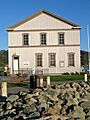
China Camp

China Camp in San Rafael is a historic Chinese fishing village from the 1800s. Chinese immigrants came here to fish for shrimp and other seafood. It's one of the last remaining Chinese fishing villages in California. You can still see some of the original buildings and learn about the lives of the people who lived and worked there. It's now a state park where you can enjoy the bay and learn about this unique history.
The Dipsea Trail

The Dipsea Trail is a famous and challenging hiking trail that stretches from Mill Valley to Stinson Beach. It's known for its beautiful scenery, steep stairs, and tough climbs. Every year, the Dipsea Race, one of the oldest trail races in the country, is held here. It's a great place for adventurers and nature lovers to explore Marin County's natural beauty.
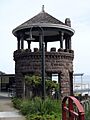
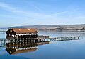
Olema Lime Kilns
.jpg)
Southeast of Olema, you can find the Olema Lime Kilns. These old stone structures were used to heat limestone to make lime, which was an important material for building and agriculture in the 1800s. They are a cool example of early industrial history in the area.
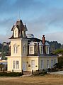
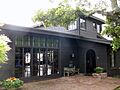
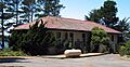
Outdoor Art Club

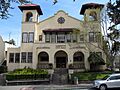
The Outdoor Art Club in Mill Valley is a beautiful clubhouse built in 1904. It was designed by a famous architect named Bernard Maybeck. The club was started by women who wanted to protect the natural beauty of Mill Valley and promote art and culture. It's a lovely example of the "American Craftsman style" of architecture, surrounded by pretty gardens.
Rancho Olompali

Located in Novato, Rancho Olompali is a site with a very long history. It was once a village for the Coast Miwok Native American people. Later, it became a large Mexican ranch, and then a ranch with different buildings. Today, it's a state historic park where you can learn about the different groups of people who lived there over hundreds of years.
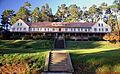
West Point Inn

High up on Mount Tamalpais, you'll find the West Point Inn. This inn was built in 1904 and was a stop along the old Mount Tamalpais and Muir Woods Railway. People would ride the scenic railway up the mountain and stay at the inn to enjoy the views. Today, it's still a popular spot for hikers and cyclists to rest and enjoy the amazing scenery.
Other Notable Historic Places
Marin County is home to many other fascinating historic sites, including:
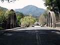
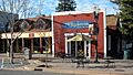
- The Alexander-Acacia Bridge in Larkspur.
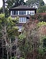
- The William G. Barrett House and Griswold House in Sausalito.
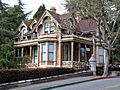
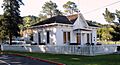
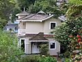
- The Boyd House and Bradford House in San Rafael.
- The Dixie Schoolhouse, an old school building in San Rafael.
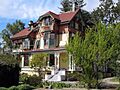
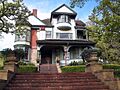
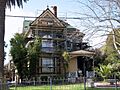
- The Robert Dollar Estate and Robert Dollar House in San Rafael.
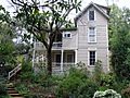
- The Dolliver House in Larkspur.
- The Fashion Shop and Stephen Porcella House in Novato.
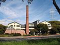
- The Green Brae Brick Yard in Larkspur, which is now a restaurant.
- The Hamilton Army Air Field Discontiguous Historic District in Novato.
- The Larkspur Downtown Historic District, with many historic buildings.
- Lyford's Stone Tower and the Benjamin and Hilarita Lyford House in Tiburon.
- The Marinship Machine Shop in Sausalito.
- The Erskine B. McNear House in San Rafael.
- The Mount Tamalpais Mountain Theater in Mill Valley.
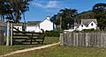
- The Pierce Ranch in Inverness.
- The Valentine Rey House in Belvedere.
- The San Francisco and North Pacific Railroad Station House-Depot in Tiburon.
- The San Rafael Improvement Club.
- The Sausalito Woman's Club, designed by architect Julia Morgan.
- The Brock Schreiber Boathouse and Beach in Inverness.
- Station KPH Operating Station and Station KPH, Marconi Wireless Telegraph Company of America in Marshall.
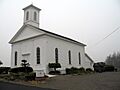
- The Tomales Presbyterian Church and Cemetery.
These places, along with others, help tell the story of Marin County and its important role in California and American history.
Images for kids
-
Alexander-Acacia Bridge
-
William G. Barrett House
-
Boyd House
-
Bradford House
-
Dixie Schoolhouse
-
Robert Dollar Estate
-
Robert Dollar House
-
Dolliver House
-
Fashion Shop and Stephen Porcella House
-
Green Brae Brick Yard
-
Griswold House
-

Hamilton Army Air Field
-
Larkspur Downtown Historic District
-
Lyford's Stone Tower
-
Benjamin and Hilarita Lyford House
-

Marinship Machine Shop
-
Erskine B. McNear House
-
Mount Tamalpais Mountain Theater
-
Pierce Ranch
-
Valentine Rey House
-
San Francisco and North Pacific Railroad Station House-Depot
-

San Rafael Improvement Club
-
Sausalito Woman's Club
-
Brock Schreiber Boathouse and Beach
-
Station KPH Operating Station
-
Station KPH, Marconi Wireless Telegraph Company of America
-
Tomales Presbyterian Church and Cemetery


.JPG)
.JPG)


