
Farallon Islands facts for kids
Quick facts for kids Farallon Islands National Wildlife Refuge |
|
|---|---|
|
IUCN Category Ia (Strict Nature Reserve)
|
|

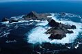
Southeast Farallon Islands from the west, with Maintop Island in the foreground (right)
|
|
 |
|
| Location | Pacific Ocean |
| Nearest city | San Francisco, California, United States |
| Area | 41.9 acres (17.0 ha) |
| Established | 1969 |
| Governing body | United States Fish and Wildlife Service |
| Website | Farallon Islands National Wildlife Refuge |
|
Farallon Islands
|
|
| Area | 211 acres (85.4 ha) |
| NRHP reference No. | 77000332 |
| Added to NRHP | March 8, 1977 |


The Farallon Islands, also called the Farallones, are a group of islands and tall sea stacks. They are located in the Gulf of the Farallones, off the coast of San Francisco, California, United States. Sailors sometimes call them the Devil's Teeth Islands. This is because of the many dangerous underwater shoals nearby. The islands are about 30 miles (48 km) outside the Golden Gate. They are also 20 miles (32 km) south of Point Reyes. On clear days, you can see them from the mainland.
The Farallon Islands are part of the City and County of San Francisco. Only Southeast Farallon Island (SEFI) has people living on it. These are researchers from Point Blue Conservation Science and the U.S. Fish and Wildlife Service. The islands are closed to the public.
The Farallon Islands National Wildlife Refuge is a special protected area. It is one of 63 national wildlife refuges with wilderness status. In 1974, the Farallon Wilderness was created. It includes all islands except Southeast Island, covering 141 acres (57 ha). The waters around the islands are also protected. They are part of the Greater Farallones National Marine Sanctuary.
Contents
History of the Farallon Islands

The peaks of the Farallon Islands can be seen from San Francisco. Native Americans in the area knew about them. They believed the islands were home to the spirits of the dead. It is not thought that they traveled to the islands.
The first Europeans to see these islands were likely from the Juan Cabrillo expedition in 1542. However, no records of their sighting have survived. The first European to write about the islands was Sir Francis Drake. He was an English explorer. On July 24, 1579, Drake landed on the islands. He collected seal meat and bird eggs for his ship. He named them the Islands of Saint James.
The islands were later named "Farallones" by Friar Antonio de la Ascencion. This was during the 1603 expedition of Sebastián Vizcaíno. "Farallones" means "cliffs" in Spanish. For about 200 years after Drake, sailors often avoided the islands. Their scary look, just off the entrance to San Francisco Bay, made them sail far to the west. This is why San Francisco Bay was discovered much later by land.
Early Exploitation and the Egg War
After the islands were discovered, they were used by seal hunters. First, hunters from New England came. Then, hunters from Russia arrived. Russians had a sealing station there from 1812 to 1840. They caught many fur seals. American ships also hunted seals. By 1818, the number of seals dropped very quickly. The fur seal was almost gone from the islands.
In 1848, the islands became part of the United States. A lighthouse was built on Southeast Farallon Island in 1853. As San Francisco grew, seabird colonies were in danger. Millions of eggs were collected for markets in San Francisco. This egg trade caused problems between egg-collecting companies and lighthouse keepers. In 1863, a fight between rival companies, called the Egg War, happened. Two men died. This ended private companies on the islands, but lighthouse keepers continued to collect eggs.
From 1902 to 1913, a weather station was on the southeast island. It was connected to the mainland by cable. Temperatures during those years never went above 90°F (32°C) or below 32°F (0°C).
Nuclear Waste Dumping
From 1946 to 1970, the sea around the Farallones was used to dump radioactive waste. This was done by the United States Atomic Energy Commission. Most of the dumping happened before 1960. All dumping of radioactive waste by the U.S. stopped in 1970. About 47,500 containers were dumped. These containers held mostly lab materials with small amounts of contamination. By 1980, most of the radiation had gone away.
The containers were shipped to Hunters Point Shipyard. Then, they were loaded onto barges and taken to the Farallones. The containers were weighted with concrete. If they floated, they were sometimes shot to make them sink. In 1951, the highly radioactive hull of the USS Independence was sunk here. This ship was used in nuclear weapons tests. Its wreck was found again in 2015.
The exact location of all containers is not known. Experts say that trying to remove the barrels would likely be more dangerous than leaving them alone.
Swimming Achievements
Three people have successfully swum from the Farallones to the Golden Gate. Two others swam to points north of the gate.
- The first was Ted Erikson in September 1967.
- Joseph Locke swam to the Golden Gate on July 12, 2014. It took him 14 hours.
- The first woman to complete the swim was Kimberley Chambers. She did it in just over 17 hours on August 7, 2015.
Protected Area Status
The collecting of eggs and the danger of oil spills led to protection for the islands. In 1909, President Theodore Roosevelt signed an order. It created the Farallon Reservation to protect the northern islands. This protection was expanded in 1969. The islands then became a national wildlife refuge.
In 1981, the Gulf of the Farallones National Marine Sanctuary was created. It covered 1,279 square miles (3,313 km2) of water around the islands. This sanctuary protected the ocean, tidal flats, reefs, and beaches. In 2015, the sanctuary was made much larger. It now covers 3,295 square miles (8,534 km2). Its name was changed to Greater Farallones National Marine Sanctuary.
The islands are managed by the United States Fish and Wildlife Service. They work with Point Blue Conservation Science. The Farallones are currently used for long-term ecological research. The islands are closed to the public. However, people can see them from whale watching boats.
Geology of the Islands
The Farallon Islands are made of rock from the Salinian Block. This is a large area of granitic rock. It has the same origins as the Sierra Nevada Mountains. This rock block moved north a long time ago. The islands sit on the Pacific Plate. Other nearby examples of this rock are the Point Reyes Peninsula and Bodega Head. The San Andreas Fault passes a few miles east of the islands. This fault is where the Pacific and North American Plates meet.
The ancient Farallon Plate is named after these islands.
Geography of the Islands

Island Overview
The islands stretch northwest from Southeast Farallon Island for 5 miles (8 km). Their total land area is about 0.16 square miles (0.41 km2). The islands were first used for bird eggs and fur seal skins. Later, they became a lighthouse station and a radio station. They are now protected in the Farallon Islands National Wildlife Refuge. This refuge was first set up in 1909. The Southeast Farallons were added in 1969. The islands have the largest seabird colony in the U.S. outside of Alaska and Hawaii. The islands are part of the City and County of San Francisco.
| Block Nr. | Island(s) or Bank | Area (m2) |
Height (m) |
Coordinates |
|---|---|---|---|---|
| 2000 | South Farallon Islands | 387,688 | 109 | 37°41′49″N 123°00′07″W / 37.69694°N 123.00194°W |
| 2001 | Middle Farallon Island | 3,362 | 6 | 37°43′37″N 123°01′52″W / 37.72694°N 123.03111°W |
| 2002 | North Farallon Islands | 28,270 | 47 | 37°45′37″N 123°05′49″W / 37.76028°N 123.09694°W |
| – | Fanny Shoal | – | −4 | 37°46′40″N 123°10′19″W / 37.77778°N 123.17194°W |
| 2999 | Farallon Islands | 419,320 | 109 |
South Farallon Islands


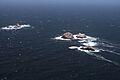
- Southeast Farallon Island (SEFI) is the largest island. It covers about 95.79 acres (0.3876 km2). It is the only island where people live. The island is shaped like a pyramid and is 357 feet (109 m) high. The highest point, Tower Hill, has a lighthouse called the Farallon Island Light.
- Seal Rock (Saddle Rock) is about 800 feet (240 m) south of SEFI. It is about 80 feet (24 m) high.
- Maintop Island (West End) is right next to SEFI. A narrow channel called The Jordan separates them.
- The Drunk Uncle Islets are small rocks northwest of Maintop Island.
- Aulon Island and Great Arch Rock are north of SEFI. Sugarloaf Island is northeast of Great Arch Rock.
- Hurst Shoal is about one kilometer southeast of SEFI. It is a shallow area.
Middle Farallon Island
Middle Farallon Island is 2 miles (3.2 km) northwest of SEFI. It is a 20-foot (6.1 m) high black rock covered in guano (bird droppings). It is about 65 meters wide. People sometimes call this island "the pimple."
North Farallon Islands

The North Farallon Islands are about 7 km (4.3 mi) further northwest. They are two groups of bare, steep islets and rocks. They are 31 to 85 meters high.
- North Farallon Island is 31 meters high.
- Island of St. James is 47 meters high.
- There are also several smaller, unnamed rocks. Some of these have Spanish names.
Fanny Shoal
Fanny Shoal is 5 km (3.1 mi) west-northwest of the North Farallones. It is a bank about 3 km (1.9 mi) wide. It is entirely underwater. Noonday Rock is the shallowest part of Fanny Shoal. It is only 4 meters (13 ft) deep at low tide. This rock is named after a clipper ship that hit it and sank in 1863.
Climate of the Islands
The Farallon Islands have a very mild mediterranean climate. This is because they are offshore in the cold California Current. The cold water makes it quite chilly most of the year. Even when nearby San Francisco is very hot, the islands stay cool. Temperatures rarely go above 60°F (16°C) in summer. Winters are mild, but often cooler than San Francisco. It is very rare for temperatures to drop below 50°F (10°C) in winter. The islands can also have strong offshore winds in winter.
Flora and Fauna of the Farallones

Seabirds of the Farallones
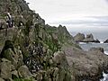
The Farallon Islands are a very important place for seabirds. Over 250,000 seabirds live here. This is because of the rich waters of the California Current. Also, there are no other large islands nearby for nesting. Twelve species of seabirds and shorebirds nest on the islands. These include:
- western gull
- Brandt's cormorant
- pelagic cormorant
- double-crested cormorant
- pigeon guillemot
- common murre
- Cassin's auklet
- tufted puffin
- black oystercatcher
- rhinoceros auklet
- ashy storm-petrel
- Leach's storm-petrel
Since the islands became protected, common murre numbers have grown a lot. They went from 6,000 birds to 160,000. The rhinoceros auklet, which had disappeared from the islands, has started breeding there again. The islands have the world's largest groups of western gulls and ashy storm petrels. The ashy storm petrel is an endangered bird. Many other types of birds also visit the island during migration.
Seals of the Farallones

Five types of pinnipeds (seals and sea lions) come to the islands. Some of them also breed there. These are:
Hunters took many northern fur seals from the Farallones between 1810 and 1813. By 1996, northern fur seals started to return to the islands. By 2016, over 1,100 pups were born there. The fur seals are quite strong. They have taken over areas from larger sea lions. If the northern fur seal population grows to its old size, it could be a big part of the world's population.
Northern elephant seals also returned to the refuge in 1959. A pup was confirmed in 1972. The elephant seal breeding area on Southeast Farallon is now likely full.
Whales Near the Islands
Several types of cetaceans (whales and dolphins) are found near the Farallon Islands. The most common are gray whales, blue whales, and humpback whales. Blue and humpback whales are often seen in summer and fall. This is when there is a lot of food in the ocean. Orca whales are also found around the islands. Gray whales are seen during their spring and fall migrations. Some gray whales even stay near the Farallones in the summer.
The islands are in the Gulf of the Farallones National Marine Sanctuary. This sanctuary protects the feeding grounds for the wildlife.
Sharks of the Farallones
The large population of elephant seals attracts great white sharks to the islands. In 1970, biologists saw their first shark attack. Over the next 15 years, they saw more than 100 attacks. By 2000, biologists were seeing almost 80 attacks in one season.
Male sharks return every year. Females return every other year, often with fresh bite marks. The number of sharks at the Farallones is not clear. Estimates range from 30 to 100. The great white sharks at the Farallones are very large. Females are usually between 17 and 19 feet (5.2 and 5.8 m) long.
Many individual white sharks visiting the Farallones have nicknames. These are often based on their scars. Examples include Gouge, The Hunchback, The Jester, and Stumpy. Stumpy, an 18-foot (5.5 m) female, was famous from a BBC documentary.
Some tagged sharks have traveled far across the Pacific. They go as far as Hawaii and Guadalupe Island. But they return to the Farallones every autumn. Satellite tracking shows that most great white sharks from California and Mexico travel to an area called the White Shark Café. This is 1,500 miles (2,400 km) west of Ensenada, Baja California.
Rodents on the Islands
The islands have many invasive house mice. There are about 500 mice per acre. This means about 60,000 mice in total. They are causing problems for the native plants and animals.
In Literature and Art
,_by_William_A._Coulter.jpg)
.jpg)
The Farallones are mentioned in Jack London's 1904 novel The Sea-Wolf.
Abby Geni's 2016 novel The Lightkeepers is set on the Farallon Islands.
Images for kids
-
Southeast Farallon Islands from the west, with Maintop Island in the foreground (right)
-
Map of the Farallon Islands
-
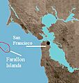
Farallon Islands, with border of Farallon Islands National Wildlife Refuge
-
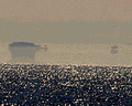
A Fata Morgana mirage of the Farallon Islands, as viewed from San Francisco
-
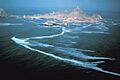
Aerial view of the Southeast Farallon Island from the south
-
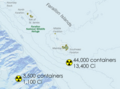
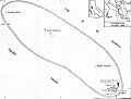
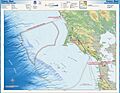
The above map indicates the approximate locations of two major nuclear waste dumping sites, according to a 1980 United States Environmental Protection Agency report.
-
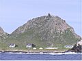
View of research station at Marine Terrace, with Farallon Island Light above
-
Aulon Island of Aulon Arch, Great Arch Rock and Sugarloaf, as seen from SEFI
-
Farallon Islands and banks further northwest
-
North Farallon Islands seen from south
-
Common murre colony on the Farallones
-
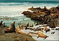
Seal Rocks, Farallons, oil painting by Albert Bierstadt (1872)
-
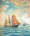
Waiting for the Pilot (Off The Farralon Islands), 1905 painting
-
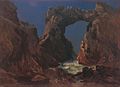
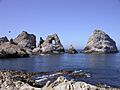
Arched rock formation with ocean water passing through

See also
 In Spanish: Los Farallones para niños
