Golden Gate International Exposition facts for kids
Quick facts for kids 1940 San Francisco |
|
|---|---|

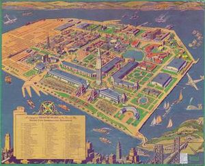
A map of the Exposition from the Official Guide Book
|
|
| Overview | |
| BIE-class | Universal exposition |
| Name | Golden Gate International Exposition |
| Area | 160 hectares (400 acres) |
| Location | |
| Country | United States |
| City | San Francisco |
| Venue | Treasure Island |
| Coordinates | 37°49′27″N 122°22′16″W / 37.8242°N 122.3710°W |
| Timeline | |
| Opening | February 18, 1939 |
| Closure | September 29, 1940 |
| Simultaneous | |
| Universal | 1939 New York World's Fair |
The Golden Gate International Exposition (GGIE) was a huge World's Fair held in San Francisco. It took place on Treasure Island in 1939 and 1940. This fair celebrated the opening of San Francisco's two amazing new bridges. The San Francisco–Oakland Bay Bridge opened in 1936, and the famous Golden Gate Bridge opened in 1937. The exposition welcomed visitors from February 18, 1939, to October 29, 1939. It then reopened from May 25, 1940, to September 29, 1940.
Contents
How the Fair Started
The idea for a World's Fair began in February 1933. Someone wrote a letter to The San Francisco News suggesting it. The goal was to celebrate the new Bay Bridge and Golden Gate Bridge.
Architects W.P. Day and George Kelham looked at different places for the fair. They considered Golden Gate Park, China Basin, Candle Stick Point, and Lake Merced. By 1934, they narrowed it down to two spots near the bridges. One was a new island built from shallow water. The other was the Presidio, which had hosted a fair in 1915.
In February 1935, they chose the area north of Yerba Buena Island. This spot would become Treasure Island. In August 1935, a plan for $10 million was proposed. This money would come from the federal WPA, a government program that created jobs during the Great Depression. In October 1935, President Franklin D. Roosevelt approved $3 million to help build the new island.
The San Francisco Bay Exposition company was officially started on July 24, 1934. The fair was planned to open on February 18, 1939, and close on December 2, 1939. Organizers hoped 20 million people would visit. Construction would employ 3,000 people, and running the fair would need 10,000 workers.
Building Treasure Island
Treasure Island is a flat, human-made island. It's connected to Yerba Buena Island and sits near where the Bay Bridge connects San Francisco and Oakland. Building Treasure Island started on February 11, 1936. Workers used 19 million cubic yards of dirt and sand to create the 385-acre site. The dredging was supposed to finish by the end of 1936.
The U.S. government built Treasure Island. It was meant to be San Francisco's main airport. This idea first came up in 1931. Large flying boats, like Pan American's China Clipper, would have used it for flights across the Pacific Ocean. However, because of World War II, the U.S. Navy took over the island. It became Naval Station Treasure Island from 1941 to 1997.
The fair closed on October 29, 1939. Plans to reopen it in 1940 were almost canceled in December 1939, but it did reopen for a second season.
What to See and Do at the Fair
Pageant of the Pacific Theme
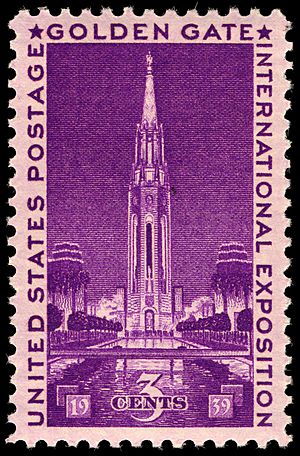
The main theme of the exposition was "Pageant of the Pacific." This meant it showed off goods and cultures from countries around the Pacific Ocean. The fair had several symbols for this theme. One was "The Tower of the Sun," a tall, impressive building. Another was an 80-foot statue of Pacifica, a goddess representing the Pacific Ocean. Architect Mark Daniels also designed a Chinese village.
President Franklin D. Roosevelt spoke about the fair's importance during its opening. He said the fair would help Pacific nations understand each other better. He believed it would also help them grow and progress.
To help people explore the city and the fair, the San Francisco Downtown Association created the 49-Mile Scenic Drive. This special route started at San Francisco City Hall. It wound through the "City by the Bay" and ended on Treasure Island.
Art and Architecture
W.P. Day was a well-known local architect. He was put in charge of all the building work for the fair. George W. Kelham was the chief architect until he passed away in 1936. Then, Arthur Brown Jr. took over.
During the fair in 1939, a master carver named John Wallace (Haida) showed visitors how to carve totem poles. This was a unique chance to see traditional art being made.
In the summer of 1940, the fair hosted the Art in Action exhibition. Here, artists worked on their creations right in front of visitors. This helped attract more people and showed how art is made.
The First NCAA Basketball Tournament
The Golden Gate International Exposition also hosted a big sports event. The California Coliseum, located at the fairgrounds, held the Western Regional Semifinal and Final rounds of the first-ever NCAA Division I Men's Basketball Tournament. The Coliseum could hold almost 9,500 people.
Teams like the Oklahoma Sooners, Oregon Webfoots, Texas Longhorns, and Utah State Aggies played there. In the first games, Oregon beat Texas, and Oklahoma beat Utah State. Then, in the regional final, the Oregon Webfoots beat the Oklahoma Sooners 55-37. This win sent Oregon to the National Championship game in Evanston, Illinois. Oregon then won the first national championship by beating the Ohio State Buckeyes 46-30.
Getting to the Fair
Getting to Treasure Island was an adventure! The Key System ran special trains from the East Bay area. These trains were called "X" trains, meaning "Exposition." They used the same routes as other Key System trains. However, instead of using the new bridge railway, they went to the old Key System ferry pier. From there, a ferry took passengers the short distance to Treasure Island. This train-ferry service stopped when the first part of the fair ended in 1939. In 1940, Key System buses, also called "X" buses, replaced the train-ferry service.
Other train companies also helped people get to the fair. The Atchison, Topeka and Santa Fe Railway started a new passenger train called the Valley Flyer. It carried passengers between Bakersfield and Oakland. Three other railroads – the Chicago, Burlington, and Quincy Railroad, Denver and Rio Grande Western Railroad, and the Western Pacific Railroad – launched the Exposition Flyer. This train service ran between Chicago and Oakland, named especially for the Golden Gate International Exposition.
What Remains Today
The Golden Gate International Exposition left a lasting impact. In October 2010, the National Building Museum in Washington, D.C. opened an exhibition. It was called Designing Tomorrow: America’s World’s Fairs of the 1930s. This exhibition, which ran until September 2011, featured the Golden Gate International Exposition.
Many of the artworks created during the Art in Action exhibition are still around. These include the huge Pan American Unity mural by Diego Rivera. Also, three wood carvings by Dudley C. Carter and two sculptures by Frederick E. Olmsted are now at City College of San Francisco.
Another famous artwork, The Fauna and Flora of the Pacific mural by Miguel Covarrubias, is on display. You can see it at the de Young museum in San Francisco. This colorful, oversized map shows the four continents around the Pacific Ocean. It features examples of their plants and animals, all swirling in the ocean with sea creatures.
Images for kids
 | Janet Taylor Pickett |
 | Synthia Saint James |
 | Howardena Pindell |
 | Faith Ringgold |


