
Castle Peak (California) facts for kids
Quick facts for kids Castle Peak |
|
|---|---|

Castle Peak from Andesite Peak
|
|
| Highest point | |
| Elevation | 9,109 ft (2,776 m) NAVD 88 |
| Prominence | 1,343 ft (409 m) |
| Listing | Sierra Peaks Section |
| Geography | |

Castle Peak
Location in California

Castle Peak
Location in the United States
|
|
| Location | Nevada County, California, U.S. |
| Parent range | Sierra Nevada |
| Topo map | USGS Norden |
| Climbing | |
| Easiest route | Exposed scramble (class 3) |
Castle Peak is a cool mountain in California. It is part of the big Sierra Nevada mountain range. You can find it close to a major highway called I-80, near Donner Pass. It is also not far from the Nevada border.
This mountain is inside the Tahoe National Forest, a large protected area. It is even right next to a famous hiking path called the Pacific Crest Trail. Castle Peak gets its name because its pointy shape looks a bit like an old castle.
Mountain Weather
The weather at Castle Peak is like what you would find in high mountains. This is called an alpine climate zone. Most of the weather comes from the Pacific Ocean. These weather systems travel east toward the Sierra Nevada mountains.
When weather fronts hit the tall peaks, the air is forced to rise. As the air goes up, it cools down and drops its moisture. This means lots of rain or snow falls on the mountains. Donner Pass, which is nearby, gets about 51.6 inches (131 cm) of rain each year. It also gets a huge amount of snow, averaging about 411.5 inches (10.45 meters) per year. This makes it one of the snowiest places in the United States.
Gallery
-
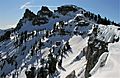
Castle Peak from the south ridge. The highest summit is on the left.
-
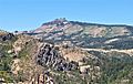
South-southeast view
-
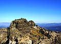
View of Castle Peak's summit, from the end of the Castle Peak Summit Trail.
.jpg)

.JPG)
