
Donner Pass facts for kids
Quick facts for kids Donner Pass |
|
|---|---|

Panorama of view to the east in July
|
|
| Elevation | 7,056 ft (2,151 m) |
| Traversed by | California Trail Lincoln Highway Overland Route |
| Location | Nevada County, California, United States |
| Range | Sierra Nevada |
| Coordinates | 39°18′52″N 120°19′37″W / 39.31444°N 120.32694°W |

Location in California
|
|
Donner Pass is a famous mountain pass in the northern Sierra Nevada mountains. It's about 7,056 feet (2,151 meters) high and sits above Donner Lake, about 9 miles (14 km) west of Truckee, California. The pass has a steep side if you approach from the east, and a more gradual slope from the west.
This pass has been a very important route for many years. It was used by early settlers on the California Trail, and later by major transportation routes like the First Transcontinental Railroad and the Lincoln Highway. Today, Interstate 80 also goes near it. The pass is named after the Donner Party, a group of settlers who got stuck here in heavy snow in 1846.
Now, the area around Donner Pass is a popular spot for outdoor fun. You can find several beautiful alpine lakes and ski resorts like Donner Ski Ranch and Sugar Bowl Ski Resort. Small towns like Kingvale and Soda Springs are also nearby.
Contents
History of Donner Pass
Early Travelers and the Donner Party
To reach California from the east, pioneers in wagons had to cross the tough Sierra Nevada mountains. In 1844, the Stephens-Townsend-Murphy Party was the first group of settlers to use this pass. They followed the Truckee River and found a low spot in the mountains near what is now Donner Lake.
The pass later got its name from the Donner Party. In November 1846, this group of settlers heading to California found their path blocked by deep snow. They were forced to spend the winter on the east side of the mountains. Out of 81 settlers, only 45 survived to reach California. They faced extreme hardship and had to make difficult choices to survive the harsh winter.
Train Stranded in a Blizzard
On January 13, 1952, a passenger train called the City of San Francisco got stuck in a huge blizzard. It was about 17 miles (27 km) west of Donner Pass. The snow was so deep that the train could not move forward or backward.
The 222 passengers and crew were stranded for three days. Finally, the nearby highway was cleared enough for cars to reach them. They were then taken to a lodge a few miles away.
Building the Railroad Over the Sierra
Central Pacific Railroad's Challenge

In 1868, the Central Pacific Railroad (CPRR) finally managed to build a railroad over the Sierra Nevada mountains. This was a huge achievement after almost three years of hard work. Most of the workers were Chinese laborers.
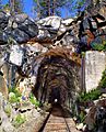
The most difficult part of building the railroad was at Donner Pass. Workers had to dig four tunnels, build miles of snow sheds (covered structures to protect tracks from snow), and create two "Chinese Walls" (stone retaining walls). This allowed trains to cross the Sierra for the first time, making it possible to transport many passengers and goods.
The Summit Tunnels

The original railroad route over the summit was designed by engineers like Theodore D. Judah and Lewis M. Clement. This first track, which included Tunnel #6, was used daily starting in June 1868.
However, in 1993, the Southern Pacific Railroad (which later merged with Union Pacific Railroad) stopped using this original track section. They found it too difficult and expensive to maintain during the harsh Sierra winters.
Now, all trains use a different track, Track #2, which crosses the summit about 1 mile (1.6 km) south of Donner Pass. This track goes through a very long tunnel called Tunnel No. 41, which is 10,322 feet (3,146 meters) long. This tunnel was opened in 1925 and is easier to maintain.
Modern Upgrades
Recently, there have been major upgrades to the railroad line over Donner Pass. These improvements help larger container trains travel through the mountains. For example, 15 tunnels between Rocklin and Truckee were made taller. This allows trains carrying two stacked containers to pass through. These upgrades help connect California with the rest of the country for trade.

.jpg)
Highways Over the Sierra


The Lincoln Highway, which was the first road to cross America, goes over Donner Pass. This route was also part of the Victory Highway.
Later, Interstate 80 was built through this area in the early 1960s. I-80 generally follows the old US 40 route through the Sierra Nevada. However, I-80 crosses the Sierra crest at a place called Euer Saddle, which is about 2 miles (3.2 km) north of Donner Pass.
Euer Saddle is often called "Donner Summit" by the California Department of Transportation (CalTrans). It is about 7,240 feet (2,207 meters) high, which is about 150 feet (46 meters) higher than Donner Pass. But Euer Saddle is wider and has a gentler slope, which made it easier to build a modern interstate highway. The old 1920s highway over Donner Pass is still there and can be used as a scenic drive.
Weather at Donner Pass
Winter weather at Donner Pass can be very harsh. The area gets a lot of rain and snow, especially in winter. On average, Donner Pass receives about 411.5 inches (10.45 meters) of snow each year. This makes it one of the snowiest places in the United States.
Sometimes, the total snowfall can be even higher. It has gone over 775 inches (19.7 meters) four times since 1880, and even topped 800 inches (20.3 meters) in 1938 and 1952. Because of all this snow, ski resorts like Boreal were built nearby.
Winds in the pass can also be very strong, often reaching over 100 miles per hour (160 km/h) during winter storms. Temperatures can drop below 0°F (-18°C) several times a year. The coldest temperature ever recorded in California, -45°F (-43°C), was in January 1937 at Boca, east of Truckee. The severe winter of 1846–47 was a major reason for the difficulties faced by the Donner Party.
Fun Activities at Donner Pass

Donner Pass is a great place for outdoor activities all year round. In summer, you can go backpacking and rock climbing. In winter, it's perfect for downhill skiing and cross-country skiing, as well as ice climbing.
The old tunnel built by the Central Pacific Railroad is now a popular spot for graffiti art. The area also became famous in the 1990s for snowboarding films. Its easy access to both frontcountry (areas with easy access) and backcountry (more remote areas) terrain makes it a favorite for snowboarders. However, it's important to be careful, as there have been some avalanche accidents in the area.
Images for kids
-
(Composite image with the tracks removed in 1993 digitally restored)
