Rocklin, California facts for kids
Quick facts for kids
Rocklin, California
|
|
|---|---|

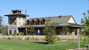
Amtrak station and Chamber of Commerce, Rocklin
|
|
| Motto(s):
"A Family Community"
|
|

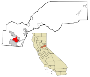
Location in Placer County and the state of California
|
|
| Country | |
| State | |
| County | Placer |
| Incorporated | February 24, 1893 |
| Government | |
| • Type | Council-manager system |
| Area | |
| • Total | 19.83 sq mi (51.37 km2) |
| • Land | 19.81 sq mi (51.31 km2) |
| • Water | 0.02 sq mi (0.06 km2) |
| Elevation | 249 ft (76 m) |
| Population
(2020)
|
|
| • Total | 71,601 |
| • Density | 3,610.7/sq mi (1,393.83/km2) |
| Demonym(s) | Rocklinite |
| Time zone | UTC-8 (PST) |
| • Summer (DST) | UTC-7 (PDT) |
| ZIP codes |
95677, 95765
|
| Area code(s) | 916, 279 |
| FIPS code | 06-62364 |
| GNIS feature ID | 0277586 |
Rocklin is a city located in Placer County, California, in the United States. It's about 22 miles (35 km) northeast of Sacramento. Rocklin is part of the larger Sacramento area. It shares its borders with nearby towns like Roseville, Granite Bay, Loomis, and Lincoln. In 2020, about 71,601 people lived in Rocklin.
Contents
Rocklin's Early History
Before the California Gold Rush, the Nisenan Maidu people lived in this area. They had permanent villages and also set up summer camps along the rivers. These rivers were later used by miners to find gold.
In 1827, explorer Jedediah Smith and a group of fur trappers traveled through the Sacramento Valley. They saw many Maidu villages along the riverbanks. Sadly, the Nisenan people were among the first California Native American tribes to disappear. This happened because settlers took away their traditional food sources, homes, and hunting grounds.
Mining for Gold and Granite
During the 1850s, miners searched for gold in streams and rivers, including Secret Ravine. This ravine runs right through what is now Rocklin. You can still see piles of rock left behind by the gold dredgers today. These piles are located between Roseville and Loomis, southeast of Interstate 80.
Later, Secret Ravine was mined for granite. Some of this granite was even used to build the base of the California Capitol Building. The first time this rock was officially used was for Fort Mason in San Francisco in 1855. Before railroads, the heavy granite was moved by oxcarts.
In 1860, the U.S. Census counted 440 people living in the Secret Ravine area. About 16% of them were born in Ireland, and most worked as miners. Until 1864, the area was still called Secret Ravine or "the granite quarries at the end of the tracks."
The Railroad Arrives
Rocklin's story is closely connected to the transcontinental railroad. In 1862, the Pacific Railroad Act gave land near Secret Ravine to the Central Pacific Railroad. By 1864, the Central Pacific Railroad extended its tracks from Newcastle to Secret Ravine. They named the area Rocklin because of its granite quarries. It became a place where trains could refuel and get water.
In 1867, the Central Pacific built a roundhouse here. When the transcontinental railroad was finished in 1869, much more train traffic passed through Rocklin. The 1870 census showed that Rocklin had grown to 542 residents. Most of the Irish immigrants who had been miners now worked for the railroad.
In 1908, the Central Pacific moved its railroad facilities from Rocklin to Roseville. Roseville had more space for the railroad to grow. The Roseville site is still used today and is one of the largest rail facilities near the U.S. West Coast.
Chinese Workers and New Settlers
In 1869, a group of Chinese railroad workers who had finished their jobs moved to Secret Ravine. They mined and grew vegetables to sell locally. However, in September 1876, the Chinese community was forced to leave after some Chinese individuals were accused of a crime near Rocklin. Even in 1974, that area was still known as China Gardens.
The Rocklin post office opened in 1868. People from Finland started settling in Rocklin in the 1870s. In the early 1900s, Spanish settlers arrived, some coming by way of Hawaii. Rocklin officially became a city in 1893.
Rocklin's Geography and Climate
Rocklin covers an area of about 19.6 square miles (50.8 square kilometers). Only a very small part, about 0.05 square miles (0.13 square kilometers), is water.
Rocklin's Climate
Rocklin has a hot-summer Mediterranean climate. This means it has cool, wet winters and hot, dry summers. Summers are very hot, with an average high temperature in July of about 94°F (34°C). It rarely rains in the summer. Winters are cool, with an average temperature in December of about 47°F (8°C), and they get a lot of rain. It almost never snows in Rocklin.
The temperature can change a lot between day and night. In January, the difference is about 14°F (8°C), but in July, it can be as much as 33°F (18°C).
| Climate data for Rocklin, California | |||||||||||||
|---|---|---|---|---|---|---|---|---|---|---|---|---|---|
| Month | Jan | Feb | Mar | Apr | May | Jun | Jul | Aug | Sep | Oct | Nov | Dec | Year |
| Record high °F (°C) | 76 (24) |
82 (28) |
90 (32) |
97 (36) |
107 (42) |
115 (46) |
115 (46) |
118 (48) |
114 (46) |
105 (41) |
88 (31) |
80 (27) |
118 (48) |
| Mean daily maximum °F (°C) | 53.7 (12.1) |
59.3 (15.2) |
64.5 (18.1) |
71.2 (21.8) |
79.8 (26.6) |
89.0 (31.7) |
96.5 (35.8) |
95.0 (35.0) |
89.2 (31.8) |
78.5 (25.8) |
65.4 (18.6) |
54.7 (12.6) |
74.7 (23.7) |
| Daily mean °F (°C) | 44.3 (6.8) |
48.4 (9.1) |
52.2 (11.2) |
57.3 (14.1) |
64.1 (17.8) |
71.3 (21.8) |
77.2 (25.1) |
75.6 (24.2) |
70.9 (21.6) |
62.4 (16.9) |
52.0 (11.1) |
44.9 (7.2) |
60.1 (15.6) |
| Mean daily minimum °F (°C) | 34.9 (1.6) |
37.6 (3.1) |
39.9 (4.4) |
43.4 (6.3) |
48.3 (9.1) |
53.7 (12.1) |
57.9 (14.4) |
56.2 (13.4) |
52.6 (11.4) |
46.2 (7.9) |
38.7 (3.7) |
34.9 (1.6) |
45.4 (7.4) |
| Record low °F (°C) | 14 (−10) |
20 (−7) |
23 (−5) |
27 (−3) |
29 (−2) |
34 (1) |
34 (1) |
33 (1) |
29 (−2) |
25 (−4) |
20 (−7) |
14 (−10) |
14 (−10) |
| Average precipitation inches (mm) | 4.89 (124) |
3.86 (98) |
3.27 (83) |
1.79 (45) |
0.76 (19) |
0.28 (7.1) |
0.03 (0.76) |
0.03 (0.76) |
0.32 (8.1) |
1.25 (32) |
2.57 (65) |
3.75 (95) |
22.80 (579) |
| Average precipitation days | 10 | 9 | 7 | 5 | 3 | 1 | 0 | 0 | 1 | 3 | 6 | 8 | 53 |
| Source: Western Regional Climate Center | |||||||||||||
Rocklin's Population Changes
| Historical population | |||
|---|---|---|---|
| Census | Pop. | %± | |
| 1870 | 542 | — | |
| 1880 | 624 | 15.1% | |
| 1890 | 1,056 | 69.2% | |
| 1900 | 1,050 | −0.6% | |
| 1910 | 1,026 | −2.3% | |
| 1920 | 643 | −37.3% | |
| 1930 | 724 | 12.6% | |
| 1940 | 795 | 9.8% | |
| 1950 | 1,155 | 45.3% | |
| 1960 | 1,495 | 29.4% | |
| 1970 | 3,039 | 103.3% | |
| 1980 | 7,344 | 141.7% | |
| 1990 | 19,033 | 159.2% | |
| 2000 | 36,330 | 90.9% | |
| 2010 | 56,974 | 56.8% | |
| 2020 | 71,601 | 25.7% | |
| 2023 (est.) | 73,472 | 29.0% | |
| U.S. Decennial Census | |||
Population in 2010
According to the 2010 census, Rocklin had 56,974 people. The city had about 2,908 people per square mile (1,123 people per square kilometer).
Most people in Rocklin were White (82.6%). There were also people who identified as African American (1.5%), Native American (0.7%), Asian (7.2%), Pacific Islander (0.3%), and other races. About 5% of the population identified with two or more races. People of Hispanic or Latino background made up 11.5% of the population.
Most people (98.9%) lived in regular homes. About 40.5% of homes had children under 18. The average household had 2.71 people. The average family had 3.18 people.
The median age in Rocklin was 36.7 years old. For every 100 females, there were about 94 males.
Population in 2000
In the 2000 census, Rocklin had 36,330 people living in 13,258 households. About 42.6% of these households had children under 18. The average household size was 2.74 people, and the average family size was 3.15 people.
The median income for a household in Rocklin was $79,274. This means half of the households earned more than this, and half earned less. About 4.5% of the population lived below the poverty line.
Rocklin's Economy
Granite mining, which was once very important to Rocklin, stopped in 2004. Today, the top employers in Rocklin include large international companies, retail stores, schools, and government jobs.
In April 2016, Rocklin had about 30,100 people working, and the unemployment rate was 4.4%. This means most people who wanted a job had one. Also, about 40% of Rocklin citizens over 25 years old have a college degree or higher.
You can find shopping, entertainment, and dining at places like the Blue Oaks Town Center. This is a large shopping area with many well-known stores along the Highway 65 corridor. Other shopping centers include Rocklin Commons and Rocklin Crossings, which have stores like Target, Walmart, and Bass Pro Shop, located near Interstate 80. There's also a part of Granite Drive near Interstate 80 called Toy Row. Here you can find high-end car dealerships, RV and boat stores, and a local antique mall.
The city has four special areas with different building styles: the University District, Granite District, College District, and Quarry District.
Education in Rocklin
The Rocklin area has many schools. There are 13 elementary schools, two middle schools, and two high schools. There are also two alternative education schools. All these schools are part of the Rocklin Unified School District. Rocklin is also home to campuses for Sierra College and William Jessup University.
Transportation in Rocklin
Interstate 80 and State Route 65 are two major highways that meet in Rocklin. Historic U.S. Route 40 also runs through the town. The Rocklin Amtrak station is served by Amtrak California's Capitol Corridor train route, which connects cities in Northern California.
Notable People from Rocklin
- Brandon Aiyuk, a wide receiver for the San Francisco 49ers football team.
- Johnny Davis, a kickboxer.
- Kevin Kiley, a politician.
- John Romero, a video game developer.
- Logan Webb, a pitcher for the San Francisco Giants baseball team.
- Karyn White, a pop singer.
See also
 In Spanish: Rocklin, California para niños
 | James B. Knighten |
 | Azellia White |
 | Willa Brown |


