
Truckee River facts for kids
Quick facts for kids Truckee River |
|
|---|---|

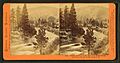
The Truckee River just east of Truckee, California
|
|

Map of the Pyramid Lake drainage basin
|
|
| Other name(s) | Salmon Trout River |
| Country | United States |
| State | California, Nevada |
| Physical characteristics | |
| Main source | Lake Tahoe Sierra Nevada, California 6,233 ft (1,900 m) 39°10′3″N 120°8′39″W / 39.16750°N 120.14417°W |
| River mouth | Pyramid Lake Nevada 3,793 ft (1,156 m) 39°51′27″N 119°26′53″W / 39.85750°N 119.44806°W |
| Length | 121 mi (195 km) |
| Basin features | |
| Basin size | 3,060 sq mi (7,900 km2) |
The Truckee River is a river in the U.S. states of California and Nevada. It flows northeast for about 121 miles (195 km). The Truckee River is the only river that flows out of Lake Tahoe. It drains part of the high Sierra Nevada mountains. The river ends by emptying into Pyramid Lake in the Great Basin. Its water is very important for watering farms along its path and in nearby areas.
Contents
Naming the Truckee River
When explorers John C. Frémont and Kit Carson first explored the Truckee River in 1844, they called it the Salmon Trout River. This was because of the huge Lahontan cutthroat trout fish that swam up the river from Pyramid Lake to lay their eggs.
However, the river was later named after a Paiute chief. This chief, known as Truckee, guided a group of travelers in 1844. He led them from the Humboldt River to California using the Truckee River, Donner Lake, and Donner Pass. The travelers were very thankful for his help and named the river after him. The chief's real name might have been Tru-ki-zo, which may have sounded like "Truckee" to the travelers.
River's Path and Water Area


The Truckee River starts at the outlet of Lake Tahoe. This is where a dam is located on the northwest side of the lake, near Tahoe City, California. The river generally flows northeast through the mountains to Truckee, California. Then, it sharply turns east and flows into Nevada. It passes through the cities of Reno and Sparks.
Near Fernley, the river turns north. It flows along the east side of the Pah Rah Range. Finally, it empties into the southern end of Pyramid Lake. Pyramid Lake is a leftover from a much larger ancient lake called Lake Lahontan. The river ends its journey within the Pyramid Lake Indian Reservation.
The area of land that collects water for the Truckee River is called its drainage basin. This basin covers about 3,060 square miles (7,900 km2). About 2,300 square miles (6,000 km2) of this area is in Nevada. The middle part of the river's watershed includes about 15 miles (24 km) of the river and its smaller streams. These streams flow from Tahoe City, through the town of Truckee, to the Nevada state line.
Many smaller streams flow into the Truckee River. Some major ones in California include Bear Creek, Squaw Creek, Cabin Creek, Pole Creek, Donner Creek, Trout Creek, Martis Creek, Prosser Creek, and the Little Truckee River. Important lakes and reservoirs in the California part of the watershed are Lake Tahoe, Donner Lake, Independence Lake (California), Webber Lake, Boca Reservoir, Stampede Reservoir, Prosser Creek Reservoir, and Martis Creek Reservoir. In the lower part of the watershed, Steamboat Creek is the main stream that flows into the Truckee River.
How the River is Managed

Like many rivers in the western United States, the Truckee River's flow is carefully managed. Most of the river's water is used through a system of water rights. These rights were set in 2015 by the Truckee River Operating Agreement. Sometimes, during dry periods, there isn't enough water for everyone who has rights to it. This can lead to disagreements.
In the early 1900s, a project called the Newlands Reclamation Act changed how the river flowed. It moved some of the Truckee River's water to the Carson River watershed. Today, the Truckee–Carson Irrigation District oversees this. They divert about one-third of the river's water at the Derby Dam. This water goes to the Lahontan Valley to water crops like alfalfa.
Truckee River water also goes to towns around Lake Tahoe, the cities of Reno and Sparks, and the Pyramid Lake Paiute Indian Reservation. The United States Fish and Wildlife Service uses some water to help endangered fish, like the cui-ui, lay their eggs. They also use it to help during dry times.
River Animals and Plants (Ecology)
Beavers were brought back to the Truckee River watershed and the Tahoe Basin between 1934 and 1949. This was done by the California Department of Fish and Game and the United States Forest Service. The goal was to help restore wetlands and prevent damage to streams.
There is evidence that beavers lived here naturally a long time ago. The Washo and northern Paiute tribes have words for beaver in their languages. An explorer named Stephen Powers reported in 1876 that the northern Paiute used beaver fur and that beavers were part of their creation stories. Also, a fur trapper named Stephen Hall Meek "set his traps on the Truckee River in 1833," which suggests beavers were present.
Beaver dams are good for the environment. They can increase the number and size of fish in streams. Studies have shown that plants like aspen and cottonwood have grown more near beaver dams. Also, beaver dams help clean the water by removing dirt and pollution. This makes the water clearer. If beaver dams are removed, water clarity can get worse. Flooding from beaver dams can be managed with special devices.
Fun Activities on the River (Recreation)


The Truckee River is a popular place for fun activities. People enjoy whitewater rafting and fly fishing. A common rafting trip is the River Ranch Run. It starts from Lake Tahoe's outlet gates and goes for about 3 miles (4.8 km). This run has mostly easy rapids.
In downtown Reno, the river has a special half-mile park for whitewater activities. It's mainly used for kayaking.
The Truckee River is the biggest river in western Nevada. Many people come here to fish. The Nevada Department of Wildlife (NDOW) aims for people to catch one to two fish per hour. To help with this, NDOW stocks the river with 105,000 trout each year. About 70,000 of these are native Lahontan cutthroat trout. The rest are Rainbow trout, which are not native. The river also has a healthy population of Brown trout that reproduce on their own.
Water Quality and River Health
The Truckee River is very important for water quality studies. This is because it starts in the Lake Tahoe Basin and is home to endangered fish. Detailed studies began in the mid-1980s.
The United States Environmental Protection Agency helped create a special computer model. This model, called DSSAM, helps understand how land use and wastewater affect the river. It looks at things like nitrogen, phosphate, and oxygen levels in the water. This model helps make decisions to improve the river's water quality and help the plants and animals that live there. It also helps understand how the river affects Pyramid Lake.
Images for kids
-
The Truckee River at Verdi, Nevada, when the Central Pacific Railroad reached the area in 1868
-
The Truckee River in Truckee, California, with Donner Creek flowing in from the right
-
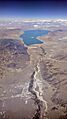
Aerial view from the south of the Truckee River where it drains to Pyramid Lake
-
Rafting and tubing for fun on the Truckee River in Reno, Nevada, USA, on the 4th of July 2018
-
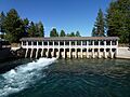
The start of the Truckee River at Lake Tahoe Dam
-
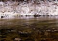
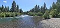
The Truckee River near Truckee, California.
