Independence Lake (California) facts for kids
Quick facts for kids Independence Lake |
|
|---|---|

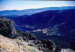
The upper end of Independence Lake, as seen from the south slope of Mount Lola
|
|
| Coordinates | 39°26′33″N 120°18′36″W / 39.44250°N 120.31000°W |
| Part of | Little Truckee River watershed, Truckee River, Great Basin |
| Max. length | 2.4 miles (3.9 km) |
| Max. width | 0.5 miles (0.8 km) |
| Surface area | 700 acres (280 ha) |
| Max. depth | 145 feet (44 m) |
| Shore length1 | 5.8 miles (9.3 km) |
| Surface elevation | 6,949 feet (2,118 m) |
| 1 Shore length is not a well-defined measure. | |
Independence Lake is a beautiful natural lake in California. It is located high up in the Sierra Nevada mountains. This lake is special because it has not been changed much by human development.
The lake sits at an elevation of 6,949 feet (2,118 m). It is part of the Truckee River basin. The Nature Conservancy owns the land around the lake. They manage it as the Independence Lake Preserve. Their goal is to protect nature and allow people to enjoy it with low impact.
Contents
Where is Independence Lake?
Independence Lake is in a narrow valley. This valley was carved by a glacier long ago. Mount Lola is the highest mountain nearby. It rises from the north side of the valley. Carpenter Ridge is on the south side of the lake.
Upper Independence Creek flows into the lake from the west. The lake's water flows out from its east end. This water forms Independence Creek. This creek then joins the Little Truckee River and later the Truckee River. The lake is about 2.4 miles (3.9 km) long. It is also about half a mile (0.8 km) wide.
The closest big town is Truckee. It is about 20 miles (32 km) south by road. The smaller town of Sierraville is about 14 miles (23 km) north by road.
How Independence Lake Was Formed
Independence Lake lies in a deep valley. This valley was carved out by a large glacier. This glacier moved down the eastern side of Mount Lola a very long time ago.
Animals and Plants at Independence Lake

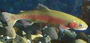
Independence Lake is very important for fish. It is one of only two places where a special fish lives. This fish is called the Lahontan cutthroat trout (Oncorhynchus clarkii henshawi). This trout is a threatened species. This means it is in danger of disappearing forever. It used to live in many more places.
Other fish in the lake include the brook trout, brown trout, kokanee salmon, and mountain whitefish. Independence Lake is unique. It still has all its native fish species. A dam at the lake helps keep out fish that are not native. This protects the special fish that belong there.
The area around the lake is very natural and clean. It has many types of plants found in the Sierra Nevada upper montane forest. Tall conifer trees grow here. These include the white fir and Jeffrey pine. Higher up, you can also find red fir.
Some parts of the forest have aspen trees. But these aspens are threatened. The thick conifer trees block the sunlight that aspens need to grow. People think that stopping forest fires for many years has changed the forest. This has allowed the white firs to grow more. It has also made it harder for aspens and Jeffrey pines to thrive.
History of Independence Lake
The Washoe people have lived near Independence Lake for about 9,000 years. They believed the lake was bottomless.
In the mid-1800s, Europeans became interested in the lake. No one is completely sure who named the lake. But everyone agrees it was named on Independence Day. Many people believe Lola Montez named the lake in 1853. Montez was a famous actress and dancer. She traveled the world and settled in California. Mount Lola, near the lake, is also named after her. Another person, Augustus Moore, said he named the lake in 1862.
In 1879, a dam was built at the lake for the first time.
A big wildfire in 1945 burned many trees around the lake. After the logging that followed, a new dam was built. This dam made the lake hold more water. In 1947, Sierra Pacific Power Company bought the land. They then closed the area to most public visitors.
In the 1970s, Disney wanted to build a ski resort here. They had tried to build a resort in another area, but it was difficult. So, in 1971, the Forest Service suggested Independence Lake. Disney teamed up with Sierra Pacific in 1974. They started planning a resort.
However, many local people did not like the idea. They protested with signs. They worried about the environment. They also feared that too many people would come to the quiet area. This would change their small towns. In 1978, Disney decided to stop their plans at Independence Lake.
In 2008, the United States Congress passed a law. It set aside money to buy the land around Independence Lake. This was to protect the fish and water. In April 2010, The Nature Conservancy bought the land from Sierra Pacific. This created the Independence Lake Preserve.
Protecting and Managing Independence Lake
The Nature Conservancy allows people to visit the lake during the day. You can walk in all year. However, the road is not cleared of snow in winter. So, it can be hard to reach the lake for much of winter and spring.
To keep the lake safe from harmful plants and animals, you cannot bring your own boats. This includes kayaks and canoes. But during summer, you can use free kayaks, float tubes, and small motorboats provided by The Nature Conservancy. Motorboats are available on certain weeks.
The Truckee Meadows Water Authority controls the top 28 feet (8.5 m) of the lake's water. They manage this water using the dam. This water is part of the Truckee River Project. It helps supply drinking water to the cities of Reno and Sparks.
 | Shirley Ann Jackson |
 | Garett Morgan |
 | J. Ernest Wilkins Jr. |
 | Elijah McCoy |


