El Escorpión Park facts for kids
Quick facts for kids Castle Peak |
|
|---|---|
| kas'ele'ew | |

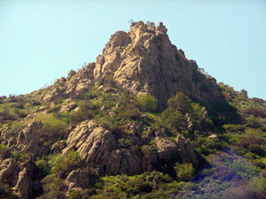
Castle Peak from the east
|
|
| Highest point | |
| Elevation | ~1,475 feet (450 m) |
| Geography | |
| Location | West Hills, Los Angeles, California, United States |
| Parent range | Simi Hills |
| Climbing | |
| Easiest route | southern route |
El Escorpión Park is a fun, three-acre park located in the Simi Hills area. You can find it in the western part of the San Fernando Valley, specifically in the West Hills neighborhood of Los Angeles, California. A cool landmark in the park is Escorpión Peak, also known as Castle Peak. This rocky peak is about 1,475 feet (450 meters) tall and can be seen from most parts of the park and the nearby community. Its original name in the Chumash language was kas'ele'ew.
| Top - 0-9 A B C D E F G H I J K L M N O P Q R S T U V W X Y Z |
Visiting El Escorpión Park
The entrance to El Escorpión Park is at the western end of Vanowen Street. It's west of Valley Circle Boulevard in West Hills.
The park is open every day, from when the sun rises until it sets. You can enjoy many activities here, like walking, hiking, rock climbing, mountain biking, and even horseback riding (called equestrian use). If you have a dog, they are welcome, but please keep them on a leash. Be aware that Rattlesnakes live in the area, so always watch where you step and place your hands. Motor vehicles and motorbikes are not allowed in the park.
The Los Angeles Department of Recreation and Parks takes care of El Escorpión Park.
Exploring the Trails
Climbing Castle Peak
Hiking to the top of Castle Peak is a real challenge! The trail on the south side is rough and steep. It's not recommended for new hikers. The very last part of the climb means you'll be scrambling over large rocks and boulders. It's important to be careful to avoid slips or falls.
Experienced hikers will love this climb. You gain about 561 feet (171 meters) in height over a short distance. You can easily spot the start of the trail in Moores Canyon at the base of the peak. About three-quarters of the way up, the trail becomes harder to see. The easiest path turns left (west) at that point.
Other Park Trails
- From the summit of Castle Peak, a trail goes west along the ridge to a small grassy area. From the southern edge of this meadow, you get amazing views! You can see Moores Canyon, the lower part of El Escorpión Park, and the Upper Las Virgenes Canyon Open Space Preserve. You'll also get a wide view of the Santa Monica Mountains, Simi Hills, Santa Susana Mountains, San Gabriel Mountains, and the San Fernando Valley. Another trail heads north from here towards Bell Creek and the community of Bell Canyon.
- Did you know that in 1769, the Juan Bautista de Anza expedition passed through this area? This was the first time Europeans explored Las Californias by land. Today, the U.S. National Park Service's Juan Bautista de Anza National Historic Trail runs through Moores Canyon in the park. It starts from the Vanowen Street end and continues west into the Upper Las Virgenes Canyon Open Space Preserve.
- Near the cyclone fence in upper Moores Canyon, there's a small area for mountain bikes. It has easy jumps for practice. Several trails go northwest from this spot, circling the western side of Castle Peak. These trails connect to the path that goes down Bell Canyon along Bell Creek, leading to Bell Creek Park. You can even make a full loop back to the Victory Trailhead.
- There are many other trails to explore in the area. You can see them on the map display at the Victory Boulevard trailhead. Bell Canyon Park in Los Angeles City is right next to El Escorpión Park to the north. It has trails along riparian Bell Creek, past the community of Bell Canyon, and connects to a longer northern route up Castle Peak. The huge 3,000-acre (12 square kilometer) Upper Las Virgenes Canyon Open Space Preserve is next to El Escorpión Park on the southwest. It offers miles of trails and connects even further west to the Santa Monica Mountains Conservancy Cheseboro/Palo Comado Canyon Park's trails.
Park History
Castle Peak got its name from an older Native American name. The Ventureño Chumash people called the peak Kas'ele'ew (or Kas'elew) in their Chumash language. The American name "Castle Peak" is a changed version of this original name.
Native Americans lived in this area for about 8,000 years. These were the Tongva-Fernandeño and Chumash-Ventureño tribes. They lived in the Simi Hills and near the streams that flow into the Los Angeles River. A village called Hu'wam (a Ventureño Chumash placename) was located at the base of Castle Peak. It was along what is now Bell Creek, near the entrance to Bell Canyon. This village was an important meeting and trading spot for the Chumash with the Tongva-Fernandeño and Tataviam-Fernandeño people.
Nearby Parks
See also
 In Spanish: Parque El Escorpión para niños
 | Aurelia Browder |
 | Nannie Helen Burroughs |
 | Michelle Alexander |

