West Hills, Los Angeles facts for kids
Quick facts for kids
West Hills
|
|
|---|---|
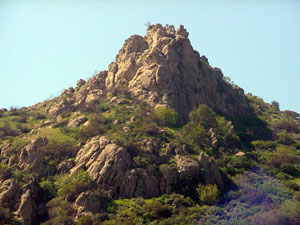
Escorpión Peak (also known as Castle Peak) (1,475 feet/450 m)—east face view from West Hills
|
|
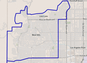
West Hills as shown by the Los Angeles Times
|
|
| Country | United States |
| State | California |
| County | Los Angeles |
| City | Los Angeles |
| Owensmouth | 1912 |
| Canoga Park | 1930 |
| West Hills | 1987 |
| Area | |
| • Total | 8.53 sq mi (22 km2) |
| Elevation | 900 ft (274 m) |
| Population
(2022)
|
|
| • Total | 32,267 |
| Time zone | UTC-8 (PST) |
| • Summer (DST) | UTC-7 (PDT) |
| ZIP code |
91304 & 91307
|
| Area code(s) | 818 & 747 |
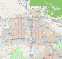
West Hills is a neighborhood located in the western part of the San Fernando Valley in Los Angeles, California. It is surrounded by mountains to the west. Other Los Angeles neighborhoods like Chatsworth are to the north, Canoga Park to the east, and Woodland Hills to the south.
This area was once home to many Native American tribes. Later, during the Spanish and Mexican times, it was part of the Mission San Fernando Rey de España. In the American era, West Hills was part of a town called Owensmouth, which changed its name to Canoga Park in 1930. West Hills officially became its own neighborhood in 1987.
West Hills has several city parks and is mostly a residential area, meaning many people live there. You can also find some churches and a few shopping areas. There are 13 schools in West Hills, including two private high schools.
Contents
Geography of West Hills
Where is West Hills Located?
West Hills is in the western part of the San Fernando Valley in Los Angeles County. It's about a 45-minute drive from downtown Los Angeles, depending on traffic. You can reach it from U.S. 101 (the Ventura Freeway).
According to a project by the Los Angeles Times in 2008, West Hills is next to the Chatsworth Reservoir to the north. To the east is Canoga Park, and to the south is Woodland Hills. On the southwest, you'll find Hidden Hills, and to the west, Bell Canyon in Ventura County.
 |
Santa Susana Field Laboratory & Simi Valley |
Chatsworth | Northridge |  |
| Bell Canyon & Simi Hills |
Canoga Park | |||
| Hidden Hills & Ahmanson Ranch Park | Woodland Hills | Warner Center |
Water Resources and Local Creeks
Bell and Dayton creeks in West Hills are some of the starting points for the Los Angeles River. These creeks, along with others, carry rainwater and runoff from the neighborhoods into the Los Angeles River. Even though many creeks now flow through concrete channels, they are still important for local wildlife.
Some of these creeks start near the Santa Susana Field Laboratory in the Simi Hills. This site is being cleaned up because it was used for testing rocket engines and nuclear research. The cleanup makes sure the water is safe for everyone.
West Hills has a climate similar to other places in the western San Fernando Valley. Summers are warm and dry, with temperatures often reaching around 96 degrees Fahrenheit in August.
People and Population in West Hills
West Hills Population in 2022
In 2022, about 32,267 people lived in West Hills. Most residents were White (60.52%), followed by Asian (15.73%), Black (4.56%), and Native American (0.75%). About 12.15% of the population identified as Hispanic or Latino.
West Hills Population in 2010
In 2010, there were 38,814 people living in West Hills. The population was mostly White (78.89%), with a significant number of Asian residents (11.97%). About 9.26% of the people were Hispanic.
West Hills Population in 2000
The 2000 census counted 30,814 people in West Hills. This area had a lower population density compared to other parts of Los Angeles. The average age of residents was 39, which was considered older than in many other city neighborhoods.
The community was seen as "moderately diverse." About 70.9% of residents were White, 11% were Latino, and 11.3% were Asian. Many residents were born in other countries, with Iran (13.8%) and the Philippines (8.4%) being common birthplaces.
In 2008, the average household income was $103,008, which was high for Los Angeles. Most homes (87.4%) were owned by the people living in them. West Hills also had a high percentage of married people and military veterans, especially those who served in World War II or the Korean War.
History of West Hills
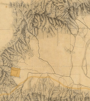
Early History with Native Americans
The land that is now West Hills was originally home to Native American tribes like the Tongva-Fernandeño and Chumash-Venturaño. They lived in the Simi Hills and near Bell Creek. Native American groups have lived in the San Fernando Valley for about 8,000 years.
A Chumash village called Hu'wam was located near Escorpión Peak (Castle Peak). This was a place where different tribes met and traded. There's a cave nearby, the Cave of Munits, which is part of a Chumash legend. Escorpión Peak is also important to the Chumash, as they believed it helped keep the natural world balanced.
Spanish and Mexican Times
From 1797 to 1846, the West Hills area was part of the Mission San Fernando Rey de España. After Mexico became independent from Spain, the land became part of a large ranch called Rancho Ex-Mission San Fernando. In 1845, a special land grant for Rancho El Escorpión was given to three Chumash people: Odón Eusebia, Urbano, and Mañuel. This ranch was west of what is now Woodlake Avenue in West Hills.
American History and Growth
Land Ownership Changes
When California joined the United States in 1850, the Spanish and Mexican land grants needed to be officially recognized by the U.S. government. The Rancho El Escorpión was officially given to the original Chumash owners in 1876. In 1912, the Chumash families sold the Rancho to George Platt, who started a dairy farm there. This area was not added to Los Angeles until 1958 and remained undeveloped until 1961.
Becoming West Hills: Separating from Canoga Park
West Hills was originally part of a community called Owensmouth, founded in 1912. Owensmouth was renamed Canoga Park in 1931.
In 1987, people living in a part of western Canoga Park wanted to create their own neighborhood called West Hills. They felt it would give their area a stronger identity and might even increase property values. This idea was supported by many residents but opposed by the Canoga Park Chamber of Commerce, who thought it would cause division.
Councilwoman Joy Picus supported the residents' request. She accepted petitions from many households and arranged for new boundary signs to be put up. This change meant that a significant part of what was once Canoga Park became West Hills.
Later, in 1994, the business leaders of Canoga Park and West Hills decided to work together and formed a combined Chamber of Commerce, which still exists today.
Parks and Famous Places
West Hills has several important historic ranches and a famous actor's estate that are recognized as Historic-Cultural Monuments. Many of these are now city parks, offering green spaces and fun activities.
Famous Landmarks
Orcutt Ranch Estate
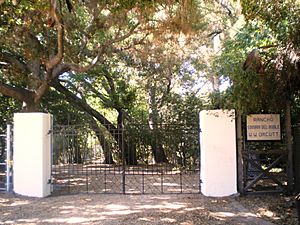
- Orcutt Ranch Estate was once the home and gardens of William Warren Orcutt, an early oil company executive. It has an adobe house, beautiful gardens, and citrus orchards from the 1920s. Today, it's a park where you can walk around, take house tours, pick citrus fruits during harvest, and even host special events like weddings. Orcutt Ranch is a protected Los Angeles Historic-Cultural Monument.
Shadow Ranch Park
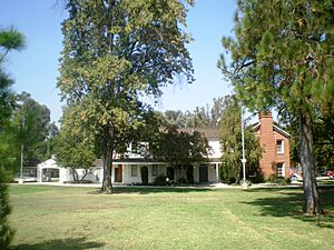
- Shadow Ranch Park is located on Vanowen Street. It was originally a wheat farm owned by Alfred Workman, who built a home there in the late 1800s. He also planted many eucalyptus trees, which some say are the source of all eucalyptus trees in California! Later, a screenwriting couple bought the ranch and renamed it Shadow Ranch because of all the shade from the trees. A movie called The Children’s Hour was filmed here in 1961. Today, Shadow Ranch Park is an L.A. City Park with basketball courts, a playground, sports fields, and picnic areas. It's also a protected Los Angeles Historic-Cultural Monument.
Open-Space Parks for Nature Lovers
These large parks are great for walking, hiking, mountain biking, and horseback riding. They are open from sunrise to sunset.
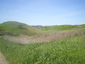
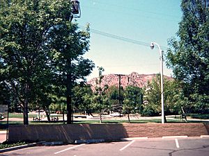
- El Escorpión Park: This park features the landmark El Escorpión Peak, which offers amazing views of the Valley after a hike. You can find the start of the trail and parking at the western end of Vanowen Boulevard.
- Bell Canyon Park: Located next to El Escorpión Park, this park has trails along the natural Bell Creek. You can access it from Bell Canyon Boulevard.
- Upper Las Virgenes Canyon Open Space Preserve: This huge natural park has trails that connect to other parks and open spaces, creating a large green area for West Hills. You can find parking and trailheads at the western end of Victory Boulevard. They also offer special events like moonlight hikes.
- Roscoe/Valley Circle Park: This is a long, open park with great views and a trail for horseback riding.
Neighborhood Parks for Fun and Play
- Knapp Ranch Park: This park has two sections. The east section offers baseball, basketball, a playground, picnic tables, and tennis courts. The west section is great for walks and has picnic areas with panoramic views.
- The West Hills Sports Center/Adam Bischoff Soccer Fields: This park has a recreation center and soccer fields.
- Mae Boyar Recreation Center: Here you'll find basketball courts and a playground.
- Taxco Trails Park: A small park with a playground and picnic tables.
- Lazy J Ranch: Another small park with a children's play area.
- Chase Park: This park has a children's play area and picnic tables.
- Hidden Lake Park: A neighborhood park located at Lees Lake.
- Castle Peak Park: A small park with a playground and picnic tables (not the same as El Escorpión Peak Park).
- Four Oaks Park: A small neighborhood park with a playground and picnic tables.
Other Historic Landmarks
Francis Lederer Estate
The Lederer Estate belonged to Francis Lederer (1899–2000), a stage and film actor. Two parts of his estate are protected Historic-Cultural Monuments: his former home and its gardens, and the equestrian stables. Francis Lederer was also an honorary Mayor of Canoga Park for many years.
- Francis Lederer Residence: This beautiful house, built starting in 1934, shows a mix of Mediterranean, Spanish Colonial, and Mission Revival styles. It sits on a hill with views of the Valley. The house uses stone from the area and has a large central courtyard. It was planned to become a public museum, but it is currently for sale.
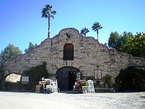
- Francis Lederer Stables: Built in 1936, these stables have a rustic Mission Revival style. They were originally next to Bell Creek. Today, the stables are used as an event venue called Hidden Chateau.
Peppergate Ranch
The Peppergate Ranch was a 29-acre property with a home designed by famous architect Paul R. Williams in 1939. This home, the T.R. Craig Residence, is also a Los Angeles Historic-Cultural Monument. The ranch was later divided into housing developments in the 1960s.
Hospitals in West Hills
The West Hills Hospital and Medical Center serves the local community and patients from nearby cities. It has a surgical center that opened in 1996, offering various types of surgeries. The hospital also has a large maternity ward and a unit for cancer treatment. In 2010, the Grossman Burn Centers, which treat burn injuries, moved to West Hills Hospital. The hospital does not have a trauma center, so serious emergency cases go to Northridge Hospital Medical Center.
Education in West Hills
Many adults in West Hills are highly educated. In 2000, about 38% of residents aged 25 and older had a four-year college degree, which is a high percentage for the city and county.
Schools in West Hills
The Los Angeles Unified School District runs the public schools in West Hills.
Public Elementary Schools
- Capistrano Avenue Elementary School
- Enadia Way Elementary School (Enadia Technology Enriched Charter School)
- Hamlin Street Elementary School (Hamlin Charter Academy)
- Haynes Elementary School
- Justice Street Elementary School
- Nevada Avenue Elementary School
- Pomelo Drive Elementary School
- Welby Way Elementary School
Private Schools
- de Toledo High School (formerly New Community Jewish High School)
- Chaminade College Preparatory (high school)
- Parkhill School
- Crane Academy of Excellence (K-12)
- Kadima Day School
- Hill Point Montessori Preparatory School
- Shepherd of the Valley Lutheran (preschool)
- West Valley Christian School
Nearby Public Middle and High Schools
These schools serve West Hills students but are located in neighboring areas:
- Hale Middle School—George Ellery Hale Charter Academy (Woodland Hills)
- Christopher Columbus Middle School (Canoga Park)
- Canoga Park Senior High School (Canoga Park)
- Chatsworth Senior High School—Chatsworth Charter High School (Chatsworth)
- El Camino Real Senior High School—El Camino Real Charter High School (Woodland Hills)
- Ivy Academia Entrepreneurial Charter School Tk-6 (Woodland Hills)
Other Community Features
West Hills has several religious buildings, including Our Lady of the Valley Catholic Church, Saint Bernardine Parish, and the Shomrei Torah Synagogue. Chabad of West Hills is also located nearby.
The Corporate Pointe business park is a large property in West Hills that is being planned for new development. It was originally built in 1959 for an aerospace company called Thompson-Ramo-Wooldridge (TRW Inc.). Later, other companies like Hughes Aircraft and Raytheon used it for aerospace and nuclear research.
Getting Around: Public Transportation
Public transportation in West Hills and the San Fernando Valley is provided by Metro Local bus routes, run by the Los Angeles County Metropolitan Transportation Authority (Metro). These buses connect to other public transport systems in nearby Woodland Hills, Canoga Park, and Chatsworth.
Some Metro Local bus routes that serve West Hills include: 162/163 (Sherman Way), 164 (Victory Boulevard), 165 (Vanowen Street), 169 (Saticoy Street), and 152/353 (Fallbrook Avenue and Roscoe Boulevard).
The G Line (Orange Line)
Metro Local buses connect to the G Line (also known as the Orange Line) at stations in Canoga Park, like Canoga station and Sherman Way station. The G Line goes southeast to the North Hollywood Metro Station, where you can transfer to the B Line subway to reach Downtown Los Angeles. The northbound G Line connects to the Chatsworth Transportation Center, which is a hub for Amtrak trains (Pacific Surfliner), Metrolink trains, and buses from other transit agencies.
Notable People from West Hills
- Blake Gailen (born 1985) – American-Israeli baseball player
- Miguel Leonis — 19th-century owner of Rancho El Escorpión
- Kevin Pillar — major league baseball outfielder
- Ramona Shelburne (born 1979) - sportswriter and softball player
|
See also
 In Spanish: West Hills para niños
 | Victor J. Glover |
 | Yvonne Cagle |
 | Jeanette Epps |
 | Bernard A. Harris Jr. |


