
Simi Hills facts for kids
Quick facts for kids Simi Hills |
|
|---|---|

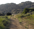
Sandstone rock formations of the Simi Hills range.
|
|
| Highest point | |
| Peak | Simi Peak |
| Elevation | 2,139 ft (652 m) |
| Geography | |

Location in California
|
|
| Country | United States |
| Range coordinates | 34°13′28.015″N 118°43′0.326″W / 34.22444861°N 118.71675722°W |
| Topo map | USGS Calabasas |
The Simi Hills are a group of low, rocky mountains in southern California, United States. They are part of the larger Transverse Ranges system. You can find them mostly in eastern Ventura County and western Los Angeles County. These hills are a special place for nature and history.
Contents
Exploring the Simi Hills Geography
The Simi Hills stretch out for about 26 miles (42 km) from east to west. They are about 7 miles (11 km) wide from north to south. Most of these hills are in southeastern Ventura County. Some parts, especially the lower hills, reach into western Los Angeles County.
The Simi Hills are located on the western edge of the San Fernando Valley. To the north, you'll find the Simi Valley. The Conejo Valley is to the southwest. Many cities are near or within the Simi Hills. These include Chatsworth, West Hills, and Woodland Hills in Los Angeles County. Also nearby are Agoura Hills and Westlake Village. In Ventura County, you'll find Thousand Oaks and Simi Valley city.
Two other mountain ranges are close by. The Santa Susana Mountains are to the northeast, across Santa Susana Pass. The Santa Monica Mountains run along the south.
Waterways of the Simi Hills
The Simi Hills are important for collecting water. They form the full or partial watersheds for many streams. Some streams flow all year, while others only flow during the rainy season.
These waterways include Las Virgenes Creek, Moore's Canyon Creek, Bell Creek, and Arroyo Simi. Bell Creek and Arroyo Calabasas are the starting points for the Los Angeles River. They join together in nearby Canoga Park.
Tallest Points in the Simi Hills
The highest points in the Simi Hills are called peaks. Some of the notable peaks include:
- Simi Peak, which is 2,403 feet (732 meters) high.
- Chatsworth Peak, standing at 2,314 feet (700 meters).
- Escorpión Peak (also known as Castle Peak), which is 1,475 feet (450 meters) tall.


Simi Hills Climate
The Simi Hills have mild, rainy winters because they are not very high up. It rarely snows here, even on the highest peaks. Summers are warm and dry, which means wildfires can happen.
Cool winds from the Pacific Ocean help keep the area cooler. These winds blow inland through the Santa Clara River Valley and the Conejo Valley. The Simi Hills block some of these winds, which affects the weather in the San Fernando Valley.
Plants and Animals of the Simi Hills
The Simi Hills are home to many different kinds of plants and animals. The natural areas here are very important for wildlife.
Plants of the Simi Hills
The lower hills to the south have mostly grasslands and oak savannas. A savanna is like a grassland with scattered trees. The rocky northern hills have mostly chaparral shrubland and oak woodlands. Chaparral is a type of plant community with dense shrubs.
The Simi Hills are part of the California chaparral and woodlands ecoregion. Many types of oak trees grow here, such as:
- The evergreen coastal live oak (Quercus agrifolia). Evergreen means it keeps its leaves all year.
- The deciduous valley oak (Quercus lobata). Deciduous means it loses its leaves in the fall.
- The scrub oak (Quercus dumosa).
Plants that grow near water, in riparian zones, include California sycamores (Platanus racemosa) and arroyo willows (Salix lasiolepis). In spring, you can see beautiful wildflowers like the redbush monkey flower (Mimulus aurantiacus) and Plummer's mariposa lily (Calochortus plummerae). Poison oak (Toxicodendron diversilobum) is also a common plant here.
Animals and Wildlife Corridors
The Simi Hills are a very important pathway for animals. They connect the Santa Monica Mountains near the coast to the Santa Susana Mountains, Topatopa Mountains, and San Gabriel Mountains further inland. This pathway is called a wildlife corridor. It allows large animals to move safely between different mountain ranges. This helps prevent animals from becoming isolated and keeps their populations healthy.
Many parts of the Simi Hills are protected as parks and open spaces. These protected areas help keep the wildlife corridor open.
Human History of the Simi Hills
People have lived in the Simi Hills for over 8,000 years. Early groups like the Paleo-indians and Chumash-Venturaño Native Americans used the area for homes and hunting.
The Chumash had a village called Hu'wam in Bell Canyon. It was a meeting place where Chumash, Tongva, and Tataviam peoples traded. This village was near Bell Creek and Escorpión Peak. Escorpión Peak was a very important spiritual place for the Chumash people. Nearby, you can find the Burro Flats Painted Cave, which has ancient rock art.
European Arrival and Land Grants
The first Europeans saw the Simi Hills in 1769 during the Juan Bautista de Anza expedition. Today, the Juan Bautista de Anza National Historic Trail passes through the southern part of the hills.
In 1845, a land grant called Rancho El Escorpión was given to Native Americans. This was rare at the time. Another large land grant, Rancho El Conejo, covered the western end of the Simi Hills.
Modern Development and Preservation
In the early 1900s, four large movie ranches were built in the Simi Hills. Movies were filmed there on location. Later, in the 1960s, more homes were built as Los Angeles grew. Some natural hillsides were changed to create flat areas for houses.
However, local citizens and groups like the Santa Monica Mountains Conservancy worked to protect large areas. They stopped big housing projects like Jordan Ranch and Ahmanson Ranch. These areas are now preserved as open space parks.
The Simi Hills were also home to the Rocketdyne Santa Susana Field Laboratory (SSFL). This site was used for testing rocket engines and for nuclear experiments. There were some accidents at the site, including a serious one in 1959. This event released more radiation than the Three Mile Island accident 20 years later. Because of this, the groundwater in some areas became contaminated. Now, there are plans to clean up the site and turn it into public parkland. This will help protect more open space in the Simi Hills.
Parks and Open Spaces in the Simi Hills
The Simi Hills offer many parks and open spaces for people to enjoy nature.
- Bell Canyon Park with Bell Creek; located in West Hills and Bell Canyon.
- Challenger Park
- Cheeseboro/Palo Comado Canyon Park - part of the Santa Monica Mountains National Recreation Area, in the western Simi Hills.
- El Escorpión Park and the Moore's Canyon Juan Bautista de Anza National Historic Trail segment; located in West Hills, Los Angeles.
- Rocky Peak Park - next to and above Santa Susana Pass.
- Ronald Reagan Presidential Library complex with museum.
- Sage Ranch Park - near the Santa Susana Field Laboratory, with trails and camping.
- Santa Susana Pass State Historic Park - features the Old Santa Susana Stage Road in the rocky northern Simi Hills.
- Upper Las Virgenes Canyon Open Space Preserve - (formerly Ahmanson Ranch Park), a large 3,000-acre (12 km²) park managed by the Santa Monica Mountains Conservancy.
Nearby Mountain Ranges
The Simi Hills are part of a larger system of mountains. Other ranges nearby include:
Images for kids
-
Sandstone rock formations of the Simi Hills range.
-
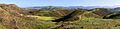
View of Simi Hills looking south from Oakbrook Regional Park, with the Santa Monica Mountains in the distance
-
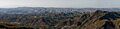
Panoramic view of the Simi Hills looking north from the Santa Monica Mountains
