
Santa Monica Mountains National Recreation Area facts for kids
Quick facts for kids Santa Monica Mountains National Recreation Area |
|
|---|---|
|
IUCN Category V (Protected Landscape/Seascape)
|
|

Backbone Trail near Mishe Mokwa
|
|

Santa Monica Mountains National Recreation Area
Location in California

Santa Monica Mountains National Recreation Area
Location in the United States
|
|
| Location | Santa Monica Mountains; Los Angeles and Ventura Counties, California, U.S. |
| Nearest city | Malibu, California Newbury Park, California |
| Area | 156,671 acres (634.03 km2) |
| Established | November 10, 1978 |
| Visitors | 609,636 (in 2011) |
| Governing body | National Park Service; with State and local agencies. |
| Website | Santa Monica Mountains National Recreation Area |

The Santa Monica Mountains National Recreation Area is a huge outdoor playground in Southern California. It's a special place with many parks and open areas, mostly found in the Santa Monica Mountains. This recreation area stretches across Los Angeles and Ventura counties.
The National Park Service helps manage this area, working with state and local groups. The Santa Monica Mountains National Recreation Area protects a great example of a Mediterranean climate ecosystem. This means it has mild, wet winters and hot, dry summers. It also has many important archaeological sites, showing where people lived long ago.
This recreation area is the largest urban national park in the United States. It is also the largest urban national park in the world.
In November 2018, the Woolsey Fire burned a lot of the land here. About 83% of the National Park Service land in the area was affected.
Contents
- Exploring the Santa Monica Mountains
- A Look Back: History of the Park
- Griffith Park: The First Protected Area
- Early Efforts for a National Forest
- Whitestone National Park Idea
- Frederick Law Olmsted, Jr.'s Vision
- Will Rogers State Historic Park is Created
- Toyon National Park Campaign
- Point Mugu State Park: A Big Step
- Topanga State Park Opens
- Malibu Creek State Park: From Movies to Nature
- The National Recreation Area is Born
- More Land is Added
- Rim of the Valley Trail Study
- The Woolsey Fire's Impact
- Park Leaders
- Cultural Treasures and Ancient History
- Fun Things to Do and See
- Parks Within the Recreation Area
- Images for kids
Exploring the Santa Monica Mountains

The Santa Monica Mountains National Recreation Area covers about 156,671 acres. This land is located in the Santa Monica Mountains between the Pacific Ocean and inland valleys. Some of its eastern slopes are where the Los Angeles River begins.
The California State Park system owns 42,000 acres. The National Park Service controls 23,620 acres. The rest of the land belongs to local parks, university study areas, and private lands protected for nature.
A Look Back: History of the Park

People have worked to protect the Santa Monica Mountains for a long time. This effort led to the creation of the Santa Monica Mountains National Recreation Area in 1978.
Before modern times, Native American tribes like the Chumash and Tongva lived here for thousands of years. Later, Spanish explorers, ranchers, and homesteaders came to the area. They brought new ideas and ways of life that shaped the land. Today, people still live, work, and enjoy the Santa Monica Mountains.
Places like Paramount Ranch, Solstice Canyon, and Rancho Sierra Vista/Satwiwa still show this long history. We learn about the past through old photos, letters, and even things people threw away. The Santa Monica Mountains National Recreation Area works hard to save these stories and places for the future.
Griffith Park: The First Protected Area
The first part of the Santa Monica Mountains set aside for public use was Griffith Park. Griffith J. Griffith gave this land to the city of Los Angeles in 1896.
Early Efforts for a National Forest
In the early 1900s, Frederick H. Rindge tried to create a forest reserve in the Santa Monica Mountains. These reserves were like early versions of national forests. However, these plans were often stopped due to local opposition. People worried about how it would affect their land.
Whitestone National Park Idea
In 1925, limestone was found in the mountains near Pacific Palisades. This led to a big fight between wealthy homeowners and land developers. A local resident, Sylvia Morrison, wanted to protect the area's natural beauty.
She suggested creating "Whitestone National Park," named after the white limestone cliffs. This idea was inspired by places like Yellowstone National Park.
Frederick Law Olmsted, Jr.'s Vision
In 1930, Frederick Law Olmsted, Jr. suggested a network of parks, beaches, and forests for Los Angeles. He wanted the public to own at least 10,000 acres of the most beautiful beach and mountain areas. However, his ideas were mostly ignored by city leaders at the time.
Will Rogers State Historic Park is Created
Will Rogers State Historic Park was created in 1944. This was the first state park in the Santa Monica Mountains. It was also the first public land created in the mountains since Griffith Park in 1896.
Toyon National Park Campaign
In the 1960s and 70s, there was another big effort to protect the Santa Monica Mountains. Several plans were sent to the U.S. Congress to create "Toyon National Park." Toyon is a common plant found in the area.
Point Mugu State Park: A Big Step
Point Mugu State Park was established in 1967. It was one of the first large state parks in the Santa Monica Mountains. More land was added later, making it even bigger. Part of this land later became Rancho Sierra Vista open space park.
Topanga State Park Opens
Topanga State Park opened to the public in 1974. This park is very large, covering 11,525 acres. It stretches from the Pacific Coast Highway to Mulholland Drive.
Malibu Creek State Park: From Movies to Nature
Malibu Creek State Park is in the heart of the Santa Monica Mountains. This area was once a movie ranch called 20th Century Fox Movie Ranch. The State of California bought it in 1974 to create the park. Even land once owned by Ronald Reagan and Bob Hope became part of this park.
The National Recreation Area is Born
The Santa Monica Mountains National Recreation Area was officially created on November 10, 1978. This happened after a long effort by people who wanted to protect the mountains. Susan B. Nelson was a key person in this movement.
The plan was to grow the recreation area bit by bit, connecting important wildlife areas and adding to existing parks. The Santa Monica Mountains Conservancy, a California state agency, was formed in 1980. Its job is to buy land for preservation and public recreation.
More Land is Added
In 1980, the Paramount Movie Ranch was acquired. Today, it is the Paramount Ranch Park. It's still used for movies and TV shows, and people can visit for fun.
Entertainer Bob Hope was involved in a plan in the early 1990s to swap land. He wanted to sell a large area in Corral Canyon to the government. In return, he wanted a smaller piece of federal parkland to build a golf course. This land swap never happened. Most of the land for Corral Canyon Park was later donated by Bob Hope.
In 2003, the former Ahmanson Ranch was acquired. This created the 2,983-acre Upper Las Virgenes Canyon Open Space Preserve. This area is great for hiking and exploring.
Other important lands have been protected too. These include hills near the junction of U.S. Route 101 and Las Virgenes Road. These areas keep beautiful open spaces for everyone to enjoy.
Rim of the Valley Trail Study
The National Park Service is studying a plan called the "Rim of the Valley Corridor." This plan aims to connect the mountains around the San Fernando, La Crescenta, Santa Clarita, Simi, and Conejo Valleys. The Santa Monica Mountains National Recreation Area is part of this big plan.
The Woolsey Fire's Impact
In 2018, the Woolsey Fire burned through 88% of the federal parkland. This fire was much larger than any before it in the mountains. It burned over 40% of the natural area. After the fire, plants like black mustard grew quickly. These plants can provide fuel for future fires.
Park Leaders
Here are the people who have led the park over the years:
- Robert Chandler, 1979–1982
- Daniel Kuehn, 1983–1988
- William Webb (Acting Superintendent), 1988–1989
- David Gackenbach, 1989–1995
- Arthur Eck, 1995–2002
- Woody Smeck, 2002–2012
- David Szymanski, 2012–present
Cultural Treasures and Ancient History
The Santa Monica Mountains have a very long history of human life. People have lived here for more than 10,000 years. There are many important ancient and historical sites.
More than 1,000 archaeological sites are within the Santa Monica Mountains National Recreation Area. This means it has one of the highest numbers of ancient sites in any mountain range in the world. There are also twenty-six known Chumash pictograph sites. These are sacred to Native American Indians and are considered unique and important world heritage.
The park shows nearly every major part of human history in the western United States. This includes early hunters, Native American cultures, the Spanish mission period, and the American homestead era.
Many sites in the Santa Monica Mountains could be listed on the National Register of Historic Places. The Santa Monica Looff Hippodrome on the famous Santa Monica Pier is a National Historic Landmark. So is Will Rogers' house at Will Rogers State Historic Park. The ancient drawings at the Saddle Rock Ranch Pictographs are also very important. They might show the Portolá expedition from 1769–1770.
Several California Historical Landmarks are also in the area. These include the Site of the Port of Los Angeles Long Wharf (no. 881), Point Dume (no. 965), and the Adamson House of Malibu Lagoon State Beach (no. 966).
Fun Things to Do and See


The Anthony C. Beilenson Interagency Visitor Center at King Gillette Ranch opened in June 2012. It's a great place to start your visit. You can find it at 26876 Mulholland Highway, Calabasas, CA, 91302.
The Satwiwa Native American Indian Culture Center is a special place. It focuses on the past, present, and future of all Indian cultures. You can talk to a Native American guest-host or a park ranger on weekends. They also have workshops and art shows throughout the year. Satwiwa means "bluff" in the Chumash language. It refers to the cliffs of Boney Peak that you can see from there. The center is at Rancho Sierra Vista in Newbury Park.
The main office for the park is at 401 West Hillcrest Drive, Thousand Oaks 91360.
There are tons of fun things to do here! You can go biking, birdwatching, or even watch gray whales from the land. You can also go camping, hiking, horseback riding, and rock climbing. The Backbone Trail is nearly 70 miles long. It runs across the Santa Monica Mountains between Will Rogers State Park and Point Mugu State Park. Channel Islands National Park is also nearby in the Pacific Ocean.
Park Partners
Many groups work together to support the Santa Monica Mountains National Recreation Area. These include city, county, and state agencies, as well as other organizations. Some of these partners are:
- Allied Artists Santa Monica Mountains
- Cold Creek Docents
- City of Malibu Parks & Recreation Dept
- The Children’s Nature Institute
- California Native Plant Society
- Concerned Off-Road Bicyclists Association
- Conejo Recreation & Park District
- Coastwalk California
- Friends of Runyon Canyon
- Los Angeles County Recreation & Parks Dept
- L.A. Chapter of the North American Butterfly Association
- Los Angeles Audubon Society
- Malibu Creek Docents
- Malibu Lagoon Museum Docents
- Mountains Recreation & Conservation Authority
- Mountains Restoration Trust
- Nature Bridge
- The Nature of Wildworks
- Resource Conservation District of the Santa Monica Mtns
- Sierra Club
- San Fernando Valley Audubon Society
- San Fernando Valley Gourd Patch
- Santa Monica Bay Audubon Society
- Santa Monica Mountains Conservancy
- Santa Monica Mountains Fund
- Santa Monica Mountains Natural History Association
- Santa Monica Mountains Trails Council
- Stunt Ranch Santa Monica Mountains Reserve
- Temescal Canyon Association
- Topanga Canyon Docents
- Thousand Oaks Plein Air Watercolorists
- TreePeople
- Will Rogers State Historic Park Docents
Park Entrances
You can enter the Santa Monica Mountains National Recreation Area from several cities. These include Malibu, Newbury Park, Agoura Hills, Calabasas, Woodland Hills, and Topanga, California.
Vehicle Rules
- Only electric or non-motorized model aircraft are allowed.
- Only electric or non-motorized model land vehicles are allowed.
- No motorized model boats are allowed on park waters.
- Electric and non-motorized models have been used at the Paramount Ranch area for a long time.
Parks Within the Recreation Area
The National Park Service manages these parks and areas in the Santa Monica Mountains National Recreation Area:
- Arroyo Sequit
- Backbone Trail System
- Diamond X Ranch
- Paramount Ranch
- Peter Strauss Ranch
- Rancho Sierra Vista
- Rocky Oaks
- Zuma and Trancas Canyons
The following California State Parks are also part of the Santa Monica Mountains National Recreation Area:
- Topanga State Park
- Leo Carrillo State Park
- Malibu Creek State Park
- Point Mugu State Park
- Will Rogers State Historic Park
These State Beaches are in or next to the Santa Monica Mountains National Recreation Area:
Images for kids
-
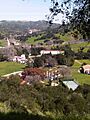
King Gillette Ranch Park
-
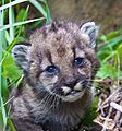
Mountain lion kitten P-54, born in early 2017 in the SMMNRA


