Backbone Trail facts for kids
Quick facts for kids Backbone Trail |
|
|---|---|

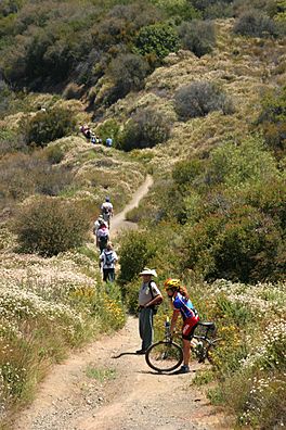
The Backbone Trail between Will Rogers State Historic Park and Trippet Ranch in Topanga State Park
|
|
| Length | 67.79 mi (109.10 km) |
| Location | Los Angeles County / Ventura County, California, USA |
| Designation | National Recreation Trail |
| Trailheads | Point Mugu State Park / Will Rogers State Historic Park |
| Use | Hiking, Cycling, Horseback Riding |
| Highest point | Sandstone Peak |
| Lowest point | Pacific Ocean |
| Difficulty | Moderate to Strenuous |
| Season | Year-round |
| Sights | Santa Monica Mountains |
| Hazards | Heat Stroke Mountain lions Poison oak Lyme disease Venomous snakes |
The Backbone Trail is a very long path, stretching 67.79 miles (109.10 km) across the Santa Monica Mountains in California. It starts at Point Mugu State Park and finishes at Will Rogers State Historic Park in Pacific Palisades. Hikers can use the entire trail. Parts of the trail also allow mountain bicyclists, horseback riders, and dogs.
Contents
History of the Backbone Trail
Construction on the Backbone Trail began in the early 1980s. Many groups worked together to create it. These included the National Park Service and the California Department of Parks and Recreation. Private groups also helped connect existing paths. This created one long trail across the Santa Monica Mountains National Recreation Area.
The trail has different types of paths. Some parts are wide, flat roads. Other parts are narrow, single-track trails. This is because the trail was made by joining many smaller paths.
In 2016, the National Park Service bought more land. This helped complete the trail. Former California Governor Arnold Schwarzenegger and Betty Weider helped with these land deals. A new section of the trail opened in May 2016.
When it fully opened in 2016, the Backbone Trail received a special title. It was named a National Recreation Trail. This means it is an important trail for everyone to enjoy.
The official opening ceremony was on June 4, 2016. It took place at Will Rogers State Park. A ribbon-cutting ceremony marked the big day. Later, in 2018, parts of the trail closed. This happened after the Woolsey Fire. This fast-moving fire burned a lot of land. About 88% of the federal parkland in the Santa Monica Mountains was affected. The Backbone Trail fully reopened in July 2019.
Exploring the Trail's Landscape
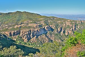
The Backbone Trail goes over peaks and through canyons. This means the trail often changes height. It climbs up and goes down a lot. The lowest point is at sea level. This is the Ray Miller Trailhead at Point Mugu State Park. The highest point is Sandstone Peak. This peak is 3,111 feet (948 m) high. It is the tallest peak in the Santa Monica Mountains.
You can see amazing views of Ventura County. A six-mile loop trail starts near Yerba Buena Road. The Mishe Mokwa Trail follows Carlisle Canyon. It goes past Boney Mountain and red volcanic rocks. You can also see cool caves and cracks at Echo Cliffs. There is a picnic area by a huge split rock called Split Rock.
The return path on the Backbone Trail leads to Inspiration Point. It then goes up to Sandstone Peak. Both these spots offer views of the Pacific Ocean. You can also see the Channel Islands and nearby mountains.
Parts of the trail are inside Los Angeles and Malibu, California. Other parts are in areas of Los Angeles County and Ventura County. The Backbone Trail passes through several important natural areas. These include:
- Will Rogers State Historic Park
- Santa Monica Mountains National Recreation Area
- Topanga State Park
- Cold Creek Canyon Preserve
- Malibu Creek State Park
- Zuma and Trancas Canyons
- Point Mugu State Park
Plants and Animals
The Backbone Trail is in the California chaparral and woodlands area. This means you can see many different plants and animals.
Plants on the Trail
Most of the Backbone Trail goes through areas with low bushes and shrubs. These plants are typical of the coastal sage scrub and chaparral ecosystems. There are not many trees along the trail. This means there is often not much shade for hikers.
Animals on the Trail
More than 450 types of animals live in the Santa Monica Mountains. This includes over 380 kinds of birds. Lizards are very common. You can often see them on or near the trail.
In early spring, you might see Southern Pacific rattlesnakes. They are more common along Temescal Ridge. Mountain lions have also been seen in the western part of the trail. About eight mountain lions are thought to live in the area.
Some interesting animals you might see along the Backbone Trail are:
- Bobcat
- California Kingsnake
- Coyote
- Mountain lion
- Pacific treefrog
- Peregrine falcon
- Red-tailed hawk
- Southern Pacific rattlesnake
Hiking the Backbone Trail
The Backbone Trail is a well-kept path. Most of it is a single-track trail. Some parts are dirt roads. The trail is designed well, with gentle climbs and descents. These parts have many switchbacks (zig-zag turns).
You can hike the trail from west to east, or east to west. There are no big differences between the two directions. If you hike west, you will go towards more remote areas. You can end your hike at the Pacific Ocean. However, getting a ride from the Ray Miller Trailhead might be harder. You do not need a special permit to hike the Backbone Trail.
Camping along the Backbone Trail is only allowed at special campgrounds. Some campsites can be booked ahead of time. Others are available first-come, first-served. There are not many campgrounds right on the trail. They are also not spread out evenly. This can make it tricky to plan a long hike. If you want to hike the whole trail, you might need to find places to stay off the trail. There are other lodging options nearby.
Images for kids
 | Isaac Myers |
 | D. Hamilton Jackson |
 | A. Philip Randolph |


