
Santa Clara River Valley facts for kids


The Santa Clara River Valley is a beautiful area in Ventura County, California. It's mostly made up of farms and open land. People sometimes call it the Heritage Valley because a group that promotes tourism gave it that name. In this valley, you'll find towns like Santa Paula, Fillmore, and Piru. It's also home to Rancho Camulos, which is a very important historical place. The valley gets its name from the Santa Clara River, which flows through it and eventually reaches the Pacific Ocean near the cities of Ventura and Oxnard. Many people describe it as one of Southern California's last natural farming valleys, right next to the free-flowing river.
Contents
Exploring the Valley's Geography
The Santa Clara River Valley is surrounded by mountains. To the north, you'll find the Topatopa Mountains, Los Padres National Forest, and the Sespe Condor Sanctuary. To the south, there are the Santa Susana Mountains. The valley stretches a long way, from the edge of Los Angeles County in the east to the Oxnard Plain in the west. The Santa Clarita Valley is also part of the larger area where the river begins.
Winds and Wildfires in the Valley
This valley is known for being a place where strong winds can cause problems, especially with wildfires. It acts like a "wind tunnel" that funnels strong winds called Santa Ana winds from the desert towards the coast. These winds can make wildfires spread very quickly. The valley has experienced several big fires, including the Maria Fire in 2019, the Saddleridge Fire also in 2019, the Creek Fire and the Thomas Fire in 2017, and the Sayre Fire in 2008.
A Look Back at the Valley's History
Long ago, in the 1700s, Spanish missionaries used a simple path through this valley. It was the only way to travel between the San Fernando and San Buenaventura missions. Later, in the 1870s, a man named Thomas Bard worked hard to build a road through the valley. He wanted to connect the new Hueneme wharf to important ore mines in Inyo County.
The Santa Clara River Valley is special because it has kept its many citrus farms. After World War II, most of Southern California saw its citrus groves disappear as cities grew. But this valley managed to keep its agricultural heritage.
The Great Flood of 1928
One of the most significant events in the valley's history was the failure of the St. Francis Dam. This happened in the middle of the night on March 12, 1928. The dam broke, releasing a massive amount of water – about 12.4 billion gallons (47 billion liters)! This huge wave of water rushed down San Francisquito Canyon and then flowed into the Santa Clara River, moving all the way down the valley to the ocean.
Getting Around: Transportation in the Valley
- Route 126: This is the main highway that runs east to west through the valley.
- Route 150: This is a smaller east-west highway that connects the town of Ojai to the valley.
- Route 23: This is a smaller north-south highway that links Fillmore to the Conejo Valley.
Images for kids
-
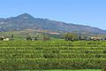
Orange groves, where citrus fruits like oranges grow, in the Santa Clara River Valley.

