
Piru, California facts for kids
Quick facts for kids
Piru, California
|
|
|---|---|

Location in Ventura County and the state of California
|
|

Piru, California
Location in California
|
|
| Country | United States |
| State | California |
| County | Ventura |
| Town established | 1887 |
| Area | |
| • Total | 2.836 sq mi (7.343 km2) |
| • Land | 2.820 sq mi (7.303 km2) |
| • Water | 0.016 sq mi (0.040 km2) 0.55% |
| Elevation | 709 ft (216 m) |
| Population
(2020)
|
|
| • Total | 2,587 |
| • Density | 912.2/sq mi (352.31/km2) |
| Time zone | UTC-8 (Pacific) |
| • Summer (DST) | UTC-7 (PDT) |
| ZIP code |
93040
|
| Area code | 805 |
| FIPS code | 06-57372 |
| GNIS feature IDs | 1652775, 2409077 |
.jpg)
Piru (pronounced Pie-roo) is a small, historic town in eastern Ventura County, California. It is located in the Santa Clara River Valley, close to the Santa Clara River and Highway 126. Piru is about 7 miles (11 km) east of Fillmore. Lake Piru, found in the Los Padres National Forest, is a popular spot for outdoor fun. In 2020, about 2,587 people lived in Piru.
Contents
What Does the Name Piru Mean?
The name Piru comes from the Chumash word pí idhu-ku. This word described the tule reeds that grew along Piru Creek. These reeds were important for making baskets. The name was originally pronounced "Pea-roo." In 1888, the town was first called Piru City.
Piru's Past: A Look at Its History


Who Lived Here First? The Tataviam People
The Tataviam were the first people to live in this area. They often built their villages near water sources like Piru Creek and the Santa Clara River. The Tataviam village of Piiru was the original settlement here. There was also a village called Kamulus nearby, shared by the Tataviam and Chumash.
Piru Creek was a place where the Chumash and Tataviam shared the land. Important foods for the Tataviam included yucca plants, acorns, and berries. They would collect yucca hearts in the spring and cook them in earth ovens.
How Piru Was Founded and Grew
The town of Piru was started in 1887 by David C. Cook. He was a rich publisher from Illinois. Cook bought the Rancho Temescal land grant. He wanted to create a "Second Garden of Eden" here. He planned for the land to be planted with fruits like apricots, figs, and grapes.
In 1887, the coast rail line was built through the valley. Cook built his own train depot in Piru. He laid out the town around the railroad in 1888. The U.S. Post Office opened in Piru on June 14, 1888.
Cook built a large home, the Piru Mansion, in 1890. He also helped build a church. His first home became the Piru Hotel. Cook sold his land in 1900 after oil was discovered nearby.
The novel Ramona (1884) used nearby Rancho Camulos as a setting. Parts of the 1910 silent movie of the same name, starring Mary Pickford, were filmed there. The actors and crew stayed at the Piru Hotel. This hotel later became the Mountain View Hotel, and then the Round Rock Hotel.
Piru in the 1900s
Juan José Fustero, known as "the last full-blooded Piru Indian," passed away in 1921. A plaque was placed in Piru Canyon in 1961 to honor him.
In the 1950s, the Round Rock Hotel became a rest home for older people. Its classic style made it popular for movies. It was used in films like The Five Heartbeats (1991). Later, it became the Heritage Valley Inn, but it is no longer an inn.
Major Events in Piru's History
Piru faced two big challenges in the 20th century.
- On March 12, 1928, the St. Francis Dam broke. This sent a huge flood through the Santa Clara River Valley. Many people, including some in Piru, lost their lives.
- The Northridge earthquake on January 17, 1994, damaged several buildings in the historic downtown area.
Piru's Location and Environment
Piru is located at 34°24′26″N 118°47′59″W / 34.40722°N 118.79972°W. The area covers about 2.8 square miles (7.3 square kilometers). Most of this area is land, with a small amount of water. Piru is about 692 feet (211 meters) above sea level. It sits in the Santa Clara River Valley.
What is Piru's Climate Like?
Piru has hot and dry summers. This type of weather is called a hot-summer Mediterranean climate.
Piru's Economy: How People Make a Living
Piru has many people who work in farming and manufacturing. About 32% of workers are in manufacturing. Another 28% work in agriculture. In 1999, Piru had the lowest average home prices in Ventura County.
Piru's Population: Who Lives Here?
Population in 2020
The 2020 United States Census reported that Piru had a population of 2,587 people.
Population in 2010
In 2010, Piru had 2,063 residents. About 84.7% of the people were of Hispanic or Latino background. The population included people from various racial groups. The average age was 29.4 years. About 32.8% of the population was under 18 years old.
Piru's Services and Schools
.jpg)
Ventura County Waterworks District No. 16 provides water and sewer services to Piru. The Fillmore Unified School District runs Piru Elementary School. Older students attend Fillmore Middle School and Fillmore High School in Fillmore.
Piru on Screen: A Popular Filming Location
Piru has been a popular spot for movies and TV shows for many years. Its historic buildings and natural scenery make it a great place to film.
- Desert Fury (1947) used Piru for scenes, including the Piru Mansion.
- A Star Is Born (1954), with Judy Garland, filmed scenes here.
- The 1974 TV movie The California Kid used Piru as the fictional town of Clarksberg.
- Many TV shows have filmed in Piru, such as The A-Team, The Dukes of Hazzard, Murder, She Wrote, and NCIS.
- The horror film Dark Night of the Scarecrow (1981) used Piru's café, post office, and service station.
- Twilight Zone: The Movie (1983) filmed scenes at the historic building now known as the Heritage Valley Inn.
- Dolly Parton and Sylvester Stallone filmed parts of Rhinestone (1984) in Piru.
- The town was used as the countryside in the movie Cobra, starring Sylvester Stallone.
- The comedy Happy, Texas (1999) was almost entirely filmed in Piru.
- The exterior of Piru United Methodist Church was seen in Big Momma's House (2001).
- Action scenes from movies like Enough (2002) and Torque (2004) were filmed here.
- The movie The Amateurs (2005) and parts of True Blood were also filmed in Piru.
- In the Disney movie Race to Witch Mountain (2009), Piru stood in for the small town of Stony Creek.
- Piru Mansion was used in Atlas Shrugged: Part I (2011).
- The music video for "Don't Stop (Color on the Walls)" by Foster the People (2011) was filmed here.
- The TV show Dexter filmed an episode in Piru in 2011.
- The music video for "Wake Me Up" by Avicii (2013) was filmed in Piru.
- Water for Elephants and Alicia Keys' "Unthinkable" music video were also filmed here.
- The action-drama film Swelter (2014) was filmed entirely in Piru.
- The movie Lucky (2017), starring Harry Dean Stanton, was filmed in Piru.
Images for kids
-
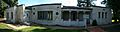
The Rancho Camulos ranch foreman’s house in Piru, before its renovation as a visitor center.
-
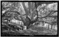
A very large black walnut tree at the historic Rancho Camulos, Piru, 1934
See also
 In Spanish: Piru (California) para niños
