
Santa Paula, California facts for kids
Quick facts for kids
Santa Paula, California
|
|||
|---|---|---|---|
 .jpg) _(cropped).jpg) Top: Thomas Aquinas College; Bottom: historic train depot (left) and downtown (right)
|
|||
|
|||
| Nickname(s):
Citrus Capital of the World
|
|||

Location in Ventura County and the state of California
|
|||

Santa Paula, California
Location in the United States
|
|||
| Country | United States | ||
| State | California | ||
| County | Ventura | ||
| Founded | 1872 | ||
| Incorporated | April 22, 1902 | ||
| Area | |||
| • City | 5.69 sq mi (14.75 km2) | ||
| • Land | 5.53 sq mi (14.32 km2) | ||
| • Water | 0.16 sq mi (0.42 km2) 2.41% | ||
| Elevation | 279 ft (85 m) | ||
| Population
(2020)
|
|||
| • City | 30,657 | ||
| • Density | 5,543.76/sq mi (2,081.00/km2) | ||
| • Metro | 823,318 | ||
| Time zone | UTC−8 (Pacific) | ||
| • Summer (DST) | UTC−7 (PDT) | ||
| ZIP Codes |
93060, 93061
|
||
| Area code | 805 | ||
| FIPS code | 06-70042 | ||
| GNIS feature IDs | 1652793, 2411826 | ||


.jpg)
.jpg)
Santa Paula is a city in Ventura County, California, United States. Its name comes from the Catholic Saint Paula. The city is surrounded by fruit orchards in the Santa Clara River Valley. Santa Paula is known as the "Citrus Capital of the World" because of its many citrus farms.
Santa Paula was also an important place for California's early oil industry. The Union Oil Company Building, which was the first headquarters for the Union Oil Company of California in 1890, is now the California Oil Museum. In 2020, about 30,657 people lived in Santa Paula.
Contents
History of Santa Paula
Early Beginnings and Native People
Before Europeans arrived, the area where Santa Paula is now was home to the Chumash people. They were a Native American group.
In 1769, Spanish explorers led by the Portola expedition traveled through California. They came down the Santa Clara River Valley and camped near Santa Paula on August 12. A missionary named Fray Juan Crespi was with them. He named the valley Cañada de Santa Clara. He also noted a large native village nearby, which he called San Pedro Amoliano. This spot is now a California Historical Landmark.
Founding the City and Early Growth
Franciscan missionaries, led by Father Junipero Serra, later came to the area. They set up a mission outpost. The town's name, Santa Paula, comes from a Catholic saint. The city is located on land that was part of a Mexican land grant called Rancho Santa Paula y Saticoy in 1843.
In 1872, Nathan Weston Blanchard bought a large area of land. He is seen as the founder of Santa Paula. He started planting orange trees in 1874.
Several small oil companies joined together to form the Union Oil Company in 1890. This made Santa Paula an important center for the oil industry.
Santa Paula officially became a city in April 1902. Lewis Arthur Hardison was the first mayor.

In 1911, a film company called Star Film Company moved to Santa Paula. They filmed many movies there.
Oil Industry and Modern Expansion
The large South Mountain Oil Field was found near Santa Paula in 1916. This oil field helped the city grow even more. Even today, oil is still extracted from this area.
Starting in 2016, a big project began to build 1,500 new homes in Santa Paula. This expansion is helping the city grow.
Major Events and Challenges
Santa Paula has faced challenges like floods and wildfires.
Historic Floods
The Great Flood of 1862
The Great Flood of 1862 was a huge flood that started in December 1861. It rained for almost four weeks, causing widespread flooding across California.
St. Francis Dam Collapse
On March 12, 1928, the St. Francis Dam collapsed in the middle of the night. A massive amount of water, about 12.4 billion gallons, rushed down the canyon and into the Santa Clara River. The flood reached Santa Paula around 3:00 a.m.
Many homes and buildings were destroyed. However, many lives were saved because two motorcycle police officers rode through the town, warning people to get to safety. A sculpture in downtown Santa Paula called "The Watchers" honors their brave actions.
Wildfires Affecting Santa Paula
Thomas Fire
In December 2017, the Thomas Fire started near Santa Paula. Strong winds pushed the fire away from the city towards Ventura and Santa Barbara. It became one of the largest wildfires in California's modern history.
The fire burned over 281,000 acres (about 440 square miles). While it destroyed many structures in other areas, only a few small buildings just outside Santa Paula were affected. The fire was fully contained in January 2018.
Maria Fire
On October 31, 2019, the Maria Fire started on South Mountain, between Santa Paula and Somis. Strong winds quickly made the fire grow very large. It grew from 50 acres to over 4,000 acres in just a few hours.
The fire moved towards Santa Paula. Many people had to leave their homes for safety. Over 1,800 homes were evacuated, affecting more than 7,500 people.
Industrial Incident at a Wastewater Plant
On November 18, 2014, an incident occurred at the Santa Clara Waste Water plant. A truck exploded, causing a spill of a chemical mixture. Two workers were hurt in the explosion.
Later, three firefighters were injured by fumes from the spill, and about 50 other people needed medical attention. The spilled liquid could catch fire easily as it dried. It also reacted to touch or pressure. When the first fire truck drove over it, and firefighters walked on it, small explosions happened.
The incident became more serious when other materials started to burn and explode. This created a large cloud of smoke that spread for about 3 miles. Nearby residents and businesses had to evacuate. Highway 126 was also closed.
What Caused the Incident
Investigators found that a chemical mixture, possibly an organic peroxide, was involved. It was believed that a worker might have accidentally mixed this chemical with wastewater in the truck. This mixture then caused the explosion.
Aftermath of the Incident
The incident caused injuries, especially to the lungs of three firefighters. The area around the plant needed a lot of cleaning. The U.S. Environmental Protection Agency helped oversee the cleanup. The chemicals were made safe and taken to a landfill.
Geography and Climate
Where is Santa Paula Located?
The city of Santa Paula covers about 4.7 square miles. It is located in the Santa Clara River Valley, on the north side of the Santa Clara River. The city is surrounded by many fruit orchards.
The downtown area is focused around Main Street. This area has some of the oldest homes in the city. These homes are often bungalows, cottages, Victorian-style houses, and craftsman homes.
Santa Paula's Weather
Santa Paula has a warm-summer mediterranean climate. This means it has warm summers and cool winters. This type of climate is common in coastal Southern California.
| Climate data for Santa Paula, California, 1981–2010 normals, extremes 1894–2008 | |||||||||||||
|---|---|---|---|---|---|---|---|---|---|---|---|---|---|
| Month | Jan | Feb | Mar | Apr | May | Jun | Jul | Aug | Sep | Oct | Nov | Dec | Year |
| Record high °F (°C) | 97 (36) |
92 (33) |
98 (37) |
105 (41) |
106 (41) |
108 (42) |
105 (41) |
105 (41) |
110 (43) |
108 (42) |
99 (37) |
99 (37) |
110 (43) |
| Mean daily maximum °F (°C) | 69.3 (20.7) |
69.2 (20.7) |
71 (22) |
74 (23) |
75.1 (23.9) |
77.2 (25.1) |
80.7 (27.1) |
82.7 (28.2) |
81.6 (27.6) |
78.5 (25.8) |
73.8 (23.2) |
69.2 (20.7) |
75.2 (24.0) |
| Daily mean °F (°C) | 55.2 (12.9) |
55.9 (13.3) |
57.5 (14.2) |
60 (16) |
62.5 (16.9) |
65.1 (18.4) |
68.8 (20.4) |
69.4 (20.8) |
68.1 (20.1) |
64.4 (18.0) |
59.1 (15.1) |
55.2 (12.9) |
61.8 (16.6) |
| Mean daily minimum °F (°C) | 41.1 (5.1) |
42.5 (5.8) |
43.9 (6.6) |
45.9 (7.7) |
50 (10) |
53.1 (11.7) |
56.9 (13.8) |
56.1 (13.4) |
54.7 (12.6) |
50.2 (10.1) |
44.4 (6.9) |
41.1 (5.1) |
48.3 (9.1) |
| Record low °F (°C) | 20 (−7) |
23 (−5) |
25 (−4) |
30 (−1) |
35 (2) |
35 (2) |
38 (3) |
36 (2) |
40 (4) |
32 (0) |
28 (−2) |
22 (−6) |
20 (−7) |
| Average precipitation inches (mm) | 3.72 (94) |
4.85 (123) |
2.69 (68) |
0.83 (21) |
0.35 (8.9) |
0.07 (1.8) |
0.01 (0.25) |
0.04 (1.0) |
0.16 (4.1) |
0.69 (18) |
1.44 (37) |
2.53 (64) |
17.38 (441) |
| Average precipitation days (≥ 0.01 in) | 5.9 | 5.7 | 4.7 | 1.8 | 0.8 | 0.3 | 0.2 | 0.2 | 1.0 | 1.3 | 3.0 | 4.0 | 28.9 |
| Source 1: NOAA | |||||||||||||
| Source 2: National Weather Service | |||||||||||||
Local Wildlife and Nature
Bears sometimes come down from the hills into nearby farms and even into neighborhoods. Mountain lions have also been seen in people's backyards from time to time.
People and Population
Santa Paula's Population Growth
| Historical population | |||
|---|---|---|---|
| Census | Pop. | %± | |
| 1880 | 188 | — | |
| 1890 | 1,047 | 456.9% | |
| 1910 | 2,216 | — | |
| 1920 | 3,967 | 79.0% | |
| 1930 | 7,452 | 87.8% | |
| 1940 | 8,986 | 20.6% | |
| 1950 | 11,049 | 23.0% | |
| 1960 | 13,279 | 20.2% | |
| 1970 | 18,001 | 35.6% | |
| 1980 | 20,658 | 14.8% | |
| 1990 | 25,062 | 21.3% | |
| 2000 | 28,598 | 14.1% | |
| 2010 | 29,321 | 2.5% | |
| 2020 | 30,675 | 4.6% | |
| U.S. Decennial Census | |||
The population of Santa Paula has grown a lot over the years. In 1880, there were only 188 people. By 2020, the population had grown to over 30,000 people.
Who Lives in Santa Paula? (2010 Census)
According to the 2010 United States Census, Santa Paula had 29,321 people. Most residents were White (63.0%), and a large number were Hispanic or Latino (79.5%).
About 99.5% of the people lived in homes. There were 8,347 households in total. Many households (49.0%) had children under 18 living there. The average household had about 3.50 people.
The population included many young people, with 29.7% under 18 years old. The median age was 31.1 years. This means half the people were younger than 31.1 and half were older.
Economy and Jobs

Today, farming is the most important industry in Santa Paula. However, the city also saw a big economic boost when oil was discovered in 1880.
Farming and Citrus Production
Santa Paula's economy is mainly based on agriculture. The city is famous for growing oranges and lemons. Its warm climate and rich soil make it perfect for citrus fruits.
Avocados have also become a major crop. An avocado was even added to the city's official seal! Calavo Growers, Inc., a big avocado company, has its main office here.
Local Businesses and Tourism
Santa Paula has mostly small shops and local businesses. Residents often go to nearby cities for bigger stores. Main Street has clothing shops, specialty stores, restaurants, and other services. Many of these small shops have a Latin-American feel, selling unique imported items.

Tourism is also important. Santa Paula's citrus groves show what Southern California used to look like. Visitors can explore the California Oil Museum, which is in the historic Union Oil building. There's also the Santa Paula Art Museum and the Museum of Ventura County Agriculture Museum.
The Santa Paula Mural Project has created many murals (large paintings on walls) that show the city's history. You can also see the letters "SP" on South Mountain above the city. Students from Santa Paula High School first carved these letters into the hills in 1922.
Education in Santa Paula
Santa Paula has several schools for different age groups.
Santa Paula Unified School District
This district includes elementary, middle, and high schools.
- Elementary schools:
- Barbara Webster Elementary
- Thelma Bedell Elementary
- Blanchard Elementary
- Glen City Elementary
- McKevett Elementary
- Grace Thille Elementary
- Middle school:
- Isbell Middle School
- High schools:
- Renaissance High School
- Santa Paula High School
Colleges and Other Schools
Thomas Aquinas College is located just outside the city.
There are also other school districts that serve parts of the area:
- Briggs School District:
- Olivelands School (elementary)
- Briggs School (middle)
- Mupu School District:
- Mupu School (elementary)
And some private schools:
- St. Sebastian School (K-8)
- Westside Baptist Preschool
City Services and Infrastructure
Water and Wastewater

The Santa Paula Water Recycling Facility was built in 2010. It helps treat the city's sewage. In 2015, the city bought the facility to manage it directly.
Fire and Law Enforcement
The Santa Paula Fire Department used to provide fire protection and emergency medical services. However, in 2018, the Ventura County Fire Department took over these services for the city.
The Santa Paula Police Department provides law enforcement services. The city generally has a low crime rate.
Notable People from Santa Paula
Many interesting people have connections to Santa Paula:
- Gaston Méliès (b. 1852): He was a filmmaker who set up a film company in Santa Paula.
- Jim Colborn (b. 1946): A former Major League Baseball pitcher.
- Laura Diaz (b. 1958): A well-known TV newscaster.
- Dana Elcar: An actor famous for his role in the MacGyver TV series. He lived in Santa Paula later in his life.
- Eric Fleming: An actor who starred in the TV series Rawhide.
- Danny Flores: A musician who wrote and played saxophone on the famous song “Tequila.”
- Grupo Bryndis: An internationally known Mexican music group.
- Steve McQueen (1930-1980): A famous actor who spent his last years in Santa Paula. He often flew his biplane from the Santa Paula Airport.
- Randy Mendoza (b. 1996): A soccer player.
- Charles M. Teague (1909-1974): A U.S. Representative from California, born in Santa Paula.
Images for kids
-
Seal of Santa Paula, California
-
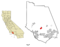
Location of Santa Paula in Ventura County
-
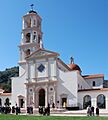
Thomas Aquinas Chapel
-
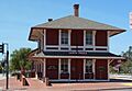
Historic train depot
-

Downtown Santa Paula with an agriculture mural
See also
 In Spanish: Santa Paula (California) para niños
