Santa Susana Pass facts for kids
Quick facts for kids Santa Susana Pass |
|
|---|---|

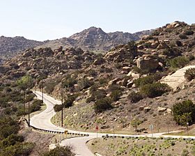
Santa Susana Pass Road looking west from Topanga Canyon Boulevard.
|
|
| Elevation | 1,200 feet (370 m) |
| Traversed by | |
| Location | Simi Valley / Chatsworth, Los Angeles, California, United States |
| Range | Santa Susana Mountains/Simi Hills |
| Coordinates | 34°16′05″N 118°37′59″W / 34.26806°N 118.63306°W |
The Santa Susana Pass is a special mountain pass in Southern California. It connects the San Fernando Valley (a part of Los Angeles) with the city of Simi Valley. This pass was once called the Simi Pass. It's a low area between the Simi Hills and the Santa Susana Mountains.
Many movies have used the Santa Susana Pass as a filming location. Some of these include Shooting High (1940), Man's Genesis (1912), Judith of Bethulia (1914), Jack and the Beanstalk (1917), and Range Warfare (1935).
Contents
Nature's Beauty at Santa Susana Pass
This pass is a natural dividing line. It separates the Simi Hills to the south from the Santa Susana Mountains to the north. It's super important for animals! It helps them move safely between these two mountain areas.
Amazing Rock Formations
The landscape here is full of cool sandstone rocks. You can see huge rock formations and many large boulders. It's like a giant outdoor sculpture park!
Plants and Animals Thrive Here
The area is home to different types of plant life. You'll find chaparral shrub forests and oak savannahs. There are also native bunchgrasses growing all around. Water sources in the pass provide homes for many birds, mammals, and reptiles. It's a busy place for nature!
A Journey Through Time: History of the Pass
The Santa Susana Pass has a long and interesting history. People have been using this route for thousands of years.
Native American Trails
Long ago, Native American tribes used this pass. The Tongva-Fernandeño, Chumash-Venturaño, and Tataviam-Fernandeño tribes all met here. They used a trail through the pass for about 8,000 years. It was an important pathway for them.
Spanish Explorers and Mexican Ranchos
The first Europeans to see the pass were Spanish explorers. This happened in 1770 during the Portolà expedition. This group was the first to explore California by land. They traveled through the pass on January 15, 1770. Later, the pass became part of the route to Mission San Fernando Rey de España. After 1834, local ranch owners in the San Fernando Valley used the trail. Over time, it became a rough wagon road.
California's Early Days: Stagecoaches and Roads
When California became a state, the pass continued to be an important route.
The Old Santa Susana Stage Road
In 1859, the state of California decided to improve the wagon road. They spent money to turn it into a stagecoach road. This new road is now known as the Old Santa Susana Stage Road. One part of the road was very steep and tricky. It was called the Devil's Slide. Horses often had their eyes covered, and chains were used to help the brakes on the steep hills. Passengers had to get out and walk down!
A Key Mail Route
During the American Civil War (which started in 1861), mail service changed. The government needed a new way to send mail between Los Angeles and San Francisco. So, they used the new wagon road over the Santa Susana Pass. The first mail stagecoach traveled through the pass on April 6, 1861. This road was a vital link between the Los Angeles Basin and Ventura County. It was the main way to travel by stagecoach between Los Angeles and San Francisco until 1876. That's when trains started running between the cities.
Historic Recognition
The Old Santa Susana Stage Road is very important. It is listed on the National Register of Historic Places. Parts of it are also recognized as historic monuments by Ventura County and the City of Los Angeles.
Modern Roads and Rail
Over the years, new and better ways to cross the pass were built.
New Roads for Cars
In 1893, a new, less steep road was planned. It was called "The New Santa Susanna Pass Road through William's Canon." This road opened in 1895 and avoided the difficult Devil's Slide. People often called it the Chatsworth Grade Road. When the Santa Susana Pass State Historic Park was created in 1998, they named this road El Camino Nuevo (The New Road).
The 1895 road was used until 1917. That's when the current Santa Susana Pass Road was built. This 1917 road was the first one for cars between the San Fernando and Simi Valleys. It was also the main road north to Santa Barbara and San Francisco for a while. In 1968, State Route 118, a freeway, opened north of the old auto road. This freeway was renamed the "Ronald Reagan Freeway" in 1994.
Railroad Tunnels
The Southern Pacific Railroad also built a way through the pass. They started building three railroad tunnels in 1898. The train route opened in 1904. The railroad also built the Santa Susana Depot in 1903.
Parks and Recreation Today
Today, the old wagon road and the rocky hills are part of the Santa Susana Pass State Historic Park. This park is open for everyone to explore. To the south of the old stage road is Sage Ranch Park. To the north of Route 118 is Rocky Peak Park. This park is part of the Rim of the Valley Trail Corridor.
See also
- Bell Moving Picture Ranch – Bell Location Ranch
- Burro Flats Painted Cave
- Corriganville Movie Ranch
- History of the San Fernando Valley
- Iverson Movie Ranch
- Old Santa Susana Stage Road
- Santa Susana Pass State Historic Park
- Santa Susana Tunnel
- Spahn Movie Ranch
 | Emma Amos |
 | Edward Mitchell Bannister |
 | Larry D. Alexander |
 | Ernie Barnes |

