Arroyo Calabasas facts for kids
Quick facts for kids Arroyo Calabasas ('Calabasas Creek') |
|
|---|---|
| Country | United States |
| Physical characteristics | |
| Main source | Calabasas, California |
| River mouth | Los Angeles River, California 34°11′43″N 118°36′07″W / 34.1952°N 118.601838°W |
| Basin features | |
| Basin size | Santa Monica Mountains, Simi Hills, southwest San Fernando Valley |
Arroyo Calabasas is a small stream, also known as Calabasas Creek. It is about 7 miles (11 kilometers) long. This creek is a tributary of the Los Angeles River. A tributary is a smaller stream that flows into a larger river. Arroyo Calabasas is located in the southwestern San Fernando Valley area of Los Angeles County, California.
Contents
What is Arroyo Calabasas?
Arroyo Calabasas is an important part of the local water system. It helps carry water from the hills down to the Los Angeles River. The word "Arroyo" means "creek" or "stream" in Spanish. So, its name simply means "Calabasas Creek."
Where Does it Flow?
The Arroyo Calabasas starts in the town of Calabasas. It forms when two smaller streams meet. These are Dry Canyon Creek and McCoy Canyon Creek. Dry Canyon Creek comes from the Santa Monica Mountains. McCoy Canyon Creek flows from the Simi Hills. This area is like a giant funnel, called a watershed, where all the rain and water collect.
From Calabasas, the creek flows northeast. It passes through areas like Woodland Hills and Canoga Park. In Canoga Park, Arroyo Calabasas meets another stream called Bell Creek. This meeting point is called a confluence. This special spot is considered the very beginning, or "headwaters," of the famous Los Angeles River.
How it Helps with Floods
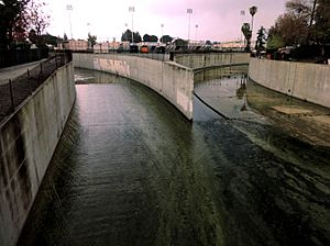
Today, the entire flow of Arroyo Calabasas is inside a concrete channel. This channel is a special structure built to control water. It helps prevent flooding, especially during heavy rains. This way, homes and businesses near the creek are kept safe from too much water.
Bridges Over the Creek
Many roads and paths cross over the Arroyo Calabasas. These crossings include bridges for cars and even some for people walking. Some of the main crossings were built in the 1960s. They allow traffic and people to move easily over the creek as it flows through the different neighborhoods.
 | Lonnie Johnson |
 | Granville Woods |
 | Lewis Howard Latimer |
 | James West |


