San Bruno, California facts for kids
Quick facts for kids
San Bruno
|
|
|---|---|
| Etymology: from Spanish, meaning 'St. Bruno' | |
| Motto(s):
"City with a Heart"
|
|
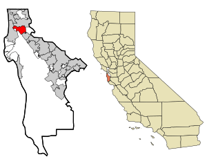
Location in San Mateo County and the state of California
|
|
| Country | United States |
| State | California |
| County | San Mateo |
| Region | San Francisco Bay Area |
| Region | Northern California |
| Incorporated | December 23, 1914 |
| Government | |
| • Type | Council–manager |
| Area | |
| • Total | 5.49 sq mi (14.22 km2) |
| • Land | 5.49 sq mi (14.22 km2) |
| • Water | 0.00 sq mi (0.00 km2) 0% |
| Elevation | 20 ft (6 m) |
| Population
(2020)
|
|
| • Total | 43,908 |
| • Density | 7,799.2/sq mi (3,011.29/km2) |
| Time zone | UTC−8 (Pacific) |
| • Summer (DST) | UTC−7 (PDT) |
| ZIP Codes |
94066, 94067, 94096, 94098
|
| Area code | 650 |
| FIPS code | 06-65028 |
| GNIS feature IDs | 277616, 2411778 |
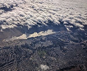
San Bruno is a city in San Mateo County, California. It was officially made a city in 1914. The name comes from St. Bruno. In 2020, about 43,908 people lived there. The city is located between South San Francisco and Millbrae. It is also close to San Francisco International Airport. San Bruno is about 12 miles (19 km) south of Downtown San Francisco.
Contents
About San Bruno's Location
San Bruno is nestled between South San Francisco and Millbrae. To its east is the San Francisco International Airport. The Golden Gate National Cemetery is to the northwest. The city is about 12 miles (19 km) south of downtown San Francisco.
The city covers about 5.5 square miles (14 km2) of land. It stretches from flat areas near San Francisco Bay to the hills of the Santa Cruz Mountains. These hills can be over 700 feet (210 m) high in some parts. San Bruno City Hall is about 41 feet (12 m) above sea level.
Some areas, like Mills Park and Crestmoor, are very hilly. They have canyons and ravines. Creeks flow from the hills towards San Francisco Bay. Just outside the city, near Skyline Boulevard, is San Andreas Lake. This lake is named after the San Andreas Fault. It is a reservoir that provides water to San Francisco and nearby communities, including parts of San Bruno.
San Bruno's Weather
San Bruno has a mild Mediterranean climate. This means it has warm, dry summers and cool, wet winters. The temperatures here are generally milder than in most of California. The climate is similar to an oceanic climate.
Since 1927, a weather station at the nearby San Francisco International Airport has recorded the weather. January is the coldest month. The average high is 55.9 °F (13.3 °C) and the average low is 42.9 °F (6.1 °C). Freezing temperatures happen only about 1.3 days a year. The coldest temperature ever recorded was 20 °F (−7 °C) on December 11, 1932. On that day, 1 inch (2.5 cm) of snow also fell.
September is the warmest month. The average high is 72.7 °F (22.6 °C) and the average low is 55.1 °F (12.8 °C). Temperatures go above 90 °F (32 °C) about 4 days a year. Fog and low clouds are common at night and in the morning during summer. Summers are usually very dry, with only light drizzle from the fog sometimes. Strong westerly winds are also common in the summer afternoons. The highest summer temperature ever was 106 °F (41 °C) on June 14, 1961.
Thunderstorms happen a few times a year, mostly in winter. They are usually short. Most rain falls from November to April. The average yearly rainfall is about 20.11 inches (511 mm) at the airport. In the higher hills, it can be over 32 inches (810 mm).
People in San Bruno
| Historical population | |||
|---|---|---|---|
| Census | Pop. | %± | |
| 1920 | 1,562 | — | |
| 1930 | 3,610 | 131.1% | |
| 1940 | 6,519 | 80.6% | |
| 1950 | 12,478 | 91.4% | |
| 1960 | 29,063 | 132.9% | |
| 1970 | 36,254 | 24.7% | |
| 1980 | 35,417 | −2.3% | |
| 1990 | 38,961 | 10.0% | |
| 2000 | 40,165 | 3.1% | |
| 2010 | 41,114 | 2.4% | |
| 2020 | 43,908 | 6.8% | |
| U.S. Decennial Census | |||
In 2010, San Bruno had 41,114 people. About 49.5% were White, 25.4% were Asian, and 29.2% were Hispanic or Latino.
Most people (99%) lived in homes. About 32.9% of homes had children under 18. The average household had 2.77 people. The average family had 3.31 people.
About 21% of the population was under 18 years old. The median age was 38.8 years. For every 100 females, there were about 97 males.
Parks and Recreation
San Bruno City Park is the biggest park in the city. It has shaded paths, hiking trails, and picnic areas. There's also a playground, a small baseball field, a swimming pool, and a recreation center. The recreation center has an indoor basketball court.
Junipero Serra County Park is a 100-acre (40 ha) park owned by San Mateo County. It has many hiking trails, picnic shelters, and barbecue spots. The park is named after Junípero Serra. He was a Franciscan friar who founded many Spanish missions in California. He often passed through what is now San Bruno. There is a small entry fee for cars, but you can walk in for free from San Bruno City Park.
Education in San Bruno
San Bruno has its own school district, the San Bruno Park School District. It runs five elementary schools and one middle school. For high school, most students go to Capuchino High School. This is the only high school in the city.
The city's main library is part of the Peninsula Library System. Skyline College, a community college, is also located in San Bruno.
San Bruno's History
Early Times
San Bruno was once home to the Ohlone village called Urebure. Spanish explorers visited the area in 1769. Later, Bruno de Heceta named San Bruno Creek after St. Bruno. The community eventually got its name from this creek.
When the San Francisco de Asís mission was built, this area became grazing land for mission animals. After the missions declined, the land became part of Rancho Buri Buri. Later, dairy farms became common here.
The city started as Clarks's Station, a stop for stagecoaches. An inn built in 1849 was a famous landmark. It was called Thorp's Place and later Uncle Tom's Cabin. A railroad station was built in San Bruno in the 1860s. This railroad is now known as Caltrain.
A U.S. Post Office first opened in San Bruno in 1875. It has been open continuously since 1898.
The 1900s
San Bruno really started to grow after the 1906 earthquake and fire. The first public school opened in 1906. By 1912, paving began for California's first state highway, El Camino Real. The nearby San Francisco International Airport opened in 1927. Famous aviator Charles Lindbergh visited the airport early on.
In 1911, aviator Eugene Ely made history at Tanforan Racetrack. He took off from the track and landed on a ship in San Francisco Bay. This was the first time an airplane successfully landed on a ship.
San Bruno became an official city in 1914. This was mainly to get the streets paved. The city grew quickly. By 1920, it had over 1,500 residents.

In 1930, the El Camino Theater opened. It showed movies with sound, replacing the older silent film theater. It was a popular spot for many years.
In 1939, the Golden Gate National Cemetery was created in San Bruno. During World War II, the local Tanforan Racetrack was used as the Tanforan Assembly Center. This was a temporary place where Japanese Americans were held before being sent to larger camps.
After World War II, San Bruno continued to grow. New neighborhoods were built. The Bayshore Freeway (U.S. Route 101) opened in 1947.
Before 1950, high school students from San Bruno went to schools in other cities. Finally, Capuchino High School opened in San Bruno on September 11, 1950. In 1954, the city opened a new library and city hall.
Actress and businesswoman Suzanne Somers was born in San Bruno in 1946. She went to local schools and graduated from Capuchino High School.
In 1953, San Bruno added the nearby community of Lomita Park.
On March 22, 1957, a magnitude 5.7 earthquake hit the area. It caused minor damage in the city.
A company called Eimac had a large factory in San Bruno for many years. They made parts for communication equipment. They even ran an FM radio station, KSBR.
Crestmoor High School opened in 1962 but closed in 1980 because fewer students were enrolling.
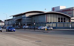
Tanforan Racetrack was a major landmark in San Bruno. Famous racehorses like Seabiscuit raced there. It closed in 1964 and was destroyed by a fire. A shopping mall, The Shops at Tanforan, was later built on the site.
During the late 1960s, the I-280 and I-380 freeways were built through San Bruno.
San Bruno is one of only two cities in the Bay Area that manages its own cable TV and internet system.
The Loma Prieta earthquake in 1989 caused some damage. The U.S. Postal Service's regional headquarters building was so damaged it had to be torn down. The site was rebuilt and now houses the headquarters for Wal-Mart's online retail services, Walmart.com.
The 2000s
The San Bruno BART station opened in 2003. This extended the transit system to Millbrae and the San Francisco International Airport.
2010 Explosion and Fire
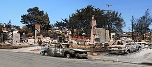
On September 9, 2010, a gas line broke. This caused a large fire that badly damaged a neighborhood. Eight people died, and many others were hurt. Thirty-eight homes were destroyed.
People first thought it was a plane crash. But officials confirmed no aircraft had crashed. Some residents had reported smelling natural gas before the explosion.
The National Transportation Safety Board investigated the cause. The gas company, PG&E, set aside $100 million to help the victims.
YouTube Headquarters
In 2007, YouTube moved its headquarters to San Bruno. It is located on Cherry Avenue near Interstate 380. The main building was built in 1997 for Gap Inc. It has a green roof and energy-efficient systems. YouTube has over 2,000 employees in San Bruno. It is the city's largest employer. In 2018, a shooting happened at the headquarters.
During World War II, the United States Navy had a base in San Bruno. It was used as a Classification Center and a personnel depot. After the war, it became a support center for Navy bases in the San Francisco Bay Area. The Navy decided to close the facility in 1994.
The federal government kept part of the land. The National Archives and Records Administration opened a facility there. One building became a Navy and Marine Corps Reserve Center. The rest of the land was sold to a developer. They built apartment buildings there.
San Bruno's Economy
San Bruno has several large employers. Here are some of the top ones:
| # | Employer | # of employees |
|---|---|---|
| 1 | Walmart Global eCommerce | 3,200 |
| 2 | YouTube | 2,380 |
| 3 | Skyline College | 680 |
| 4 | Artichoke Joe's | 389 |
| 5 | Target | 255 |
| 6 | San Bruno Park School District | 235 |
| 6 | City of San Bruno | 235 |
| 8 | Lucky Supermarkets | 199 |
| 9 | Lowe's | 180 |
| 10 | JC Penney | 164 |
Getting Around San Bruno
Roads

Interstate 280 goes through San Bruno. Interstate 380 is entirely within the city. It connects to U.S. Route 101. The city is also divided by California State Route 82.
Public Transportation
SamTrans runs bus services in San Mateo County, with many routes in San Bruno. For train travel, Caltrain serves San Bruno. The Bay Area Rapid Transit (BART) system also has stations here.
Both the San Bruno Caltrain and BART stations are very close to the Shops at Tanforan mall.
Air Travel
San Bruno is right next to San Francisco International Airport. You can get there using BART or US 101. Other major airports in the Bay Area, like Oakland and San Jose, can also be reached from San Bruno using public transit.
Famous People from San Bruno
- Wally Bunker, baseball player
- Emma Chamberlain, Internet personality
- Neal Dahlen, football administrator
- Luana DeVol, opera singer
- Keith Hernandez, baseball player
- Nelson Holderman, WW1 Medal of Honor recipient
- Ky Hollenbeck, kickboxer
- Ron "Pigpen" McKernan, musician
- The Mummies, garage punk band
- Ruggiero Ricci, violinist
- Suzanne Somers, actress
- Romaine Welds, traveler who visited every country
Sister City
- Narita, Chiba Prefecture, Japan
See also
 In Spanish: San Bruno (California) para niños
 | Janet Taylor Pickett |
 | Synthia Saint James |
 | Howardena Pindell |
 | Faith Ringgold |


