
Civic Center, San Francisco facts for kids
Quick facts for kids
Civic Center
UN Plaza
|
|
|---|---|
| San Francisco Civic Center Historic District | |
.jpg)
Aerial view of Civic Center at dusk in 2016, facing north. San Francisco City Hall is featured in the center.
|
|

Civic Center
Location in San Francisco
|
|
| Area | |
| • Total | 1.27 km2 (0.492 sq mi) |
| • Land | 1.27 km2 (0.492 sq mi) |
| Population
(2008)
|
|
| • Total | 10,101 |
| • Density | 7,925/km2 (20,525/sq mi) |
| ZIP codes |
94102, 94109
|
| Area codes | 415/628 |
|
San Francisco Civic Center Historic District
|
|

San Francisco Civic Center, looking west along UN Plaza to City Hall
|
|
| Location | Roughly bounded by Golden Gate Ave., 7th, Franklin, Hayes, and Market Sts., San Francisco, California |
| Area | 45.6 acres (18.5 ha) |
| Built | 1912 |
| Architectural style | Late 19th and 20th Century revivals Beaux-Arts |
| NRHP reference No. | 78000757 |
| Significant dates | |
| Added to NRHP | October 10, 1978 |
| Designated NHLD | February 27, 1987 |
The Civic Center in San Francisco, California, is a special area in the city. It's home to many of San Francisco's biggest government and cultural buildings. You'll find it a few blocks north of where Market Street and Van Ness Avenue meet.
This area features two large open spaces: Civic Center Plaza and United Nations Plaza. Many buildings here are built in a classic architectural style. Important historical events happened here. For example, the United Nations Charter was signed in the Veterans Building's Herbst Theatre in 1945. This led to the creation of the United Nations. Also, the 1951 Treaty of San Francisco was signed here. This treaty officially ended the Pacific War with Japan. Because of its importance, the San Francisco Civic Center was named a National Historic Landmark in 1987. It was also added to the National Register of Historic Places in 1978.
Contents
Where is the Civic Center Located?
The Civic Center is surrounded by several streets. Market Street is to the southeast. Franklin Street is to the west. Turk Street is to the north. Leavenworth Street, McAllister Street, and Charles J. Brenham Place are to the east. The Civic Center is next to the Tenderloin and Hayes Valley neighborhoods. Market Street separates it from the South of Market area.
History of the Civic Center Area
_(Civic_Center_crop).png)
San Francisco's first permanent City Hall was finished in 1898. It was built on a triangular piece of land that later became part of the Civic Center. This building took a very long time to build. It was supposed to be done in two years, but it took much longer and cost more than planned.
The current Civic Center was built after a big disaster. The earlier City Hall was destroyed in the 1906 earthquake and fire. Before the earthquake, an architect named Daniel Burnham had ideas for a new Civic Center. His plans included a large semi-circular plaza. This plaza would connect official buildings with streets like spokes on a wheel. However, his plans were never used.
.png)
After the earthquake, a temporary city hall was set up. But it took several years to plan a permanent one. A group of local architects, led by John Galen Howard, planned the current Civic Center. Their plan included five main buildings around a central rectangular plaza. These buildings were the City Hall, Auditorium, Main Library, Opera House, and State Office Building.
In 1912, the city approved $8.8 million to build the new Civic Center. At first, the new City Hall was planned for the old City Hall's spot. But later, it was decided to build it on the west side of the plaza. Construction on City Hall began on April 5, 1913.
.jpg)
The current San Francisco City Hall was finished in 1915. It was ready for the Panama–Pacific International Exposition, a big world's fair. Other important buildings followed. These included the Main Library (1916) and the California State Building (1926). The War Memorial Opera House and War Memorial Veterans Building were completed in 1932. The Old Federal Building was finished in 1936. The main open space, Civic Center Plaza, was completed by 1925.
During World War II, Army barracks and Victory gardens were built in Civic Center Plaza. In the 1950s to 1980s, new tall government buildings were added. An underground exhibition hall, Brooks Hall, was built in 1958. The Louise M. Davies Symphony Hall was added in 1980. In the 1990s, a new Main Library was built. The old Main Library became the Asian Art Museum. In 1998, part of the plaza was named the Joseph L. Alioto Performing Arts Piazza.
The Civic Center's central location and large open spaces make it a popular spot for big public gatherings. Many important rallies and protests have taken place here. It has been the site of large anti-war protests. It was also a key location for the Gay Rights Movement. People often gather here to express their views. Recently, it was a center for activism supporting same-sex marriage.
What to See and Do in Civic Center
Important Monuments to See
The Pioneer Monument is located on Fulton Street. It stands between the Library and the Asian Art Museum. This monument was funded by James Lick's estate. It celebrates the idea of Manifest Destiny.
United Nations Plaza was created in 1975. This happened when the Bay Area Rapid Transit subway was built. It's a special pedestrian area. It honors the United Nations and the signing of the UN Charter. The plaza was designed by Lawrence Halprin. It was updated in 2005. Today, it hosts a small farmers' market. You can also see a replica of a large statue of Simon Bolivar there.
Cultural Attractions in Civic Center
West of City Hall, on Van Ness Avenue, is the War Memorial Opera House. This is where the United Nations Charter was signed in 1945. The Treaty of San Francisco was also signed here in 1951. South of the Opera House is Davies Symphony Hall. To its north is the War Memorial Veterans Building. This building contains the Herbst Theatre. The Bill Graham Civic Auditorium and SHN Orpheum Theatre are also in the Civic Center.
Parks and Open Spaces for Fun
The main open space is Civic Center Plaza, just east of City Hall. This central location is perfect for many city events. You can find festivals and parades here. Some popular events include San Francisco's Gay Pride Parade. There's also the city's Earth Day celebration. The St. Patrick's Day parade and the San Francisco LovEvolution party also happen here.
The Helen Diller Civic Center Playgrounds were renovated and reopened in 2018. They are on the northeast and southeast corners of Civic Center Plaza. These playgrounds serve many nearby neighborhoods. They offer a great place for kids to play.
Getting Around: Transit Options
You can easily reach Civic Center by public transport. The Civic Center Station on Market Street is a subway stop. It serves both BART and the Muni Metro. The F Market historic streetcar line also runs nearby. Many Muni bus lines also stop in the area.
Education Hubs in Civic Center
Civic Center is home to several well-known higher education schools. These include Minerva Schools at KGI and the University of California, Hastings College of the Law. You'll also find the private The Art Institute of California – San Francisco. The The San Francisco Conservatory of Music is here too. Academy of Art University also has buildings in the neighborhood.
Other Interesting Places to Visit
The Fox Plaza condominium complex is also nearby. Look for the large art installation called Firefly by Ned Kahn. It's on the side of the San Francisco Public Utilities Commission building. This building is on Golden Gate Avenue.
In 2010, special streetlamps were installed. These lamps use both wind and solar power. They are part of the Civic Center's plan to be more sustainable.
Images for kids
-
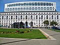
Ronald M. George State Office Complex: Earl Warren Building with the Hiram W. Johnson State Office Building behind
-
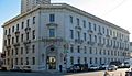
Department of Public Health

.JPG)


.JPG)
.JPG)
.JPG)
