
Redding, California facts for kids
Quick facts for kids
Redding, California
|
|||
|---|---|---|---|
| City of Redding | |||
.jpg) .JPG) .jpg) .jpg)  Top: Sundial Bridge at Turtle Bay; middle: Cascade Theatre, Hotel Lorenz; bottom: Old City Hall, Pine Street School
|
|||
|
|||

Location of Redding in Shasta County, California
|
|||

Redding, California
Location in California

Redding, California
Location in the United States
|
|||
| Country | United States | ||
| State | California | ||
| County | Shasta | ||
| Incorporated | October 4, 1887 | ||
| Founded by | Pierson B. Reading | ||
| Government | |||
| • Type | Council-manager | ||
| Area | |||
| • Total | 61.17 sq mi (158.44 km2) | ||
| • Land | 59.65 sq mi (154.48 km2) | ||
| • Water | 1.53 sq mi (3.96 km2) 2.50% | ||
| Elevation | 564 ft (172 m) | ||
| Population
(2020)
|
|||
| • Total | 93,611 | ||
| • Rank | 83rd in California | ||
| • Density | 1,530.34/sq mi (590.829/km2) | ||
| Demonym(s) | Reddingite | ||
| Time zone | UTC−8 (Pacific Time Zone) | ||
| • Summer (DST) | UTC−7 (PDT) | ||
| ZIP codes |
96001–96003, 96049, 96099
|
||
| Area code | 530 | ||
| FIPS code | 06-59920 | ||
| GNIS feature IDs | 277582, 2411531 | ||


Redding is a city located in Shasta County, California. It is the main city and center for business and culture in the Shasta Cascade area of Northern California. The city sits along the Sacramento River. It is about 162 miles (261 km) north of Sacramento. It is also about 120 miles (190 km) south of California's border with Oregon. In 2022, Redding had a population of 95,542 people.
Contents
How Redding Got Its Name
During the California Gold Rush, the area where Redding is now was called Poverty Flats. In 1868, a man named Benjamin B. Redding bought land there for the Central Pacific Railroad. He was a former politician from Sacramento. The railroad built a train station and a town in the area. They named the town Redding to honor Benjamin Redding.
In 1874, some local lawmakers wanted to change the name. They changed it to Reading for a short time. This was to honor Pierson B. Reading, who had owned a large piece of land in the area. He had arrived in 1843 and died in 1868. By 1880, the name was officially changed back to Redding.
A Look at Redding's Past
Early Indigenous People
The land where Redding is located was originally home to the Wintu tribe of Native Americans. At one point, the Wintu people had as many as 239 villages in the Shasta County area.
Spanish and Mexican Influence
Even though Europeans had explored California since 1542, the Wintu people were the only ones living in Northern California for a long time.
The first European settlement in this area was started in 1844. It was founded by Pierson B. Reading, an early California pioneer. He received a large land grant from Mexico, covering about 26,632 acres. This land is now where Redding and Cottonwood, California are. At that time, it was the northernmost non-native settlement in California.
The Gold Rush Era
During the Gold Rush, gold was found north and south of what is now Redding. However, the immediate area of Redding itself did not have much gold. This is why it was called Poverty Flats. In 1868, Benjamin B. Redding bought land for the Central Pacific Railroad. The railroad tracks reached the area in 1872. The town of Redding was officially created on October 4, 1887. In 1888, Redding became the county seat, taking the title from Shasta.
Redding in the 20th Century

In the early 1900s, Redding grew because of the copper and iron mining industry nearby. When mining slowed down, the economy and population also decreased by 1920. Things improved in the 1930s with the building of Shasta Dam. This dam was finished in 1945. Its construction caused Redding's population to almost double. It also helped other towns in the area grow.

Redding continued to grow in the 1950s. This was due to the growing lumber industry and tourism from the new dam. The building of Whiskeytown and Keswick dams also brought new workers and boosted the economy. The major highway Interstate 5 was built in the 1960s and 1970s. This helped with more development and tourism.
In the 1960s and 1970s, Redding grew even more by adding the community of Enterprise. People there voted to join Redding mainly to get cheaper electricity from the city's power company.
In the 1970s, the lumber industry faced problems. In the early 1990s, many lumber mills closed. This was because of efforts to protect the habitat of the Spotted Owl. This greatly affected the Redding area. However, the economy improved again. A boom in retail and housing in the late 1980s continued into the mid-1990s.
Also in the 1970s, a project called the Market Street Redevelopment Project started. It aimed to improve the downtown area and create the Midtown Mall. The goal was to stop buildings from getting old and to help downtown businesses. The mall had some difficulties, but the area continued to be improved over time.
Redding in the 21st Century
After the improvements to Midtown, property values in the area went up. More redevelopment continued. A plan for downtown in 2001 led to many changes. These included fixing up the historic Cascade Theatre. The roof of the Midtown Mall was removed to create an open-air street for walking. New signs were put up to help visitors find their way. A Health Sciences and University Center was built with Shasta College. Many buildings along California Street were also renovated.
In 2017, the city chose a new flag after holding a contest.
The 21st century has also seen several big wildfires near Redding. The Jones Fire in 1999 destroyed over 100 buildings. The Bear Fire followed in 2004. In July 2018, the Carr Fire greatly affected Redding. It destroyed at least 1,100 buildings and forced 38,000 people to leave their homes. Eight people also died. More recently, the Fawn Fire in 2021 caused over 4,000 people to evacuate. It also destroyed 185 buildings.
Where is Redding Located?
Redding covers about 61.2 square miles (158.4 square kilometers). Most of this area, about 59.6 square miles (154.4 square kilometers), is land. The remaining 1.5 square miles (3.9 square kilometers) is water.
Redding is at the very northwest end of the Central Valley. This area then changes into the Cascade foothills. Mountains surround the city to the north, east, and west. To the south, there is rich farmland. Some outer parts of the city are in the Cascade foothills. The southern and central areas are in the Sacramento Valley.
The average elevation in Redding is about 495 feet (151 meters). Areas north, east, or west of downtown are higher, between 550 and 800 feet (168 and 244 meters). Southern parts are lower, between 400 and 500 feet (122 and 152 meters).
The Shasta Dam on the Sacramento River helps protect Redding from floods. The dam can control very large amounts of water.
The soil in Redding is mostly clay or gravelly loam. It is slightly or moderately acidic.
Special Plants and Animals
There are some rare and endangered species in and around Redding. For example, the slender Orcutt grass is an endangered plant. It grows in eastern Redding near the airport, where there are special pools of water called vernal pools. These pools are also home to the vernal pool fairy shrimp, which is a protected species.
Redding's Climate

.jpg)
Redding has a hot-summer Mediterranean climate. This means it has very hot, dry summers and cool, wet winters. Redding is famous for its extremely high summer temperatures. This is true even though it is located fairly far north in the United States.
Winter, from October to April, is when Redding gets most of its rain. The weather is often rainy or foggy, and sometimes it snows. Summers are usually hot and dry, but thunderstorms can happen. The average high temperature in July is around 100°F (38°C). The highest temperature ever recorded in Redding was 119°F (48°C) on July 6, 2024. Redding gets a lot of sunshine, about 88% of the possible sunshine. This is one of the highest percentages in any U.S. city.
Summer nights in Redding are warmer than in other parts of the Sacramento Valley. The warmest night of the year usually averages 79°F (26°C). The hottest night ever recorded was 86°F (30°C) in June 2004.
Redding sometimes gets snow. It has received as much as 23 inches (58 cm) of snow in a single storm. This happened in December 1909 and December 1968. It rarely gets sleet or freezing rain. Frost is common from December to February. In spring, rain is common. Because Redding is near the Cascade and Klamath mountains, it gets more rain than most places in the Sacramento Valley. The coldest temperature recorded in Redding was 16°F (-9°C) on January 17, 2012, and December 9, 2009.
| Climate data for Redding Regional Airport, California (1991–2020 normals, extremes 1893–present) | |||||||||||||
|---|---|---|---|---|---|---|---|---|---|---|---|---|---|
| Month | Jan | Feb | Mar | Apr | May | Jun | Jul | Aug | Sep | Oct | Nov | Dec | Year |
| Record high °F (°C) | 87 (31) |
87 (31) |
93 (34) |
98 (37) |
109 (43) |
117 (47) |
119 (48) |
118 (48) |
116 (47) |
106 (41) |
99 (37) |
83 (28) |
119 (48) |
| Mean maximum °F (°C) | 70.5 (21.4) |
74.3 (23.5) |
80.7 (27.1) |
88.0 (31.1) |
97.4 (36.3) |
106.5 (41.4) |
110.5 (43.6) |
108.2 (42.3) |
104.9 (40.5) |
94.9 (34.9) |
79.8 (26.6) |
68.9 (20.5) |
112.0 (44.4) |
| Mean daily maximum °F (°C) | 57.2 (14.0) |
61.0 (16.1) |
65.7 (18.7) |
71.8 (22.1) |
82.0 (27.8) |
91.9 (33.3) |
99.9 (37.7) |
98.1 (36.7) |
92.3 (33.5) |
79.4 (26.3) |
64.4 (18.0) |
56.0 (13.3) |
76.6 (24.8) |
| Daily mean °F (°C) | 47.5 (8.6) |
50.5 (10.3) |
54.4 (12.4) |
59.4 (15.2) |
68.2 (20.1) |
77.1 (25.1) |
83.4 (28.6) |
81.0 (27.2) |
75.3 (24.1) |
64.8 (18.2) |
52.9 (11.6) |
46.6 (8.1) |
63.4 (17.4) |
| Mean daily minimum °F (°C) | 37.7 (3.2) |
40.1 (4.5) |
43.2 (6.2) |
47.0 (8.3) |
54.3 (12.4) |
62.4 (16.9) |
67.0 (19.4) |
63.9 (17.7) |
58.2 (14.6) |
50.2 (10.1) |
41.5 (5.3) |
37.2 (2.9) |
50.2 (10.1) |
| Mean minimum °F (°C) | 27.0 (−2.8) |
28.8 (−1.8) |
32.0 (0.0) |
34.5 (1.4) |
42.6 (5.9) |
51.3 (10.7) |
58.0 (14.4) |
56.1 (13.4) |
48.9 (9.4) |
39.1 (3.9) |
29.7 (−1.3) |
25.7 (−3.5) |
23.5 (−4.7) |
| Record low °F (°C) | 16 (−9) |
20 (−7) |
27 (−3) |
28 (−2) |
31 (−1) |
38 (3) |
48 (9) |
44 (7) |
39 (4) |
29 (−2) |
21 (−6) |
16 (−9) |
16 (−9) |
| Average precipitation inches (mm) | 6.04 (153) |
5.48 (139) |
4.62 (117) |
2.41 (61) |
1.81 (46) |
0.75 (19) |
0.07 (1.8) |
0.13 (3.3) |
0.45 (11) |
1.92 (49) |
3.53 (90) |
6.31 (160) |
33.52 (851) |
| Average snowfall inches (cm) | 1.1 (2.8) |
0.8 (2.0) |
0.0 (0.0) |
0.0 (0.0) |
0.0 (0.0) |
0.0 (0.0) |
0.0 (0.0) |
0.0 (0.0) |
0.0 (0.0) |
0.0 (0.0) |
0.0 (0.0) |
0.7 (1.8) |
2.6 (6.6) |
| Average precipitation days (≥ 0.01 in) | 12.2 | 10.9 | 11.7 | 8.1 | 6.1 | 2.9 | 0.5 | 0.6 | 1.4 | 4.7 | 8.8 | 12.6 | 80.6 |
| Average snowy days (≥ 0.1 in) | 0.4 | 0.3 | 0.0 | 0.0 | 0.0 | 0.0 | 0.0 | 0.0 | 0.0 | 0.0 | 0.0 | 0.1 | 0.8 |
| Source 1: NOAA | |||||||||||||
| Source 2: WRCC | |||||||||||||
People of Redding
| Historical population | |||
|---|---|---|---|
| Census | Pop. | %± | |
| 1880 | 600 | — | |
| 1890 | 1,821 | 203.5% | |
| 1900 | 2,946 | 61.8% | |
| 1910 | 3,572 | 21.2% | |
| 1920 | 2,962 | −17.1% | |
| 1930 | 4,188 | 41.4% | |
| 1940 | 8,109 | 93.6% | |
| 1950 | 10,256 | 26.5% | |
| 1960 | 12,773 | 24.5% | |
| 1970 | 16,659 | 30.4% | |
| 1980 | 42,103 | 152.7% | |
| 1990 | 66,462 | 57.9% | |
| 2000 | 80,865 | 21.7% | |
| 2010 | 89,861 | 11.1% | |
| 2020 | 93,611 | 4.2% | |
| U.S. Decennial Census | |||
.jpg)
What the 2020 Census Shows
In 2020, Redding had a population of 93,611 people. The table below shows the different groups of people living in Redding.
| Race / Ethnicity (NH = Non-Hispanic) | Pop 2000 | Pop 2010 | Pop 2020 | % 2000 | % 2010 | % 2020 |
|---|---|---|---|---|---|---|
| White alone (NH) | 69,293 | 73,038 | 68,751 | 85.69% | 81.28% | 73.44% |
| Black or African American alone (NH) | 828 | 1,025 | 1,299 | 1.02% | 1.14% | 1.39% |
| Native American or Alaska Native alone (NH) | 1,625 | 1,665 | 1,747 | 2.01% | 1.85% | 1.87% |
| Asian alone (NH) | 2,372 | 2,974 | 4,086 | 2.93% | 3.31% | 4.36% |
| Pacific Islander alone (NH) | 79 | 128 | 180 | 0.10% | 0.14% | 0.19% |
| Other race alone (NH) | 142 | 123 | 518 | 0.18% | 0.14% | 0.55% |
| Mixed race or Multiracial (NH) | 2,133 | 3,121 | 6,540 | 2.64% | 3.47% | 6.99% |
| Hispanic or Latino (any race) | 4,393 | 7,787 | 10,490 | 5.43% | 8.67% | 11.21% |
| Total | 80,865 | 89,861 | 93,611 | 100.00% | 100.00% | 100.00% |
What the 2010 Census Showed
The 2010 Census reported that Redding had 89,861 people. About 97.8% of the people lived in homes.
There were 36,130 households. About 30.5% of these had children under 18. About 44.3% were married couples. The average household had 2.43 people.
The population was spread out by age. About 22.8% were under 18. About 16.4% were 65 or older. The average age was 38.5 years.
Redding's Economy
_(cropped).jpg)
Redding is the main economic center for the Shasta Cascade region of Northern California.
In 2019, the Redding area was named one of the most dynamic areas in the United States. This means it has a strong and varied economy. Many different types of businesses employ people in Redding.
The Redding Cultural District is one of 14 special Arts and Culture Districts in California. It includes Downtown Redding, the Turtle Bay Complex, and city parks along the Sacramento River.
Major Employers in Redding
Here are some of the biggest employers in Redding:
| # | Employer | # of employees |
|---|---|---|
| 1 | Mercy Medical Center | 1,832 |
| 2 | Shasta County | 1,750 |
| 3 | City of Redding | 1,129 |
| 4 | Shasta Regional Medical Center | 856 |
| 5 | CA Transportation Department | 663 |
| 6 | Redding Rancheria | 523 |
| 7 | Wal-Mart | 450 |
| 8 | Shasta Union High School District | 406 |
| 9 | Shasta College | 352 |
| 10 | Blue Shield of California | 330 |
Fun Things to Do in Redding

Museums and Public Art
- Sculpture park at City Hall
- Sundial Bridge at Turtle Bay, designed by Santiago Calatrava
- Santiago Calatrava sculpture, at Domke Plaza
- Shasta Historical Society
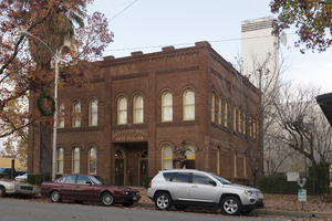
Interesting Buildings
- Hotel Lorenz
- Pilgrim Congregational Church
Places for Events
- Cascade Theatre
- The Dip
- IOOF Hall
- Riverfront Amphitheater
- Old City Hall
- Redding Civic Auditorium
- Axiom Repertory Theatre
Performing Arts Groups
- Riverfront Playhouse
- Axiom Repertory Theater
Education in Redding
.jpg)
.JPG)
Colleges and Universities
Public Colleges
- Shasta College
Private Colleges
- National University
- Shasta Bible College and Graduate School
- Simpson University
High Schools
Public High Schools
- Shasta High School
- Enterprise High School
- Foothill High School
- Pioneer High School
Other High Schools
- Freedom High School
- University Preparatory School
- North State Independence High School
- Redding Christian High School
- Liberty Christian High School
Charter Schools
- Chrysalis Charter School
- Monarch Learning Center
- Stellar Charter School
- Phoenix Charter Academy
- Redding Collegiate Academy
- Redding School of the Arts
- Rocky Point Charter School
- Shasta Charter Academy
Trade Schools
- Redding Institute of Technology
- Shasta School of Cosmetology
- CloudWise Academy
Media in Redding
Print Media
- Redding Record Searchlight (local newspaper)
- After Five (local magazine)
Television Stations
Radio Stations
Getting Around Redding

Main Roads
 Interstate 5 goes through the eastern part of Redding.
 CA 299 runs through the western, central, and northeastern parts of the city.
 CA 44 goes through the middle and eastern part of town.
 CA 273 also runs through the city.
Train and Bus Travel
Amtrak offers train service to Redding station. The Coast Starlight train runs daily. It travels between Seattle, Washington, and Los Angeles, California. It stops in cities like Portland, Oregon, Sacramento, California, and Oakland, California.
Amtrak Thruway also provides bus service twice a day. These buses connect to trains like the San Joaquins. This helps people travel to the San Francisco Bay Area, the San Joaquin Valley, and the Los Angeles area.
Redding's local bus system is called RABA (Redding Area Bus Authority). RABA has routes all over Redding and to nearby towns. You can also take buses from Redding to places like Burney, Alturas, and Weaverville. Other bus companies like Greyhound also serve Redding.
Air Travel
Redding has two airports. Redding Regional Airport is for commercial flights. It has flights from SkyWest (United Express) and Avelo Airlines. There are also plans for Core Airlines to offer flights to other cities soon. The smaller Benton Airpark is for general aviation (smaller planes).
Famous People from Redding
This list includes people who were born, grew up, worked, or were greatly influenced by Redding. It also includes music groups started here.
- David de Berry – theater composer and actor
- Eloise B. Cushing – attorney
- Shane Drake – music video director
- Ashley Parker Angel – recording artist and actor
- Francesca Eastwood – actor
- Lynsi Snyder – owner of In-N-Out
- Rich Eisen – sportscaster
- Kathleen Kennedy – film producer
- Matthew Kennedy – author
- Tommy Kirk – film actor
- Tom Meyer – professor, speaker, and author
- Kevin Rose – Internet entrepreneur
- Cory Asbury – contemporary Christian singer
- Duffy Bishop – electric blues singer and songwriter
- Brian Johnson – contemporary worship singer and songwriter
- Scott Joss – fiddle player, songwriter
- Randy Miller – drummer of The Myriad
- Craig Padilla – ambient electronic musician and film score composer
- Bryce Pinkham – actor and singer
- Jessica Pratt – singer/songwriter
- Roy Rogers – guitarist
- Bruce Turgon – musician, songwriter, producer
- Rick Bosetti – professional baseball player
- Greg Cadaret – MLB player
- Mel Hein – football player, 1938 MVP, NFL Hall of Fame inductee
- Paul Howard – former NFL player
- Eddie Machen – heavyweight boxer
- Buck Martinez – professional MLB player, manager, broadcaster
- Matt Nichols – Canadian Football League player
- Ryan O'Callaghan – NFL football player
- Frank Crowe – chief engineer and designer of the Hoover Dam
- Jonathan Foster – singer-songwriter
- Hilary Pecis (born 1979) – artist
- Bill Plummer – MLB player, coach and manager
- Megan Rapinoe – professional soccer player, Olympic gold medalist
- Ricky Ray – football player in the Canadian Football League
- Lynne Roberts – college basketball coach
- Jason Sehorn – former NFL player
- John Strohmayer – former MLB player and high school coach
- Raymond Jacobs – US Marine, said to be in photo of first flag raised on Iwo Jima
- Brian Sandoval – 29th governor of Nevada
- Sam Butcher – artist, Precious Moments, Inc.
- Jeffery Dangl – plant immunologist
- Bill Johnson – Christian minister and evangelist
- Michael Zagaris – sports and music photographer
- Terry Riley – American composer
See also
 In Spanish: Redding (California) para niños
