Weaverville, California facts for kids
Quick facts for kids
Weaverville
Ho'raqtu (Chimariko)
|
|
|---|---|

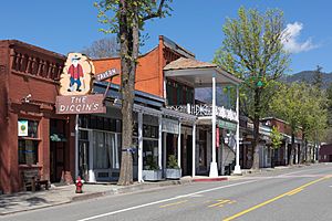
Main Street in April 2020
|
|

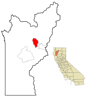
Location in Trinity County, California
|
|
| Country | United States |
| State | California |
| County | Trinity |
| Area | |
| • Total | 10.424 sq mi (26.999 km2) |
| • Land | 10.424 sq mi (26.999 km2) |
| • Water | 0 sq mi (0 km2) 0% |
| Elevation | 2,051 ft (625 m) |
| Population
(2020)
|
|
| • Total | 3,667 |
| • Density | 351.78/sq mi (135.820/km2) |
| Time zone | UTC−8 (Pacific) |
| • Summer (DST) | UTC−7 (PDT) |
| ZIP code |
96093
|
| Area code | 530 |
| FIPS code | 06-83794 |
| GNIS feature IDs | 1652649, 2409537 |
Weaverville is a small town in Trinity County, California, United States. It's the main town, or county seat, of Trinity County. The town's name in the Chimariko language is Ho'raqtu.
In 2020, about 3,667 people lived in Weaverville. This was a small increase from 3,600 people in 2010.
Contents
A Look Back: Weaverville's History
Gold Rush Beginnings
Weaverville was started in 1850 during the California Gold Rush. This was a time when many people came to California hoping to find gold. The town is located near the beautiful Trinity Alps Wilderness Area.
Chinese Miners and Chinatown
Long ago, about 2,000 Chinese gold miners lived in Weaverville. They had their own area called Chinatown. After the Gold Rush ended, many miners left. Most of Chinatown was destroyed in a big fire in 1911.
Historic Buildings and Landmarks
Even today, you can see many historic buildings and monuments in Weaverville. They help keep the town's history alive.
- The Joss House is California's oldest active Chinese temple. It was built in 1852, making it Weaverville's oldest building. It holds many Chinese items from the 1800s.
- You can take a self-guided walking tour of the historic downtown. You'll see charming shops and businesses. Some people even say some of these old buildings are haunted!
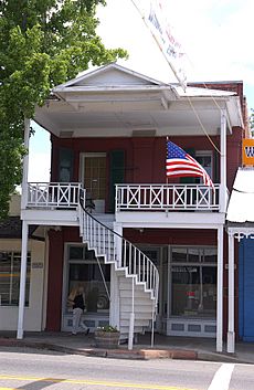
- Weaverville has unique Gold Rush-era buildings. Look for the famous spiral staircases on Main Street. There's also an old Bandstand and a red Courthouse.
- The Jake Jackson Museum on Main Street is another original building from the 1850s. It shows off old Gold Rush tools, photos, and other cool items.
- The Diggins Saloon and New York Saloon are still open today. They have been welcoming customers since the Gold Rush!
Local Economy and Recreation
For many years, logging (cutting down trees) and tourism were the main ways people made money in Weaverville. Today, Weaverville is known for its great trails and its historic downtown.
The Trinity Alps Basin Trails system starts in Weaverville. It's a network of hiking and biking trails. They range from easy to difficult and go through the Trinity Alps and around its beautiful lakes.
Trinity Lake and Local News
Trinity Lake is a man-made lake not far from Weaverville. It's a popular spot for camping, boating, and motorcycling. People have been enjoying it since the 1970s.
The Trinity Journal newspaper has been the main source of local news for Weaverville since 1856. It's one of California's oldest newspapers still being printed! You can find its office in Weaverville's Historic District.
Weaverville's Own Power
Weaverville has its own special electrical system. The town created its own power company, Trinity PUD. This allows them to make electricity from local water sources.
Weaverville's Location and Weather
Where is Weaverville?
Weaverville is located at coordinates 40°44′12″N 122°56′10″W. The town covers an area of about 10.4 square miles (26.9 square kilometers), and all of it is land.
Weaverville's Climate
Weaverville has a Mediterranean climate. This means it usually has warm, dry summers and mild, wet winters. However, because it's in an inland valley, the mornings can be colder.
The warmest month is usually July, with average high temperatures around 95.1°F (35.1°C). The coldest month is January, with average low temperatures around 31.2°F (-0.4°C).
It gets about 35.45 inches (900 mm) of rain each year. Snowfall is usually light, averaging about 8.7 inches (22 cm) per year.
| Climate data for Weaverville, California (1991–2020 normals, 1894–2020 extremes) | |||||||||||||
|---|---|---|---|---|---|---|---|---|---|---|---|---|---|
| Month | Jan | Feb | Mar | Apr | May | Jun | Jul | Aug | Sep | Oct | Nov | Dec | Year |
| Record high °F (°C) | 75 (24) |
82 (28) |
90 (32) |
94 (34) |
106 (41) |
113 (45) |
113 (45) |
116 (47) |
111 (44) |
104 (40) |
89 (32) |
85 (29) |
116 (47) |
| Mean maximum °F (°C) | 61.0 (16.1) |
69.2 (20.7) |
77.4 (25.2) |
84.8 (29.3) |
93.5 (34.2) |
101.0 (38.3) |
105.3 (40.7) |
104.4 (40.2) |
100.6 (38.1) |
91.0 (32.8) |
72.4 (22.4) |
59.1 (15.1) |
106.8 (41.6) |
| Mean daily maximum °F (°C) | 49.5 (9.7) |
55.3 (12.9) |
61.1 (16.2) |
67.6 (19.8) |
77.1 (25.1) |
86.1 (30.1) |
95.1 (35.1) |
94.5 (34.7) |
88.5 (31.4) |
75.2 (24.0) |
57.3 (14.1) |
46.7 (8.2) |
71.2 (21.8) |
| Daily mean °F (°C) | 40.3 (4.6) |
43.3 (6.3) |
47.2 (8.4) |
51.8 (11.0) |
59.4 (15.2) |
66.3 (19.1) |
73.7 (23.2) |
72.3 (22.4) |
66.2 (19.0) |
55.8 (13.2) |
45.4 (7.4) |
38.6 (3.7) |
55.0 (12.8) |
| Mean daily minimum °F (°C) | 31.2 (−0.4) |
31.2 (−0.4) |
33.3 (0.7) |
36.1 (2.3) |
41.8 (5.4) |
46.4 (8.0) |
52.2 (11.2) |
50.0 (10.0) |
43.9 (6.6) |
36.4 (2.4) |
33.4 (0.8) |
30.5 (−0.8) |
38.9 (3.8) |
| Mean minimum °F (°C) | 20.3 (−6.5) |
20.7 (−6.3) |
23.1 (−4.9) |
25.7 (−3.5) |
31.3 (−0.4) |
35.9 (2.2) |
43.8 (6.6) |
42.6 (5.9) |
34.8 (1.6) |
27.1 (−2.7) |
21.3 (−5.9) |
19.0 (−7.2) |
14.9 (−9.5) |
| Record low °F (°C) | −7 (−22) |
0 (−18) |
12 (−11) |
16 (−9) |
22 (−6) |
28 (−2) |
32 (0) |
29 (−2) |
23 (−5) |
14 (−10) |
4 (−16) |
−10 (−23) |
−10 (−23) |
| Average precipitation inches (mm) | 6.88 (175) |
5.69 (145) |
5.01 (127) |
2.62 (67) |
1.86 (47) |
0.93 (24) |
0.27 (6.9) |
0.17 (4.3) |
0.31 (7.9) |
2.10 (53) |
4.53 (115) |
7.57 (192) |
37.94 (964.1) |
| Average snowfall inches (cm) | 4.0 (10) |
3.7 (9.4) |
0.9 (2.3) |
0.7 (1.8) |
0.0 (0.0) |
0.0 (0.0) |
0.0 (0.0) |
0.0 (0.0) |
0.0 (0.0) |
0.0 (0.0) |
1.2 (3.0) |
5.0 (13) |
15.5 (39.5) |
| Average precipitation days (≥ 0.01 in) | 15.7 | 13.6 | 14.1 | 10.6 | 7.2 | 3.6 | 1.2 | 1.2 | 2.0 | 5.9 | 12.8 | 17.1 | 105 |
| Average snowy days (≥ 0.1 in) | 1.9 | 1.6 | 0.8 | 0.5 | 0.0 | 0.0 | 0.0 | 0.0 | 0.0 | 0.0 | 0.7 | 2.0 | 7.5 |
| Source 1: NOAA | |||||||||||||
| Source 2: National Weather Service | |||||||||||||
Who Lives in Weaverville?
Population Numbers
Here's how Weaverville's population has changed over the years:
| Historical population | |||
|---|---|---|---|
| Census | Pop. | %± | |
| 1860 | 777 | — | |
| 1870 | 816 | 5.0% | |
| 2010 | 3,600 | — | |
| 2020 | 3,667 | 1.9% | |
| U.S. Decennial Census 1850–1870 1880-1890 1900 1910 1920 1930 1940 1950 1960 1970 1980 1990 2000 2010 |
|||
People in 2010
In 2010, there were 3,600 people living in Weaverville. Most people (87.8%) were White. There were also people who were Native American (4.2%), Asian (1.1%), African American (0.3%), and from other backgrounds. About 7.1% of the people were Hispanic or Latino.
The average age of people in Weaverville in 2010 was about 44.4 years old.
Getting Around Weaverville
Main Roads
 State Route 299 runs right through the middle of Weaverville. This part of State Route 299 is also known as the Trinity Scenic Byway. It's a special road that goes through beautiful natural areas.
Cool Places to Visit in Weaverville
| Name | Image | Date listed | Location | Description |
|---|---|---|---|---|
| Weaverville Joss House State Historic Park | Added to California Historical markers in 1956 | Southwest corner of Main Street | This is a Taoist temple, also called "The Temple of the Forest Beneath the Clouds." It was built in 1874 and is the best-preserved example of a Chinese place of worship from the Gold Rush era in California. | |
| Racetrack-Airport-GolfCourse Historical Marker | Marker erected in 2007 | Located at current site of the Trinity County Golf Course. | This marker tells the history of a place that used to be a racetrack and an airport. Now, it's the Trinity County Golf Course. | |
| Weaverville Historic District | Added to NHRP 1971 | Located on both sides of Main Street | This area covers about 11 acres and includes 25 historic buildings. It's a great place to see the town's old architecture. |
See also
 In Spanish: Weaverville (California) para niños
 | Jewel Prestage |
 | Ella Baker |
 | Fannie Lou Hamer |


