
Cottonwood, California facts for kids
Quick facts for kids
Cottonwood, California
|
|
|---|---|

Front Street in Cottonwood, August 2022
|
|

Location in Shasta County and the state of California
|
|
| Country | |
| State | |
| County | Shasta |
| Area | |
| • Total | 13.225 sq mi (34.25 km2) |
| • Land | 13.225 sq mi (34.25 km2) |
| • Water | 0.00 sq mi (0 km2) 0% |
| Elevation | 492 ft (150 m) |
| Population
(2020)
|
|
| • Total | 6,268 |
| • Density | 473.95/sq mi (182.993/km2) |
| Time zone | UTC-8 (Pacific (PST)) |
| • Summer (DST) | UTC-7 (PDT) |
| ZIP code |
96022
|
| Area code(s) | 530 |
| FIPS code | 06-16630 |
| GNIS feature ID | 2407668 |
Cottonwood is a community in Shasta County, California, in the United States. It's known as a "census-designated place" (CDP), which means it's a community identified by the government for statistics, but it's not officially a city. In 2020, about 6,268 people lived here. Cottonwood has grown quite a bit, as its population was 3,316 in 2010. This area started as a stagecoach stop way back in 1849, and its first Post Office opened in 1852. Cottonwood is located about 15 miles (24 km) from both Redding and Red Bluff, and about 4 miles (6.4 km) south of Anderson.
Contents
Welcome to Cottonwood, California!
A Look at Cottonwood's Past
Cottonwood has an interesting history! For example, a winning ticket for one of the biggest Mega Millions jackpots ever was sold right here. The drawing for this amazing $1.22 billion prize happened on December 27, 2024.
Thinking About Becoming a City
Some people in Cottonwood have thought about the community becoming an official city. This process is called "incorporation." If Cottonwood became a city, it could make its own rules about things like building new homes and businesses. It would also help prevent nearby cities, like Anderson, from expanding into Cottonwood's surrounding areas.
Cottonwood isn't the only community in Shasta County thinking about this. Other places like Burney, Shingletown, Fall River Mills, and McArthur have also shown interest in becoming cities. Sometimes, smaller communities might even consider joining together to form one larger city. However, cities in California cannot cross county lines, which means a city must stay within one county.
Where is Cottonwood?
.png)
Cottonwood is located in a beautiful part of California. The entire community covers about 13.2 square miles (34.2 square kilometers) of land. A special feature of Cottonwood is that it sits on both sides of the Cottonwood Creek, which is how the town got its name! This creek eventually flows into the Sacramento River.
Who Lives in Cottonwood?
The population of Cottonwood has grown significantly over the years. In 1970, about 1,288 people lived here. By 2020, the population had grown to 6,268 people!
Cottonwood's Population in 2020
In 2020, the community of Cottonwood had 6,268 residents. Most people identified as White, but there were also people from many other backgrounds, including Native American, Asian, Black or African American, and Pacific Islander. About 11% of the population identified as Hispanic or Latino.
There were 2,325 households in Cottonwood. Many of these households (about 53.6%) were married couples. About 24.5% of the population was under 18 years old, meaning there are many kids and teenagers in Cottonwood! The average age of residents was about 39.8 years.
In 2023, the US Census Bureau estimated that the average income for a household in Cottonwood was around $96,679 per year.
Cottonwood's Population in 2010
Back in 2010, Cottonwood had a population of 3,316 people. Similar to 2020, most residents identified as White, with other groups including Native American, Asian, African American, and Pacific Islander also living in the community. About 10.6% of the population was Hispanic or Latino.
There were 1,200 households. About 41.7% of these households had children under 18 living in them. The median age was 35.8 years.
How Cottonwood is Governed
Even though Cottonwood isn't an official city, its residents are represented in government at different levels.
- State Government: In the California State Legislature, Cottonwood is part of the 1st State Senate District and the 1st State Assembly District. These representatives help make laws for California.
- Federal Government: For the United States government, Cottonwood is in the 1st Congressional District. This means residents vote for a representative who goes to Washington D.C. to help make national laws.
Schools in Cottonwood
Cottonwood has several schools that serve students from kindergarten through high school.
- West Valley High School is for students in grades 9-12. About 900 students attend this high school.
- West Cottonwood Junior High School serves students in grades 5-8.
- North Cottonwood Elementary is an elementary school for younger students.
- Cottonwood Creek Charter is a charter school that teaches students from kindergarten all the way through 8th grade. About 250 students attend this school.
Some schools, like Evergreen Elementary and Evergreen Middle, are located just across the county line in Tehama County but also serve students from the Cottonwood area.
Famous People from Cottonwood
Cottonwood has been home to some notable individuals!
- Tom Hubert is a former NASCAR driver. He was born in Cottonwood and later became a crew member for a racing team.
- Nicole Teter is a talented 800-meter runner. She has won many awards, including three USA Indoor championships. Nicole also holds the American record for the indoor 800m race and competed in the 2008 Olympics! She graduated from West Valley High School in Cottonwood.
Gallery
- Cottonwood, California
-
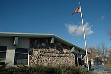
Cottonwood Post Office
-
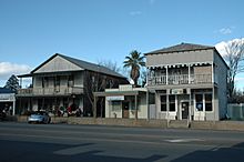
North side of Front Street
-
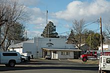
Cottonwood Fire Dept.


See also
 In Spanish: Cottonwood (California) para niños
