McArthur, California facts for kids
Quick facts for kids
McArthur
|
|
|---|---|

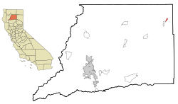
Location in Shasta County and the state of California
|
|
| Country | |
| State | |
| County | Shasta |
| Area | |
| • Total | 1.016 sq mi (2.631 km2) |
| • Land | 1.001 sq mi (2.593 km2) |
| • Water | 0.015 sq mi (0.038 km2) 1.44% |
| Elevation | 3,195 ft (1,009 m) |
| Population
(2020)
|
|
| • Total | 334 |
| • Density | 328.7/sq mi (126.95/km2) |
| Time zone | UTC-8 (Pacific (PST)) |
| • Summer (DST) | UTC-7 (PDT) |
| ZIP code |
96056
|
| Area code(s) | 530 |
| FIPS code | 06-44700 |
| GNIS feature ID | 0263294 |
McArthur is a small community in Shasta County, California, in the United States. It's called a "census-designated place" (CDP), which means it's an area the government counts for population, but it's not an official city. In 2020, about 334 people lived there. McArthur is a quiet ranching community. It is located about 4 miles (6.4 km) east of Fall River Mills.
About McArthur
McArthur is a small place in northern California. It is known for its peaceful, rural setting. The community is surrounded by beautiful natural areas.
Where is McArthur?
McArthur is located in Shasta County. Its exact location is 41°3′2″N 121°23′59″W / 41.05056°N 121.39972°W. The total area of McArthur is about 1.0 square mile (2.6 square kilometers). Most of this area is land, with a small part being water.
What's the Weather Like?
McArthur has a type of weather called a warm-summer Mediterranean climate. This means it has warm, dry summers and mild, wet winters. It's often abbreviated as "Csb" on climate maps.
| Climate data for McArthur | |||||||||||||
|---|---|---|---|---|---|---|---|---|---|---|---|---|---|
| Month | Jan | Feb | Mar | Apr | May | Jun | Jul | Aug | Sep | Oct | Nov | Dec | Year |
| Record high °F (°C) | 66 (19) |
72 (22) |
79 (26) |
86 (30) |
92 (33) |
103 (39) |
106 (41) |
104 (40) |
103 (39) |
94 (34) |
82 (28) |
63 (17) |
106 (41) |
| Mean daily maximum °F (°C) | 43.0 (6.1) |
47.9 (8.8) |
54.5 (12.5) |
62.4 (16.9) |
70.8 (21.6) |
78.2 (25.7) |
87.6 (30.9) |
86.4 (30.2) |
80.4 (26.9) |
68.6 (20.3) |
54.9 (12.7) |
44.7 (7.1) |
65.2 (18.4) |
| Mean daily minimum °F (°C) | 20.7 (−6.3) |
24.2 (−4.3) |
29.0 (−1.7) |
34.3 (1.3) |
40.3 (4.6) |
45.9 (7.7) |
49.9 (9.9) |
46.4 (8.0) |
40.9 (4.9) |
33.4 (0.8) |
26.6 (−3.0) |
22.6 (−5.2) |
34.5 (1.4) |
| Record low °F (°C) | −18 (−28) |
−15 (−26) |
3 (−16) |
10 (−12) |
24 (−4) |
28 (−2) |
35 (2) |
30 (−1) |
21 (−6) |
7 (−14) |
−17 (−27) |
−18 (−28) |
27.4 (−2.6) |
| Average precipitation inches (mm) | 2.69 (68) |
2.38 (60) |
2.20 (56) |
1.53 (39) |
1.22 (31) |
0.85 (22) |
0.18 (4.6) |
0.18 (4.6) |
0.47 (12) |
1.23 (31) |
2.35 (60) |
2.94 (75) |
18.22 (463.2) |
| Average snowfall inches (cm) | 8.4 (21) |
4.1 (10) |
3.2 (8.1) |
3.6 (9.1) |
0.9 (2.3) |
0.1 (0.25) |
0 (0) |
0 (0) |
0.5 (1.3) |
0.4 (1.0) |
2.7 (6.9) |
11 (28) |
34.9 (89) |
| Average precipitation days | 8 | 6 | 7 | 5 | 7 | 6 | 1 | 2 | 2 | 4 | 8 | 10 | 66 |
| Source 1: WeatherBase | |||||||||||||
| Source 2: National Weather Service | |||||||||||||
Who Lives in McArthur?
In 2020, the population of McArthur was 334 people. This was a small decrease from 338 people in 2010.
Based on the 2010 census, most residents were White. About 4.4% were Native American. A significant portion, about 29%, identified as being from other races. Around 35% of the people in McArthur were of Hispanic or Latino background.
The average age in McArthur in 2010 was about 39.6 years old. About 27% of the population was under 18 years old. Around 17% of the residents were 65 years or older.
In 2000, there were 365 people living in McArthur. The racial makeup was similar, with about 71.8% White and 5.2% Native American. About 24.9% of the population identified as Hispanic or Latino. The median age in 2000 was 38 years.
See also
 In Spanish: McArthur (California) para niños
 | Audre Lorde |
 | John Berry Meachum |
 | Ferdinand Lee Barnett |

