Anderson, California facts for kids
Quick facts for kids
Anderson, California
|
|||
|---|---|---|---|

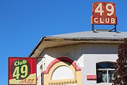
Club 49
|
|||
|
|||
| Nickname(s):
City of Opportunity
|
|||

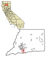
Location of Anderson in Shasta County, California
|
|||
| Country | United States | ||
| State | California | ||
| County | Shasta | ||
| Incorporated | January 16, 1956 | ||
| Government | |||
| • Type | Council-manager | ||
| Area | |||
| • Total | 7.21 sq mi (18.68 km2) | ||
| • Land | 7.03 sq mi (18.21 km2) | ||
| • Water | 0.18 sq mi (0.47 km2) 3.74% | ||
| Elevation | 430 ft (132 m) | ||
| Population
(2020)
|
|||
| • Total | 11,323 | ||
| • Density | 1,610.44/sq mi (621.77/km2) | ||
| Time zone | UTC-8 (Pacific (PST)) | ||
| • Summer (DST) | UTC-7 (PDT) | ||
| ZIP code |
96007
|
||
| Area code(s) | 530 | ||
| FIPS code | 06-02042 | ||
| GNIS feature ID | 0277470 | ||
| Website | http://ci.anderson.ca.us/ | ||
Anderson is a city in Shasta County, California. It is located about 10 miles south of Redding. In 2020, its population was 11,323 people. This was an increase from 9,932 people in 2010.
The city is about 138 miles north of Sacramento. Anderson started as a town built around a railroad. It is near the northern part of California's Central Valley.
The city was named after Elias Anderson. He was a ranch owner who gave land to the Oregon and California Railroad. This allowed them to build tracks and a train station. Elias Anderson was also a farmer, hotel owner, and postmaster.
Contents
History of Anderson
The railroad came to the Anderson area in 1872. The city gets its name from Elias Anderson. He owned the biggest land area nearby. Today, Anderson River Park is on some of the land Elias Anderson originally owned.
Elias Anderson bought the American Ranch in 1856. He built the American Ranch Hotel in what is now downtown Anderson. The local post office was inside this hotel. In 1872, he gave land to the Central Pacific Railroad. In return, the railroad named the train depot after him.
Geography and Climate
Anderson is located at 40°27′8″N 122°17′48″W. The city covers a total area of about 7.21 square miles (18.68 square kilometers). Most of this area is land. A small part, about 0.18 square miles (0.47 square kilometers), is water.
Climate in Anderson
Anderson has a "Hot-summer Mediterranean climate." This means it has hot, dry summers and mild, wet winters. It's similar to the climate found around the Mediterranean Sea.
Population Information
| Historical population | |||
|---|---|---|---|
| Census | Pop. | %± | |
| 1890 | 508 | — | |
| 1960 | 4,492 | — | |
| 1970 | 5,492 | 22.3% | |
| 1980 | 7,381 | 34.4% | |
| 1990 | 8,299 | 12.4% | |
| 2000 | 9,022 | 8.7% | |
| 2010 | 9,932 | 10.1% | |
| 2020 | 11,323 | 14.0% | |
| U.S. Decennial Census | |||
Population in 2010
In 2010, Anderson had a population of 9,932 people. The city had about 1,500 people per square mile. Most residents, about 83.3%, were White. Other groups included Native American, Asian, African American, and Pacific Islander people. About 10.8% of the population was Hispanic or Latino.
There were 3,944 households in Anderson. Many households, about 36.8%, had children under 18 living there. The average household had about 2.52 people. The average family size was about 3.07 people.
The age of people in Anderson varied. About 27.6% of the population was under 18 years old. About 12.8% of people were 65 or older. The average age in Anderson was 34.1 years.
Population in 2000
In 2000, Anderson had 9,022 people. The population density was about 1,412 people per square mile. The racial makeup was similar to 2010, with most people being White (86.51%). About 7.30% of the population was Hispanic or Latino.
There were 3,372 households. About 39.3% of these households had children under 18. The average household size was 2.64 people. The average family size was 3.14 people.
About 31.6% of the population was under 18 years old. About 13.9% of people were 65 or older. The average age was 32 years.
Education
Anderson has several schools for students.
High Schools
- Anderson Union High School
- North Valley High School
- Anderson New Technology High School
Elementary Schools
- Anderson Heights Elementary School
- Anderson Middle School
- Northern Summit Academy
- Meadow Lane Elementary
Recreation
Anderson is home to several parks where people can enjoy outdoor activities.
Anderson River Park
Anderson River Park is located along the Sacramento River. It has many features for fun. You can find athletic fields, picnic areas, and places to fish. There are also play structures for kids and a disc golf course.
In 2020, the city added River Splash to the park. This is a new water play area in Shasta County. River Splash has big shade structures, picnic tables, and restrooms. It has a large water play area with water spray tunnels and a tipping bucket. There are also 35 water jets with LED lights that spray water.
North Volonte Park
North Volonte Park is a developed park. It has fields for softball and baseball. There is also a skate park for skateboarding and scootering.
South Volonte Park
South Volonte Park is located behind North Volonte Park. This park is a wetlands area. It has a jogging trail around it. You can also find exercise equipment there.
See also
 In Spanish: Anderson (California) para niños
 | Roy Wilkins |
 | John Lewis |
 | Linda Carol Brown |


