
Dixon, California facts for kids
Quick facts for kids
City of Dixon
|
||
|---|---|---|

Aerial view of Dixon
|
||
|
||
| Nickname(s):
Purple Heart City, Dairy City
|
||

Location of Dixon in Solano County, California
|
||

Dixon, California
Location in the United States
|
||
| Country | United States | |
| State | California | |
| County | Solano | |
| Incorporated | March 30, 1878 | |
| Named for | Thomas Dickson | |
| Area | ||
| • Total | 7.20 sq mi (18.64 km2) | |
| • Land | 7.10 sq mi (18.39 km2) | |
| • Water | 0.10 sq mi (0.25 km2) 1.36% | |
| Elevation | 62 ft (19 m) | |
| Population
(2020)
|
||
| • Total | 18,988 | |
| • Density | 2,674.37/sq mi (1,032.53/km2) | |
| Time zone | UTC−8 (Pacific) | |
| • Summer (DST) | UTC−7 (PDT) | |
| ZIP code |
95620
|
|
| Area code | 707 | |
| FIPS code | 06-19402 | |
| GNIS feature IDs | 1655973, 2410343 | |

Dixon is a city in northern Solano County, California, United States. It is about 23 miles (37 km) from Sacramento, the state capital. Dixon has a hot-summer Mediterranean climate. This means it has hot, dry summers and mild, wet winters. In 2020, about 18,988 people lived there. Other cities nearby include Vacaville, Winters, and Davis.
Contents
History of Dixon

Dixon's story began during the California Gold Rush in the mid-1800s. A community called Silveyville was started in 1852 by Elijah Silvey. It was a stopping point for miners traveling between the Pacific coast and the gold fields of Sacramento.
In 1868, the Central Pacific railroad built tracks that passed a few miles from Silveyville. To be closer to the new train line, the people of Silveyville decided to move their whole town. One of the oldest buildings still standing from this 1871 move is the Dixon Methodist Church.
How Dixon Got Its Name
The city was first going to be named "Dicksville." This was in honor of Thomas Dickson, who gave 10 acres of his land for a railroad station. This happened after Silveyville moved to the new spot.
However, in 1872, the first train shipment arrived from San Francisco. It was accidentally addressed to "Dixon." People liked this shorter name, and it has been used ever since. Today, the city has grown mostly between the railroad tracks and Interstate-80.

The city of Dixon has its own local government. This includes a mayor and city council members. They work to manage the city's services. These services include a police department, a fire department, and a water system.
Geography of Dixon
Dixon is located at 38°26′57″N 121°49′37″W.
The city covers a total area of about 7.1 square miles (18.4 square kilometers). Most of this area, about 7.0 square miles (18.1 square kilometers), is land. A small part, about 0.1 square miles (0.26 square kilometers), is water.
Population and People
| Historical population | |||
|---|---|---|---|
| Census | Pop. | %± | |
| 1870 | 317 | — | |
| 1890 | 1,082 | — | |
| 1900 | 788 | −27.2% | |
| 1910 | 827 | 4.9% | |
| 1920 | 926 | 12.0% | |
| 1930 | 1,000 | 8.0% | |
| 1940 | 1,108 | 10.8% | |
| 1950 | 1,714 | 54.7% | |
| 1960 | 2,970 | 73.3% | |
| 1970 | 4,432 | 49.2% | |
| 1980 | 7,541 | 70.1% | |
| 1990 | 10,401 | 37.9% | |
| 2000 | 16,103 | 54.8% | |
| 2010 | 18,351 | 14.0% | |
| 2020 | 18,988 | 3.5% | |
| 2023 (est.) | 19,309 | 5.2% | |
| U.S. Decennial Census | |||
Dixon has grown quite a bit over the years. In 1870, only 317 people lived here. By 2020, the population had grown to 18,988 people.
Life in Dixon
In 2010, the average household in Dixon had about 3.13 people. Many households, about 47.4%, had children under 18 living in them. The median age of people in Dixon was 33.3 years. This means half the people were younger than 33.3, and half were older.
Most people in Dixon live in homes they own. About 66.6% of homes were owner-occupied in 2010. The rest were rented.
Fun Places to Visit

Dixon has some interesting places to see. The Jackson Fay Brown House and the Dixon Carnegie library are both listed on the National Register of Historic Places. This means they are important historical sites.
Cool Patch Pumpkins Maze
Dixon is home to the world's largest temporary corn maze! In 2014, Matt and Mark Cooley, who own Cool Patch Pumpkins, set a Guinness World Record. Their corn maze was huge, covering 60 acres (about 24 hectares). That's like 45 football fields!
Milk Farm Sign
You can also spot a very tall sign for the Milk Farm Restaurant. It's 100 feet (30 meters) tall and was built in 1963. It still stands today where State Route 113 and Interstate 80 meet.
Dixon May Fair
Dixon is famous for the Dixon May Fair. It's California's oldest fair, starting way back in 1885 as a May Day celebration. It's even older than the Solano County Fair! A stage at the fairgrounds is named after country music singer Jon Pardi, who grew up in Dixon.
Famous People from Dixon
- Spencer Webb - A football player for the Oregon Ducks.
- Jon Pardi - A popular country music singer and songwriter.
- Nick Watney - A professional golfer.
- Dave Ball - A professional NFL football player.
- Espinoza Paz - A Mexican musician and composer.
- Joe Craven - A professional musician and music educator.
Getting Around Dixon

Two main roads pass through Dixon: Interstate 80 and California State Route 113.
The Union Pacific Railroad also has a main train line that goes through Dixon. This line connects Oakland and Sacramento. It was built in 1868 by the California Pacific Railroad.
Amtrak trains, like the Capitol Corridor, also use this line. However, they don't stop in Dixon. The closest train stations are in Davis and Fairfield–Vacaville.
In 2006, Dixon built a train station near downtown. But trains don't stop there yet. For now, the building is used as the city's Chamber of Commerce.
For local travel, Dixon has a shuttle bus service called Dixon Readi-Ride. There's also a Park & Ride lot. From there, you can catch a bus that goes to Fairfield Transportation Center and downtown Sacramento.
Dixon's Economy
Dixon has several important employers that provide jobs for many people.
Main Employers
Here are some of the top employers in Dixon:
| # | Employer | # of Employees |
|---|---|---|
| 1 | Dixon Unified School District | 346 |
| 2 | Walmart | 300 |
| 3 | Cardinal Health | 250 |
| 4 | Basalite | 193 |
| 5 | Altec Industries | 190 |
| 6 | Dixon Canning (Campbell's) | 182 |
| 7 | Superior Packing | 164 |
| 8 | City of Dixon | 156 |
| 9 | Gold Star Foods | 99 |
| 10 | First Northern Bank | 74 |
News and Media
The Dixon Independent Voice newspaper started in 1993. It is published every week and is the main newspaper in the area today. The Dixon Tribune newspaper was founded in 1874 but stopped publishing in 2024.
Schools in Dixon

Dixon has public schools managed by the Dixon Unified School District. There are also some private schools.
High Schools
- Dixon High School
- Maine Prairie High School (a continuation school)
Middle Schools
- Dixon Montessori Charter School
- John Knight Middle School
- Neighborhood Christian Middle School
Elementary Schools
- Anderson
- Gretchen Higgins
- Tremont
- Neighborhood Christian School
- Dixon Montessori Charter School (now in the old Silveyville facility)
- Easter Seals Special Education Center (shares the Silveyville facility)
Images for kids
-

Midway at the Dixon May Fair
-
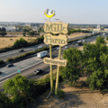
Milk Farm Sign along Interstate 80 in Dixon
-
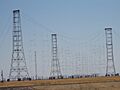
Voice of America Transmitters


See also
 In Spanish: Dixon (California) para niños
