Crockett, California facts for kids
Quick facts for kids
Crockett
|
|
|---|---|
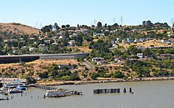
Looking south towards Crockett from the Carquinez Strait, July 14, 2010. Courtesy Federico Pizano.
|
|
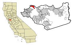
Location in Contra Costa County and California
|
|
| Country | United States |
| State | California |
| County | Contra Costa |
| Area | |
| • Total | 1.06 sq mi (2.75 km2) |
| • Land | 1.06 sq mi (2.75 km2) |
| • Water | 0.00 sq mi (0.00 km2) 0% |
| Elevation | 128 ft (39 m) |
| Population
(2020)
|
|
| • Total | 3,242 |
| • Density | 3,052.73/sq mi (1,178.38/km2) |
| Time zone | UTC-8 (PST) |
| • Summer (DST) | UTC-7 (PDT) |
| ZIP code |
94525
|
| Area code(s) | 510, 341 |
| FIPS code | 06-17274 |
| GNIS feature IDs | 277495, 2407683 |
Crockett (once called Crockettville) is a small community in Contra Costa County, California. It's part of the San Francisco Bay Area. In 2020, about 3,242 people lived there. Crockett is located about 28 miles (45 km) northeast of San Francisco. Other nearby towns include Port Costa, Martinez, and Rodeo.
Contents
History of Crockett
Crockett is built on land that was once part of a Mexican land grant called Rancho El Pinole. This land was given to a person named Ygnacio Martinez. The town is named after Joseph B. Crockett, who was a judge in California.
The town began in 1866 when Thomas Edwards Sr. bought a large piece of land from Judge Crockett. Edwards built his home in 1867. When more people moved to the area, he opened the first general store. Edwards' original home, called "The Old Homestead," is still standing today. It is a California Historical Landmark. The post office opened in 1883 and was first called Crocketville. Later that year, the name was changed to Crockett.
Crockett's "Sugar Town" Days
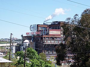
In 1906, a group of Hawaiian sugar cane farmers bought a factory in Crockett. They changed it to refine sugar. This company, called the California and Hawaiian Sugar Company (C&H), became very important to Crockett. It turned Crockett into a "company town." This means that the company owned most of the businesses and homes, and employed most of the people.
C&H brought sugar cane from Hawaii by ship to Crockett. There, the factory turned it into different sugar products. By the 1920s, C&H employed almost all the people living in Crockett. At its busiest, before World War II, about 2,500 people worked there. C&H even helped its workers get loans to build their homes. The company also supported many school and community programs.
In 1938, there was a labor strike at the C&H factory. This was a time when workers stopped working to ask for better pay or conditions.
Changes Over Time
By the 1960s, C&H started to face challenges. The company made less money and had to lay off many workers. In 1984, C&H wanted to build a new power plant. This plant would help the sugar factory and provide cheaper electricity for Crockett. Many residents formed a group to protest the plan.
After nine years, the power plant was built. But C&H agreed to make big changes. They also agreed to give Crockett $300,000 each year for 30 years. This money mostly helps pay for the town's police and volunteer firefighters.
In 1993, the Hawaiian sugar farmers sold C&H to another company. Later, in 2006, American Sugar Refining bought C&H. The Crockett factory stopped processing Hawaiian sugar in 2017. Now, raw sugar comes from other parts of the world, like Australia and the Philippines.
Wildfire in 2019
On October 29, 2019, a wildfire started near Crockett. This happened during a week when many fires were burning in the area. It's thought that strong winds carried embers from a fire near Vallejo, California across the Carquinez Strait. These embers then started a new fire in Crockett.
The fire, called the Sky Fire, created a lot of smoke. Authorities had to close the Carquinez Bridge to all cars. People living in the affected areas of Crockett were asked to leave their homes for safety. Firefighters from other cities came to help Crockett's volunteer fire department. The fire was quickly brought under control, and residents could return home. The Carquinez Bridge was also reopened.
Geography of Crockett
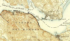
Crockett covers about 1.1 square miles (2.75 square kilometers) of land. It is located where the Carquinez Strait meets San Pablo Bay. The Carquinez Bridge, which is part of Interstate 80, connects Crockett to Vallejo across the strait.
To the east of Crockett are the towns of Port Costa and Martinez. To the south are Rodeo and Hercules. If you travel southwest on I-80, you'll find cities like Richmond and Oakland. Going northeast on I-80 will take you to Sacramento, the capital of California.
Climate
Crockett has a warm-summer Mediterranean climate. This means it has warm, dry summers and mild, wet winters. The average monthly temperatures in summer are not extremely hot.
| Climate data for Crockett, California | |||||||||||||
|---|---|---|---|---|---|---|---|---|---|---|---|---|---|
| Month | Jan | Feb | Mar | Apr | May | Jun | Jul | Aug | Sep | Oct | Nov | Dec | Year |
| Record high °F (°C) | 73 (23) |
79 (26) |
85 (29) |
92 (33) |
100 (38) |
104 (40) |
110 (43) |
103 (39) |
107 (42) |
99 (37) |
87 (31) |
75 (24) |
110 (43) |
| Mean daily maximum °F (°C) | 54.1 (12.3) |
59.6 (15.3) |
63.5 (17.5) |
66.8 (19.3) |
71.1 (21.7) |
77.0 (25.0) |
80.0 (26.7) |
80.3 (26.8) |
78.7 (25.9) |
73.3 (22.9) |
64.3 (17.9) |
54.9 (12.7) |
68.6 (20.3) |
| Daily mean °F (°C) | 47.4 (8.6) |
51.6 (10.9) |
54.6 (12.6) |
57.3 (14.1) |
61.0 (16.1) |
65.8 (18.8) |
67.6 (19.8) |
67.9 (19.9) |
67.1 (19.5) |
62.9 (17.2) |
55.7 (13.2) |
48.5 (9.2) |
59.0 (15.0) |
| Mean daily minimum °F (°C) | 40.8 (4.9) |
43.6 (6.4) |
45.6 (7.6) |
47.6 (8.7) |
50.9 (10.5) |
54.7 (12.6) |
55.2 (12.9) |
55.5 (13.1) |
55.6 (13.1) |
52.5 (11.4) |
47.1 (8.4) |
42.0 (5.6) |
49.3 (9.6) |
| Record low °F (°C) | 19 (−7) |
29 (−2) |
30 (−1) |
34 (1) |
39 (4) |
41 (5) |
46 (8) |
44 (7) |
45 (7) |
38 (3) |
31 (−1) |
21 (−6) |
19 (−7) |
| Average precipitation inches (mm) | 3.55 (90) |
3.10 (79) |
2.31 (59) |
1.37 (35) |
0.38 (9.7) |
0.16 (4.1) |
0.03 (0.76) |
0.04 (1.0) |
0.20 (5.1) |
1.05 (27) |
2.08 (53) |
3.38 (86) |
17.65 (448) |
| Average snowfall inches (cm) | 0.4 (1.0) |
0.0 (0.0) |
0.0 (0.0) |
0.0 (0.0) |
0.0 (0.0) |
0.0 (0.0) |
0.0 (0.0) |
0.0 (0.0) |
0.0 (0.0) |
0.0 (0.0) |
0.0 (0.0) |
0.0 (0.0) |
0.4 (1) |
| Average precipitation days (≥ 0.01 in) | 9 | 9 | 8 | 5 | 2 | 1 | 0 | 0 | 1 | 3 | 6 | 9 | 53 |
| Source: Western Regional Climate Center | |||||||||||||
Arts and Culture
Bailey Art Museum
The Bailey Art Museum in Crockett shows the amazing artwork of Clayton Bailey. He was a famous sculptor who lived nearby. The museum has many of his works from over 50 years. You can see examples of "Funk art," ceramics, and metal sculptures. He even made robots and space guns! There are also strange, pretend-scientific items created by his made-up character, Dr. Gladstone. The museum also displays watercolor drawings by Betty Bailey.
Crockett Historical Society
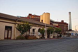
The old Crockett railroad station is now home to the Crockett Historical Society. This group helps preserve the history of the town.
People in Crockett
| Historical population | |||
|---|---|---|---|
| Census | Pop. | %± | |
| 2020 | 3,242 | — | |
| U.S. Decennial Census | |||
In 2010, Crockett had a population of 3,094 people. Most of the people living in Crockett are White. There are also African American, Native American, Asian, and Pacific Islander residents. About 15.8% of the population is Hispanic or Latino.
Economy
Crockett is home to the main office of C&H Sugar. This company is now part of American Sugar Refining.
Crockett also has a large fuel storage facility. It is owned by the NuStar Energy L.P. Corporation. This facility has 24 big tanks that can hold a lot of fuel. Two of these tanks store ethanol, which is mixed with other fuels to make cleaner car fuel for California.
Education
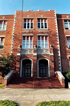
Crockett is part of the John Swett Unified School District. The town has two schools: Carquinez Middle School and John Swett High School. There is also a public library, the Crockett Library, which is part of the Contra Costa County Library system.
Fun and Recreation
Crockett is next to two large regional parks. These parks are managed by the East Bay Regional Park District.
Crockett Hills Regional Park is south of Crockett. It's a big park with hills ranging from 150 to 800 feet high. From here, you can see amazing views of San Pablo Bay and other landmarks. There are trails for hiking and mountain biking, including a part of the Bay Area Ridge Trail.
The Carquinez Strait Regional Shoreline is another park. It has 1,415 acres of bluffs and shoreline along the Carquinez Scenic Drive. This park is between Crockett and Martinez. Both parks offer open grasslands, wooded areas, and views of the water. You can enjoy trails that lead to canyon views and high points.
Notable People
- Dino Waldren (born 1991), a professional rugby player who played for the United States national rugby union team.
See also
 In Spanish: Crockett (California) para niños
 | James Van Der Zee |
 | Alma Thomas |
 | Ellis Wilson |
 | Margaret Taylor-Burroughs |


