Bay Area Ridge Trail facts for kids
Quick facts for kids Bay Area Ridge Trail |
|
|---|---|

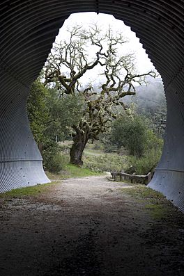
Tunnel to Alpine Pond at Russian Ridge Open Space Preserve
|
|
| Length | 550 mi (890 km) |
| Location | San Francisco Bay Area, United States |
| Use | Hiking, bicycling, horseback riding, birdwatching, environmental education |
| Waymark | Yes, continuous shoreline trail around San Francisco and San Pablo Bays |
The Bay Area Ridge Trail (often called the Ridge Trail) is a super long path planned to be 550-mile (890 km)! It follows the hills and mountains around the San Francisco Bay Area in Northern California. Imagine a giant ring of trails!
Right now, over 380 miles (610 km) of the trail are already built. When it's all done, this amazing trail will connect more than 75 parks and open spaces. It's designed for lots of activities like hiking, running, bicycling, and even horseback riding. You can get onto the trail from places near big cities, but it also reaches into more wild and remote areas. The very first part of the trail opened on May 13, 1989.
Contents
How the Ridge Trail Started
William Penn Mott Jr. was a really important person in the history of parks. He used to be in charge of the National Park Service. In 1987, he gave a speech where he shared his big idea for the Ridge Trail.
Back in the 1960s, when he worked for the East Bay Regional Park District, his office had amazing views from a hilltop in the East Bay. These views made him dream of a trail that would go all around the Bay, connecting different communities. His idea was so good that people from different political groups, like George Miller, supported it.
In May 1987, a group called the Greenbelt Alliance held a meeting. They wanted to find a way to open up more land for public use. At this meeting, Brian O'Neill, who managed the Golden Gate National Recreation Area, suggested a plan. Later that year, a special committee was formed with almost 40 different groups and people. This committee eventually became the Bay Area Ridge Trail Council, which helps make the trail a reality.
In 1999, even before the trail was finished, two retired friends, Dinesh Desai and Bob Cowell, decided to hike the entire planned route! They followed existing trails and even used a kayak to cross the Carquinez Strait where no trail existed yet.
Growing the Trail: Progress Over Time
The first two parts of the Ridge Trail opened on May 13, 1989, in San Mateo County. Many trails that already existed in public parks were added to the Ridge Trail. This helped it grow quickly!
- By 1990, the trail reached 100 miles (160 km).
- By 1995, it was 200 miles (320 km) long.
- In 1999, 217 miles (349 km) were completed, mostly on public lands.
- In 2005, another 10 miles (16 km) were added, including a new bridge over San Geronimo Creek. At this point, the trail was 285 miles (459 km) long.
- When the section through Crockett Hills Regional Park opened in June 2006, the trail passed the 300-mile (480 km) mark!
As of As of 2020[update], the Ridge Trail is 383 miles (616 km) long. The part of the trail that goes through San Francisco is completely finished. Some parts of the San Francisco trail were even changed to go through more green spaces and over Twin Peaks. Large sections in Marin, Contra Costa, and Alameda counties are also done.
Most of the remaining parts of the trail are on private land in Santa Clara, Sonoma, and Napa counties. To finish these sections, the trail organizers might need to buy land or get special agreements to cross it.
Where Does the Ridge Trail Go?
The Ridge Trail starts near the Golden Gate Bridge and goes clockwise around the Bay. It passes through every single Bay Area county! These include Marin, Sonoma, Napa, Solano, Contra Costa, Alameda, Santa Clara, Santa Cruz, San Mateo, and San Francisco counties. The planned trail will go as far north as Calistoga and Angwin, and as far south as Gilroy.
San Francisco's Ridge Trail Spots
If you're exploring the trail in San Francisco, you'll pass through some cool places:
- Lake Merced
- Stern Grove
- Twin Peaks
- Buena Vista Park
- The Panhandle of Golden Gate Park
- The Presidio
| County | Miles Completed | Total Miles Planned |
|---|---|---|
| Marin | 62 miles (100 kilometres) |
72 miles (116 kilometres) |
| Sonoma | 29 miles (47 kilometres) |
50 miles (80 kilometres) |
| Napa | 18 miles (29 kilometres) |
80 miles (130 kilometres) |
| Solano | 30 miles (48 kilometres) |
50 miles (80 kilometres) |
| Contra Costa | 43 miles (69 kilometres) |
49 miles (79 kilometres) |
| Alameda | 36 miles (58 kilometres) |
56 miles (90 kilometres) |
| Santa Clara | 83 miles (134 kilometres) |
190 miles (310 kilometres) |
| San Mateo | 44 miles (71 kilometres) |
65 miles (105 kilometres) |
| San Francisco | 15 miles (24 kilometres) |
20 miles (32 kilometres) |
The Bay Area Ridge Trail Council
The Bay Area Ridge Trail Council (BARTC) is the group that works hard to make the Ridge Trail happen. It was started in 1987 and became a non-profit organization in 1991.
The Council works with local governments, land trusts (groups that protect land), and volunteers in all nine Bay Area counties. Their main goals are to protect open spaces and to plan, build, and promote the Ridge Trail. The Council's office is located in The Presidio in San Francisco.
 | Victor J. Glover |
 | Yvonne Cagle |
 | Jeanette Epps |
 | Bernard A. Harris Jr. |


