
Hercules, California facts for kids
Quick facts for kids
Hercules, California
|
||
|---|---|---|
| City of Hercules | ||

Refugio Valley Park
|
||
|
||
| Motto(s):
"The Dynamic City on the Bay"
|
||

Location of Hercules in Contra Costa County, California
|
||

Hercules, California
Location in the United States
|
||
| Country | United States | |
| State | California | |
| County | Contra Costa | |
| Incorporated | December 15, 1900 | |
| Named for | Hercules Powder Company | |
| Area | ||
| • Total | 19.99 sq mi (51.77 km2) | |
| • Land | 6.41 sq mi (16.61 km2) | |
| • Water | 13.57 sq mi (35.16 km2) 65.87% | |
| Elevation | 79 ft (24 m) | |
| Population
(2010)
|
||
| • Total | 24,060 | |
| • Estimate
(2019)
|
26,276 | |
| • Density | 4,097.30/sq mi (1,582.06/km2) | |
| Time zone | UTC-8 (PST) | |
| • Summer (DST) | UTC-7 (PDT) | |
| ZIP code |
94547
|
|
| Area code(s) | 510, 341 | |
| FIPS code | 06-33308 | |
| GNIS feature IDs | 1658738, 2410746 | |

Hercules is a city in western Contra Costa County, California. It is located along the coast of San Pablo Bay. This area is part of the San Francisco Bay Area, about 10 miles (16 km) north of Berkeley.
In 2020, the city had a population of 26,016 people. Hercules started in 1881 as a factory that made a special type of dynamite called Hercules powder. The company that made it was called the Hercules Powder Company. The small town that grew around the factory became known as "Hercules" and became a city in 1900.
Starting in the 1970s, Hercules changed into a suburb where people live and travel to work in other cities. It is located along the I-80 highway. Hercules is known for its many different cultures and people.
Contents
History of Hercules
Early Times to the 1900s
The first people lived in the Contra Costa County area thousands of years ago. These included the Bay Miwok people and the Huichin Ohlone People. However, there were no big settlements right where Hercules is today.
The land that became Hercules was part of a large area given to Ygnacio Martinez in 1823. He was a commandant at the Presidio of San Francisco. This land later became part of the United States in 1848. Contra Costa County was formed in 1850.
Railroad lines were built across Hercules' waterfront in the late 1870s. These were part of the main route for the Transcontinental Railroad. Another railroad, the Atchison, Topeka and Santa Fe Railroad, came through around 1899.
The city's history is mostly shaped by the Hercules Powder Company. This company was named after its main product, "Hercules powder," which was a special type of dynamite. The company started as the California Powder Works. They had to move from San Francisco because making explosives was dangerous.
Hercules was a good choice for the new plant because it was isolated. It was also close to trains and water transportation along San Pablo Bay. The new plant opened in 1881. On December 15, 1900, the town became an official city. A post office opened in 1914.

Making explosives was very risky back then. In the first 38 years, 59 people died at the Hercules plant. This included 24 people in a big explosion in 1908. More deadly explosions happened later in 1944, 1948, and 1953.
The explosives made in Hercules were very important. They helped the United States Army put out fires after the 1906 San Francisco earthquake.
Between the 1890s and 1970s, Hercules was a "company town." This meant most people who lived there worked for the Hercules Powder Company. The town had nice homes, a clubhouse, tennis courts, and a hospital. However, Chinese workers, who were a big part of the company's workforce, were not allowed to live in the town's main homes. They lived in special dorms.
By 1917, the Hercules plant was the biggest producer of TNT in the country. During both World Wars, Hercules Powder Company supplied explosives to the U.S. Navy. The company also had its own law enforcement department.
After World War II, the company started making other products, like fertilizer. They stopped making explosives in Hercules in 1964. In 1974, the land that was used as a safety "buffer" around the explosives plant could be used for other things.
Starting in 1974, real estate development companies began building homes. Hercules then started to become the bedroom community it is today. The fertilizer plant closed in 1976. Even though the Hercules Powder Company is gone, studies have been done to check for soil pollution from its past operations.
In 1966, the Pacific Refinery company started operating in Hercules. It was a major employer until it closed in 1995. This marked the end of heavy industry in Hercules after 114 years. The land where the refinery was located is now a neighborhood called Victoria by the Bay. Biorad, a large biotech company, set up its headquarters in Hercules in the 1980s. It is still the city's biggest employer.
Since the 1970s, Hercules has planned how it wants to grow. It was one of the first cities in the United States to create a plan to control noise. This included maps of noise levels from highways and roads. The city continued to grow rapidly as a suburb through the 1980s and beyond.
The town's population grew very fast in the late 1900s. In 1970, only 252 people lived there. By 1980, it had grown to 5,963 people. By 1990, the population was 16,829. By 2000, it reached about 25,000 people.
Recent Changes and Growth

In 2000, Hercules started a new plan for how the city would use its land. This plan aimed to protect undeveloped land and stop suburban sprawl. It also wanted to redevelop the city's old industrial waterfront. The plan aimed to make Hercules a place where people could easily walk and use public transport. It also planned for mixed-use buildings (homes and shops together).
Several new developments began based on this plan. These included the Central Waterfront and Victoria by the Bay. However, developing Hercules has had its challenges.
In 2006, Hercules strongly opposed Walmart's plan to build a large store. Many residents felt it didn't fit with the waterfront redevelopment. They also thought it wasn't needed because there were other Walmarts nearby. The city council voted to stop Walmart from building the store. In 2009, the city bought the land back from Walmart.
In 2012, an audit found that the city had spent a lot of money on "questionable transactions." This nearly caused the city to go bankrupt during the Great recession. Later, new developments helped the city improve its financial situation.
Geography and Climate
Location and Surroundings
Hercules is located at 38°01′02″N 122°17′19″W / 38.01722°N 122.28861°W. It is on the southeast shore of San Pablo Bay. The city covers about 18.2 square miles (47.1 km2). About 6.2 square miles (16.1 km2) is land, and 12.0 square miles (31.1 km2) is water.
Hercules is about 4 miles (6.4 km) southwest of the Carquinez Bridge. By road, it is about 12 miles (19 km) north of Berkeley, California, and 22 miles (35 km) northeast of San Francisco. Refugio Creek flows through the middle of Hercules and into the bay.
The city is divided by Interstate 80. This highway runs about one mile inland from the coast. I-80 is the main road between San Francisco and Sacramento. It connects with California State Route 4 in Hercules. Other important roads include San Pablo Road and Refugio Valley Road.
City Layout

Hercules mostly looks like a suburb. It has many two-story homes and one-story shops. These are divided into different neighborhoods with well-kept roads. The waterfront area is planned for more dense development. This includes shops and mixed-use buildings that are 3 to 5 stories tall.
The area inland from Highway 80 has gently rolling hills. Most of the suburbs here were built in the 1970s and 1980s. These neighborhoods have fun names like “the Birds,” “the Trees and Flowers,” “the Gemstones,” “the Astronauts,” and “the Islands.” The area near the shoreline has newer developments. These include the Waterfront, Olympian Hills, Hercules by the Bay, Village Park, and Victoria by the Bay.
Weather in Hercules
Hercules has a mild Mediterranean climate. This is typical for much of the northern San Francisco Bay Area. Because Hercules is more inland, it is usually warmer than towns closer to the Golden Gate.
The average rainfall is 23.35 inches (593 mm) per year. Most of this rain falls from November to March. The average high temperature in July is 71 degrees Fahrenheit (22 degrees Celsius). The average low temperature in January is 43 degrees Fahrenheit (6 degrees Celsius).
| Climate data for Hercules, California | |||||||||||||
|---|---|---|---|---|---|---|---|---|---|---|---|---|---|
| Month | Jan | Feb | Mar | Apr | May | Jun | Jul | Aug | Sep | Oct | Nov | Dec | Year |
| Record high °F (°C) | 76 (24) |
88 (31) |
85 (29) |
94 (34) |
100 (38) |
106 (41) |
98 (37) |
98 (37) |
107 (42) |
100 (38) |
86 (30) |
83 (28) |
106 (41) |
| Mean daily maximum °F (°C) | 57 (14) |
61 (16) |
63 (17) |
66 (19) |
68 (20) |
71 (22) |
70 (21) |
71 (22) |
73 (23) |
72 (22) |
64 (18) |
57 (14) |
66 (19) |
| Mean daily minimum °F (°C) | 43 (6) |
45 (7) |
47 (8) |
48 (9) |
51 (11) |
54 (12) |
55 (13) |
56 (13) |
56 (13) |
53 (12) |
48 (9) |
43 (6) |
50 (10) |
| Record low °F (°C) | 27 (−3) |
28 (−2) |
33 (1) |
31 (−1) |
38 (3) |
43 (6) |
44 (7) |
44 (7) |
46 (8) |
41 (5) |
34 (1) |
24 (−4) |
24 (−4) |
| Average rainfall inches (mm) | 4.91 (125) |
4.41 (112) |
3.52 (89) |
1.35 (34) |
0.54 (14) |
0.17 (4.3) |
0.07 (1.8) |
0.09 (2.3) |
0.27 (6.9) |
1.25 (32) |
3.47 (88) |
3.30 (84) |
23.35 (593.3) |

Parks and Fun Activities
Hercules has over 98 acres (40 hectares) of parkland in six parks. The main park is Refugio Valley Park. The city also has over 950 additional acres (380 hectares) of open space.
Hercules is close to several nature preserves. These include Point Pinole Regional Shoreline and Crockett Hills Regional Park. Franklin Canyon Golf Course is an 18-hole golf course on the east side of the city. The San Francisco Bay Trail runs along Hercules' waterfront. The cities of Oakland and San Francisco are also nearby. Wine Country (like Napa and Sonoma) is about a half-hour drive north.
People and Community
Different Cultures and Backgrounds
Hercules has a very diverse population. In 2015, about 45.5% of the people were Asian, 22% were White, 18.9% were Black, and 14.6% were Hispanic. About 32% of the people living in Hercules were born in another country.

Money, Jobs, and Education
In 2014, the average household income in Hercules was $101,018. This means many families in Hercules are considered "upper middle class." About 42.7% of Hercules residents have a college education. Many people work in management, business, and arts jobs (46%). Others work in sales and office jobs (27.2%) or service jobs (14.3%).
| Historical population | |||
|---|---|---|---|
| Census | Pop. | %± | |
| 1910 | 279 | — | |
| 1920 | 373 | 33.7% | |
| 1930 | 392 | 5.1% | |
| 1940 | 343 | −12.5% | |
| 1950 | 343 | 0.0% | |
| 1960 | 310 | −9.6% | |
| 1970 | 252 | −18.7% | |
| 1980 | 5,963 | 2,266.3% | |
| 1990 | 16,829 | 182.2% | |
| 2000 | 19,488 | 15.8% | |
| 2010 | 24,060 | 23.5% | |
| 2020 | 26,016 | 8.1% | |
| U.S. Decennial Census | |||
2010 Census Information
The 2010 Census showed that Hercules had 24,060 people. Most people (99.8%) lived in homes. The city had 8,115 households. About 39.1% of these households had children under 18. The average household had 2.96 people.
The population included:
- 22.0% White
- 18.9% African American
- 0.4% Native American
- 45.5% Asian
- 0.4% Pacific Islander
- 6.5% from other races
- 6.2% from two or more races
- 14.6% were Hispanic or Latino (of any race)
About 22.8% of the population was under 18 years old. The median age was 39.0 years. Most homes (79.5%) were owned by the people living in them.
Economy and Jobs
Hercules' Main Businesses
Hercules is mostly a suburban community. However, it is also home to the headquarters of Bio-Rad, a large biotech company. In 2017, Bio-Rad had 7,800 employees worldwide. The company is located in the North Shore Business Park. Hercules also has shopping centers with stores and offices.
Top Employers in Hercules
Here are the top 10 employers in Hercules, based on a 2020 report:
| # | Employer | # of employees |
|---|---|---|
| 1 | Bio-Rad Laboratories | 2,271 |
| 2 | West Contra Costa Unified School District | 238 |
| 3 | Home Depot | 198 |
| 4 | Contra Costa County Social Services | 106 |
| 5 | Lucky Supermarkets | 100 |
| 6 | Pacific Bio Labs Inc | 94 |
| 7 | City of Hercules | 60 |
| 8 | Kinder's Meats & Deli BBQ & Catering | 40 |
| 9 | Benda Tool & Model Works Inc | 36 |
| 10 | Big Lots | 25 |
Education and Learning
Public Schools in Hercules
Hercules has two school districts. The West Contra Costa Unified School District serves most of the city. The John Swett Unified School District serves the Foxboro area.
- Hercules Middle/High School is the main middle and high school.
- Hanna Ranch Elementary serves the Trees and Mandalay areas.
- Ohlone Elementary serves the Birds, Gems, and Hercules Avenue areas.
- Lupine Elementary serves the Trees and Flowers areas.

Public Libraries
The Contra Costa County Library System runs the Hercules Public Library.
Transportation and Travel
Hercules is located where I-80 and State Route 4 meet. I-80 is the main highway between San Francisco and Sacramento. Highway 4 connects to I-680, which leads to Concord, California, Walnut Creek, California, and the Tri-Valley Area. In 2015, about 90% of people in Hercules drove to work. The average commute time was 39 minutes.
Public transportation is available through the WestCat bus system. WestCat buses travel throughout Hercules and to nearby cities like Rodeo, Pinole, and Richmond. WestCat also has express buses to Martinez, the El Cerrito del Norte BART station, and the San Francisco Transbay Terminal. The main bus hub is Hercules Transit Center.
The closest international airports are Oakland International Airport (29 miles/47 km away) and San Francisco International Airport (35 miles/56 km away).
Train lines from the Southern Pacific and the Burlington Northern railroads pass through Hercules. A new Hercules station is planned for the Capitol Corridor train line. There are also plans for a San Francisco Bay Ferry Service from the same station to San Francisco.
Sister City
Hercules has a sister city in Japan. It is Tsushima, in Aichi Prefecture.
Famous People from Hercules
- Willie McGee, a former baseball player for the St. Louis Cardinals and San Francisco Giants.
- Claudell Washington, a former baseball player for MLB.
Images for kids
-
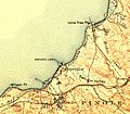
Excerpt from the 1916 USGS map centered on Hercules. The town was near the plant at the waterfront.

See also
 In Spanish: Hercules (California) para niños
