
Urban sprawl facts for kids

Urban sprawl happens when a city grows outwards into areas that used to be empty. This growth often happens without careful urban planning. In the past, living inside a city meant you were protected. Today, that's not the case, and the main downside is that it takes longer to get to the city center. People often disagree on exactly what urban sprawl means and how to measure it.
The term "urban sprawl" is often used in a negative way. It usually suggests that a city is growing in an uncontrolled manner.
What is Urban Sprawl?

Urban sprawl has several key features that make it easy to spot. These features show how cities are spreading out and changing the land around them.
Different Areas for Different Uses
Imagine a town where all the shops are in one place, all the houses in another, and all the offices somewhere else. This is called "single-use development." It means that areas for homes, shops, and businesses are kept separate. Because of this, you often need a car to go from where you live to where you work or shop. Walking or biking becomes difficult. How much these different areas are mixed together is a common way to measure sprawl.
Jobs Moving Out of the City

"Job sprawl" means that most jobs in a big city area are no longer in the main city center. Instead, they are moving to the suburbs. Companies often like to set up in these areas because land is cheaper. There is also more room to grow their business later.
This can create a problem called "spatial mismatch." It means that people living in the city, especially those who are poor, might find it hard to get to these new jobs. They might not have good transportation to travel to the suburbs.
Spread-Out Homes

Sprawl often means homes are built far apart, not close together. This is called "low-density development." Think of Single-family homes on big lots, with lots of space between them. These homes usually have fewer floors and are separated by lawns, gardens, roads, or parking lots.
In the United States, having 2 to 4 houses per acre (about 5 to 10 per hectare) is seen as low-density. In the UK, 8 to 12 houses per acre (20 to 30 per hectare) is still considered low-density. Because people in the USA use cars more, a lot of land is used for parking. This means that developed land is growing faster than the population.
Sometimes, new neighborhoods are built far from the main city, jumping over empty land. This is called "leapfrog development." These developments are often separated by large areas of undeveloped land, like green belts. This makes the overall area even less dense.
Farmland Turning into City Land
Land for urban sprawl often comes from good agricultural lands. Modern sprawl has used up a lot of the best farmland. It has also taken over forests, deserts, and other wild areas.
New Housing Areas

"Housing subdivisions" are large areas of land filled only with newly built homes. These areas often have winding roads and cul-de-sacs (dead-end streets). They might have only a few ways to enter or leave, which can make traffic heavy on the main roads. Every trip, even a short one, often requires using these main roads.
Lots of Lawns
After World War II, having a large lawn became very common in suburban homes, especially in North America. The growth of golf courses also made lawns more popular. Now, lawns take up a lot of land in new housing areas, adding to urban sprawl.
Shopping and Business Areas

In sprawling areas, businesses are usually separate from homes. In the U.S. and Canada, you often see "strip malls." These are groups of stores that share a big parking lot, usually along a busy road. In the UK, similar places are called Retail Parks. Strip malls with very large stores are sometimes called "power centers." These places are also low-density, with single-story buildings and lots of space for parking.

Another common type of business area in sprawling places is the shopping mall. Unlike a strip mall, this is usually one big building with many shops inside, surrounded by a huge parking lot. Shopping malls are mostly for fun shopping, not for daily needs. They often serve a larger area and need good access to highways.
Fast food restaurants are often built early in new areas where land is cheap and many people are expected to move. They can set the style for future development with their big parking lots and bright signs. Some people believe that fast food chains make suburban sprawl happen faster. They also think that this creates a cycle where people keep moving away from sprawl, only to create more of it.
How Sprawl Affects Us

Urban sprawl has several negative effects on our environment and our lives.
Impact on Nature
One big problem with sprawl is the loss of land and animal habitats. This leads to fewer different kinds of plants and animals, which is called a reduction in biodiversity. Studies show that cities growing outwards threaten more species than almost any other human activity. Urban sprawl can harm native plants and animals and bring in new, unwanted plants. Even with careful planning, sprawl is a major threat to nature.
Other environmental problems include:
- More flooding: This happens because more land is covered by roads and parking lots, which don't absorb water.
- Higher temperatures: Sprawl can create "heat islands," where city areas are much hotter than the countryside. This can be dangerous for older people.

Sprawl also increases water pollution. Rainwater picks up things like gasoline, motor oil, and heavy metals from parking lots and roads. This dirty water then runs into rivers and lakes.

Health Effects
Sprawl means people drive more cars. More cars mean more pollution in the air, which is bad for our health. Also, driving more means less physical activity, which is not good for our bodies. Studies have found a strong link between sprawl and health problems like obesity (being very overweight) and hypertension (high blood pressure). Loud vehicles can also cause stress and make it harder to sleep.
Sprawl also makes it less likely that people will ride a bicycle for their daily travel. Riding a bike is good for your health because it's a form of exercise. When you ride a bike to work, you are exercising at the same time, which is better than just sitting in a car.
Safety Concerns
When people rely heavily on cars, there's more traffic in cities. This leads to more car crashes and injuries for people walking or biking. Car crashes are a leading cause of death for young people. People in sprawling areas are generally more likely to die in a car crash because they spend more time driving. Pedestrians in sprawling areas also face higher risks.
Research also shows that sprawl can cause delays for emergency services, like ambulances and fire trucks.
Economic Costs


Living in spread-out areas generally makes public services more expensive. Since most people use cars, and public transport becomes more costly, cities have to build more highways and parking lots. This takes up land that could be used for other things and reduces the money the city can collect in taxes. Providing services like water, sewers, road repairs, and electricity is also more expensive per home in less dense areas. This is because power lines, roads, and pipes have to be much longer, leading to higher maintenance costs.
People living in low-density areas also spend a bigger part of their income on transportation compared to those in high-density areas.

Social Impact
Urban sprawl might be partly responsible for less community feeling in places like the United States. In compact neighborhoods, people often meet and talk to their neighbors by chance. Sprawl, however, can create barriers between people. It tends to replace shared public spaces with private ones, like fenced-in backyards.
Some studies have looked at how population density affects people's behavior. While some people used to think that higher density led to more crime or aggressive behavior, this idea has largely been disproven.
Images for kids
-
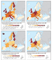
Measures for urban sprawl in Europe: upper left shows the Dispersion of the built-up area (DIS), upper right shows the weighted urban proliferation (WUP).
-
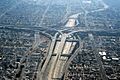
Many people in California live, travel, and work within the huge network of Southern California freeways.
-
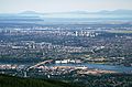
Many Canadian cities have areas of high density even in their distant suburbs. Some Canadian suburbs have skylines that look like big American cities. This picture shows Burnaby, British Columbia, a suburb of Vancouver.


See also
 In Spanish: Dispersión urbana para niños
