
Southern California freeways facts for kids
A huge network of connected roads called freeways helps over 23 million people get around in Southern California. This area is so big it's sometimes called a "megaregion." The main plan for these freeways in Los Angeles was approved in 1947. Building started in the early 1950s. However, the plan faced problems and money issues in the 1970s. By 2004, only about 61% of the planned roads were finished.
Contents
How Southern California's Freeways Started
Why Cars Became Popular
Southern California's love for cars began partly because people didn't like how much control the Southern Pacific Railroad had over business in the late 1800s and early 1900s. In 1910, a politician named Hiram Johnson ran for governor. He was against the railroad. He traveled the state by car, which was a big deal back then! This made people in Southern California connect cars with good, honest government. It was a big change from the railroads, which many saw as controlling unfair governments in other parts of the U.S.
Even though the Pacific Electric Railway (owned by Southern Pacific) had famous "Red Car" streetcar lines, they weren't making much money. Cars became cheaper in the 1920s, and more people bought them. This meant fewer people rode the Red Cars. Soon, traffic jams became a huge problem. At the same time, many city planners thought building "Magic Motorways" (freeways) would help cities grow. They wanted cities to spread out with cars as the main way to travel. This would help with crowded cities and make it easier for people to own homes.
By the late 1930s, traffic in Los Angeles was a very big worry. The Automobile Club of Southern California created a detailed plan for an elevated freeway system. A key part of this plan was getting rid of the streetcar lines. Buses would replace them, running on both local streets and the new express roads. When city planners first designed the freeway system in the 1930s, they wanted to put light rail tracks in the middle of each freeway. These tracks would have been for the Pacific Electric Railway's Red Cars. But this part of the plan was never fully built.
Planning and Building the Roads
During World War II, it became clear that Southern California's roads and railways couldn't handle a large population. Many people believed the region needed a completely new transportation system. Los Angeles city leaders wanted to improve the rail system, focusing on the city center. However, the Arroyo Seco Parkway, built between Los Angeles and Pasadena in 1940, was a big success. It convinced many that a freeway system could solve the region's traffic problems.
Leaders from nearby cities like Whittier, South Gate, Long Beach, and Pasadena wanted a network of freeways to connect the whole region. They didn't want all traffic to go through downtown Los Angeles. The idea of building freeways won out. By 1947, a new, complete freeway plan for Los Angeles was ready. This plan was similar to the 1930s idea but without the light rail tracks. Caltrans (then called the California Department of Public Works) created this plan. San Diego soon made its own plan, and by the early 1950s, construction on many of the region's freeways had begun.
Future Freeway Plans
Caltrans and local transportation groups have identified these important freeway projects for the future:
- A toll road that will go through a tunnel in the Santa Ana Mountains, connecting Irvine to Corona.
- Upgrading State Route 210 to Interstate standards. It would then be called Interstate 210.
- A new freeway, the Mid County Parkway, from Interstate 215 in Perris to State Route 79 in San Jacinto.
- An extension for Interstate 710, the Long Beach Freeway. It would reach its original planned end at Interstate 210 in Pasadena. This would likely involve a tunnel under South Pasadena. However, Caltrans stopped this project in November 2018.
- An extension to the State Route 241 toll road to meet Interstate 5 in or near San Clemente.
- Upgrading State Route 71, the Chino Valley Freeway. This would make it a full controlled-access freeway north of State Route 60 (the Pomona Freeway) to Interstate 10 (the San Bernardino Freeway) in Pomona.
- Upgrading State Route 55, the Costa Mesa Freeway. This would extend it south from its current end at 19th Street in Costa Mesa to State Route 1 (the Pacific Coast Highway) in Newport Beach. This might happen through a tunnel.
- Building the High Desert Corridor. This would be a freeway and expressway between State Route 14 (the Antelope Valley Freeway) in Palmdale and Interstate 15 (the Mojave Freeway) near Victorville. It would also have a high-speed rail line to Las Vegas, Nevada. Caltrans put the freeway part on hold in 2019.
How Freeways Are Named
Freeway Names and Numbers
People in Southern California often talk about freeways using "the" before the number, like "the 5" or "the 10." This is different from how people in Northern California talk about them. It's more like how people in the UK say "the M1."
Also, parts of the Southern California freeway system are often called by names instead of just their official numbers. For example, parts of Interstate 10 are called the Santa Monica Freeway or the San Bernardino Freeway. Even though signs now mostly show the highway number, direction, and a city name, people still use the old names. A freeway "name" can even refer to parts of two or more different numbered roads. For example, the Ventura Freeway includes parts of U.S. Route 101 and State Route 134. The San Diego Freeway includes parts of Interstate 5 and all of Interstate 405.
When Southern California freeways were first built in the 1940s and early 1950s, people mostly used the freeway names with "the" in front. It took many years for people to start using the numbers too, but "the" stayed. For example, the San Gabriel River Freeway became "the 605 Freeway," and then just "the 605."
Famous Freeway Interchanges
Here are some well-known freeway connections in Southern California:
- Four Level: Where US 101 meets SR 110.
- East Los Angeles: A big connection for I-5, I-10, SR 60, and US 101.
- Judge Harry Pregerson: Where I-105 meets I-110.
- El Toro Y: The southern meeting point of I-5 and I-405.
- Orange Crush: Where I-5, SR 22, and SR 57 all connect.
- Newhall Pass: Where I-5 meets SR 14.
Other Important Freeway Spots
- Downtown Slot: The part of Highway 101 that goes through a trench in downtown Los Angeles.
- South Bay Curve: Where Interstate 405 changes direction from north-south to east-west in Torrance.
- Sepulveda Pass: A section of Interstate 405 near the J. Paul Getty Museum.
- Cahuenga Pass: The Hollywood Freeway just south of where it connects with the Ventura Freeway.
- Figueroa Street Tunnels: Tunnels on the northbound lanes of the Pasadena Freeway.
Freeway Firsts and Facts
Southern California has some notable "firsts" in freeway history:
- The Arroyo Seco Parkway was the first freeway in California. It connected Pasadena and Los Angeles.
- The Four Level Interchange in downtown Los Angeles was the first stack interchange ever built.
- It had the first special lanes for cars with multiple passengers (HOV lanes) that were separated from other traffic.
- The 91 Express Lanes in Orange County were the first fully automated toll road system.
Compared to other big cities in the United States, Southern California has fewer lane-miles of freeway per person. In 1999, Greater Los Angeles had 0.419 lane-miles for every 1,000 people. This was less than places like Greater Boston and the Washington Metropolitan Area. The average for American cities was 0.613 lane-miles per thousand people.
Roads Not Maintained by the State
Some roads that act like freeways are not kept up by the state government. These include:
- Colorado Street in Glendale.
- Colorado Freeway in Eagle Rock.
- Harbor Scenic Drive in Long Beach, leading to the Queen Mary.
- Jamboree Road in Irvine.
- Oak Grove Drive in Pasadena.
- Shoreline Drive in Long Beach.
- La Cienega Boulevard in the Baldwin Hills.
- Los Patrones Parkway in Las Flores.
List of Freeways
Main Freeways In and Out of Southern California
 Interstate 5: Goes from the U.S.-Mexico border in San Ysidro north through the Central Valley.
- John J. Montgomery Freeway: From the border to downtown San Diego.
- San Diego Freeway: From downtown San Diego to the El Toro Y.
- Santa Ana Freeway: From the El Toro Y to the East L.A. Interchange.
- Golden State Freeway: From the East L.A. Interchange to Wheeler Ridge.
 Interstate 8: Goes from Ocean Beach in San Diego east to the Arizona border.
- Ocean Beach Freeway: From Ocean Beach to Old Town.
- Mission Valley Freeway: From Old Town to El Cajon.
 Interstate 10: Goes from Santa Monica east to the Arizona border.
- Santa Monica Freeway: From Santa Monica to the East L.A. Interchange.
- San Bernardino Freeway: From the East L.A. Interchange to San Bernardino.
 Interstate 15: Goes from San Diego north to the Nevada border, towards Las Vegas.
- Escondido Freeway: From San Diego to Interstate 805.
- Mojave Freeway: From San Bernardino to the Nevada border.
 Interstate 40: Goes from Barstow east to the Arizona border.
- Needles Freeway.
 U.S. Route 101: Goes from the East L.A. Interchange west to Santa Barbara, then north towards San Francisco.
- Santa Ana Freeway: From the East L.A. Interchange to the Four Level Interchange.
- Hollywood Freeway: From the Four Level Interchange to the Ventura Freeway.
- Ventura Freeway: From the Hollywood Freeway connection to Seacliff.
 State Route 14: Goes from Interstate 5 in Los Angeles north to U.S. Route 395.
- Antelope Valley Freeway: From Tunnel Station to Mojave.
San Diego Area Freeways
- Interstate 5
- John J. Montgomery Freeway: From the U.S.-Mexico border to downtown San Diego.
- San Diego Freeway: From downtown San Diego to the El Toro Y in Orange County.
- Interstate 8
- Ocean Beach Freeway: From Ocean Beach to Old Town San Diego.
- Mission Valley Freeway: From Old Town San Diego to El Cajon.
-
 Interstate 15 and State Route 15
- Escondido Freeway: From Barrio Logan to Escondido.
 State Route 52
 State Route 54
- South Bay Freeway: From National City to the Jamacha Road exit.
 State Route 56
- Ted Williams Freeway: From Carmel Valley to Sabre Springs.
 State Route 67
 State Route 75
 State Route 78
 State Route 94
- Martin Luther King Jr. Freeway: From downtown San Diego to Spring Valley.
 State Route 125
- South Bay Expressway: From Otay Mesa to the Jamacha Road exit.
 State Route 163
- Cabrillo Freeway: From downtown San Diego to Kearny Mesa.
 Interstate 805
- Jacob Dekema Freeway: From San Ysidro to "The Merge" at Sorrento Valley.
 State Route 905
- Otay Mesa Freeway: From San Ysidro to the Otay Mesa border crossing.
Inland Empire Freeways
(This area includes San Bernardino and Riverside Counties)
- Interstate 10
- San Bernardino Freeway: From the East L.A. Interchange to San Bernardino.
- Interstate 15
- Temecula Valley Freeway: From the San Diego County line to Lake Elsinore.
- Corona Freeway: From Lake Elsinore to Corona.
- Ontario Freeway: From Corona to San Bernardino.
- Mojave Freeway: From San Bernardino to the Nevada State Line.
- Interstate 40
 State Route 60
- Pomona Freeway: From the East L.A. Interchange to Riverside.
- Moreno Valley Freeway: From Riverside to the connection with Interstate 10.
 State Route 71
- Chino Valley Freeway: From just north of State Route 91 to State Route 57.
 State Route 91

 Interstate 210 and State Route 210
- Foothill Freeway: From Sylmar to Redlands.
 Interstate 215
- Escondido Freeway: From Murrieta to Riverside.
- Riverside Freeway: From Riverside to San Bernardino.
- Barstow Freeway: From San Bernardino to the northern connection with Interstate 15.
Greater Los Angeles Area Freeways
(This includes Los Angeles, Orange, Riverside, San Bernardino, and Ventura Counties)
 State Route 1
- Freeway stub in Dana Point.
- Santa Monica Freeway: From Pacific Coast Highway in Santa Monica to Interstate 10.
 State Route 2
- Glendale Freeway: From Silver Lake to Glendale.
- Frank D. Lanterman Freeway: From Glendale to La Cañada-Flintridge.
- Interstate 5
- San Diego Freeway: From San Diego to the El Toro Y.
- Santa Ana Freeway: From the El Toro Y to the East L.A. Interchange.
- Golden State Freeway: From the East L.A. Interchange to Wheeler Ridge.
- Interstate 10
- Santa Monica Freeway: From Santa Monica to the East L.A. Interchange.
- San Bernardino Freeway: From the East L.A. Interchange to San Bernardino.
- State Route 14
- Antelope Valley Freeway: From Tunnel Station to Mojave.
- Interstate 15
- Temecula Valley Freeway: From the San Diego County line to Lake Elsinore.
- Corona Freeway: From Lake Elsinore to Corona.
- Ontario Freeway: From Corona to San Bernardino.
- Mojave Freeway: From San Bernardino to the Nevada State Line.
 State Route 22
- 7th Street freeway stub: From Long Beach to Seal Beach.
- Garden Grove Freeway: From Westminster to Orange.
 State Route 23
- Moorpark Freeway: From Thousand Oaks to Moorpark.
 State Route 33
- Ojai Freeway: From Ventura to Foster Park.
- Interstate 40
 State Route 47
- Vincent Thomas Bridge: Connecting San Pedro to Terminal Island.
- Terminal Island Freeway: From Seaside Avenue to Henry Ford Avenue exit.
 State Route 55
- Newport Boulevard freeway stub: North from State Route 1 in Newport Beach.
- Costa Mesa Freeway: From Costa Mesa to Anaheim.
 State Route 57
- Orange Freeway: From the Orange Crush interchange to Glendora.
 State Route 58
- Freeway stubs near Keene, North Edwards, and Hinkley.
- State Route 60
- Pomona Freeway: From the East L.A. Interchange to Riverside.
- Moreno Valley Freeway: From Riverside to the connection with Interstate 10.
- State Route 71
- Chino Valley Freeway: From just north of State Route 91 to State Route 57.
 State Route 73
- Corona del Mar Freeway: From Costa Mesa to Irvine.
- San Joaquin Hills Transportation Corridor: From Irvine to Laguna Niguel.
 State Route 90
- Marina Freeway freeway stub: East and west of Interstate 405 near Marina del Rey.
- Richard M. Nixon Parkway freeway stub: West from State Route 91 in Yorba Linda.
- State Route 91
- Gardena Freeway: From Interstate 110 in Gardena to Interstate 710 in Long Beach.
- Artesia Freeway: From Interstate 710 in Long Beach to Fullerton.
- Riverside Freeway: From Fullerton to Riverside.
- U.S. Route 101
- Santa Ana Freeway: From the East L.A. Interchange to the Four Level Interchange.
- Hollywood Freeway: From the Four Level Interchange to the connection with State Route 134 and State Route 170.
- Ventura Freeway: From the connection with State Route 134 and State Route 170 to Seacliff.
 State Route 103
- Terminal Island Freeway: Co-signed with State Route 47 to Sepulveda Boulevard.
 Interstate 105
- Glenn Anderson Freeway, also known as the Century Freeway: From El Segundo to Norwalk.
 Interstate 110
- Harbor Freeway: From San Pedro to Downtown L.A.
 State Route 110
- Harbor Freeway: From the connection with the Santa Monica Freeway to the Four Level Interchange.
- Pasadena Freeway: From the Four Level Interchange to Pasadena.
 State Route 118
- Ronald Reagan Freeway, also known as the Simi Valley-San Fernando Valley Freeway: From Moorpark to San Fernando.
 State Route 133
- Laguna Freeway: From just south of Interstate 405 to Interstate 5.
- Eastern Transportation Corridor: From Interstate 5 to State Route 241.
 State Route 134
- Ventura Freeway: From Pasadena to North Hollywood.
 State Route 138
- Lancaster Freeway freeway stub: East from Interstate 5 near Gorman.
 State Route 170
- Hollywood Freeway: From the connection with the Ventura Freeway to the Golden State Freeway.
- Interstate 210 and State Route 210
- Foothill Freeway: From Tunnel Station to Redlands.
- Interstate 215
- Escondido Freeway: From Murrieta to Riverside.
- Riverside Freeway: From Riverside to San Bernardino.
- Barstow Freeway: From San Bernardino to the northern connection with Interstate 15.
 State Route 241
- Foothill Transportation Corridor: From Oso Parkway to the Eastern Transportation Corridor.
- Eastern Transportation Corridor: From the Foothill Transportation Corridor to the Riverside Freeway.
 State Route 261
- Eastern Transportation Corridor: From Jamboree Road to State Route 241.
 Interstate 405
- San Diego Freeway: From the El Toro Y to San Fernando.
 Interstate 605
- San Gabriel River Freeway: From Seal Beach to Duarte.
 Interstate 710
- Long Beach Freeway: From Long Beach to Alhambra.
Images for kids
-
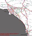
Interstate and State Highway System of Southern California
-
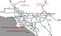
Metropolitan Los Angeles Freeway System and Metropolitan Inland Empire


