
Interstate 110 and State Route 110 (California) facts for kids
Quick facts for kids
[[File:|x70px|alt= marker]] |
||||
|---|---|---|---|---|
| Harbor Freeway | ||||
| Lua error in Module:Infobox_road/map at line 15: attempt to index field 'wikibase' (a nil value).
I-110 and SR 110 highlighted in red
|
||||
| Route information | ||||
| Defined by S&HC § 410 | ||||
| Maintained by Caltrans | ||||
| Length | 31.82 mi (51.21 km) | |||
| Component highways |
|
|||
| Tourist routes |
||||
| Restrictions | No trucks over 3 tons north of exit 24A | |||
| Major junctions | ||||
| South end | ||||
|
||||
| North end | Glenarm Street in Pasadena | |||
| Location | ||||
| Counties: | Los Angeles | |||
| Highway system | ||||
| State highways in California(list • pre-1964) History • Unconstructed • Deleted • Freeway • Scenic
|
||||
The Interstate 110 (often called I-110) and State Route 110 (or SR 110) are two important freeways in Los Angeles County, California. They are connected and help people travel between the Port of Los Angeles and Pasadena. These roads also go right through Downtown Los Angeles.
The part of the road from the Port of Los Angeles up to Interstate 10 is known as I-110. After that, from Interstate 10 to Pasadena, it becomes SR 110. The entire route is also famously called the Harbor Freeway. This busy route stretches for about 32 miles (51 kilometers).
Contents
What is the Harbor Freeway?
The Harbor Freeway is a major road system in Los Angeles. It includes both Interstate 110 and State Route 110. This freeway helps connect many parts of Los Angeles County. It is a very important route for daily commuters and for moving goods from the port.
Why are there two different names?
The freeway has two names because different parts of it are managed differently. The southern part, I-110, is part of the national Interstate Highway System. This system connects states across the U.S. The northern part, SR 110, is a state route, managed by California. Even with two names, most people call the whole road the Harbor Freeway.
Connecting Key Areas in Los Angeles
The Harbor Freeway plays a big role in connecting important places. It links the busy Port of Los Angeles to the heart of Downtown Los Angeles. From there, it continues north to the city of Pasadena. This makes it a vital route for both people and businesses in the region.
Traveling on the Harbor Freeway
The Harbor Freeway is known for being very busy, especially during rush hour. It has many exits that lead to different parts of Los Angeles. The freeway also has special lanes called Express Lanes. These lanes help drivers get through traffic faster, sometimes for a fee.
Important Interchanges and Exits
Along its path, the Harbor Freeway connects with several other major freeways. These connections are called interchanges. For example, it meets I-405 (the San Diego Freeway) and I-105 (the Glenn Anderson Freeway). It also connects with Interstate 10 (the Santa Monica Freeway) and Interstate 5 (the Golden State Freeway). These connections help drivers reach many different destinations.
The Arroyo Seco Parkway
The northern part of SR 110 is also known as the Arroyo Seco Parkway. This section is special because it's one of California's first freeways. It has a historic feel with older designs and tighter curves than modern freeways. It's a scenic route that takes you into Pasadena.
Images for kids
-
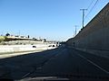
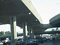
Entering Interstate 110 in Harbor Gateway, Los Angeles
-
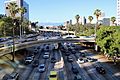
The Harbor Freeway is often heavily congested at rush hour.
-
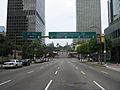
Entrance to the Harbor Freeway in Downtown Los Angeles
-
The Harbor Freeway southbound entering "The Slot" after emerging from the "4-level"
-
Carpool lanes on the upper deck of the Harbor Freeway, south of Adams Boulevard
-
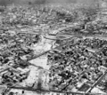
I-10 under construction (Near SR 11), c. 1960
-
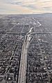
Aerial view from the north of the Harbor Freeway (I-110) and its Judge Harry Pregerson Interchange with the Century Freeway (I-105), on approach to Los Angeles International Airport. The Palos Verdes Peninsula and Santa Catalina Island are visible in the distance.
.jpg)


See also
 In Spanish: Interestatal 110 y Ruta Estatal 110 para niños
