
San Pedro, Los Angeles facts for kids
Quick facts for kids
San Pedro
|
|
|---|---|
.jpg)
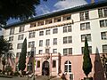
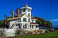
The historic Harbor View House
|
|

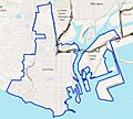
Boundaries of San Pedro as drawn by the Los Angeles Times
|
|

San Pedro, Los Angeles
Location in Southern Los Angeles
|
|
| Country | United States |
| State | California |
| County | Los Angeles |
| City | Los Angeles |
| Named for | Pope Peter I of Alexandria |
| Elevation | 112 ft (34 m) |
| Population
(2022)
|
|
| • Total | 83,556 |
| Time zone | UTC−8 (PST) |
| • Summer (DST) | UTC−7 (PDT) |
| ZIP code |
ZIP Codes 90731-90734
|
| Area code(s) | 310/424 |
| GNIS feature ID | 1661392 |
San Pedro is a neighborhood in Los Angeles, California. It is part of the South Bay and Harbor area. San Pedro used to be its own city. It joined Los Angeles in 1909. The Port of Los Angeles, a very important international seaport, is partly located here. San Pedro has grown from a fishing town to a busy and diverse community.
Contents
History of San Pedro
Early People and Explorers

For thousands of years, the Tongva people lived on the peninsula where San Pedro is now. They had villages like Chowigna and Suangna. The Tongva used special plank canoes called te'aats to travel along the coast and to nearby islands. These boats are still important to the Tongva culture today.
The first Europeans arrived in 1542. This was Juan Rodríguez Cabrillo, a Spanish explorer. He saw many plank boats used by the Chumash, who were neighbors of the Tongva.
How San Pedro Got Its Name

San Pedro was named after Saint Peter of Alexandria. His feast day is November 24. This was the day in 1542 when Juan Rodríguez Cabrillo first saw San Pedro Bay. The next day, November 25, Santa Catalina Island was named after Saint Catherine of Alexandria.
Later, in 1602–1603, Sebastián Vizcaíno officially mapped the California coastline for Spain. This included San Pedro Bay. The name "San Pedro" is pronounced "san-PEE-dro" in English.
European Settlement and Growth

European settlement in San Pedro began in 1769. This was part of Spain's plan to settle California. In 1784, the Spanish King gave a large piece of land, over 75,000 acres (300 km2), to Juan José Domínguez. This land was called Rancho San Pedro. It was the first land grant in California.
When Mexico became independent from Spain, trade rules changed. San Pedro began to grow. After the Mexican–American War in 1848, the United States took control. The harbor was greatly improved by Phineas Banning and John G. Downey. In 1868, Banning built Southern California's first railroad, the Los Angeles & San Pedro Railroad. This railroad moved goods from San Pedro Bay to Los Angeles.
.jpg)
In 1906, the city of Los Angeles added the Harbor Gateway. This was a narrow strip of land that connected Los Angeles to Wilmington. In 1909, Los Angeles joined with both Wilmington and San Pedro.
In 1929, an earthquake caused a part of a cliff to slide into the sea. This event is known as the Sunken City Disaster.

From 1919 to 1940, San Pedro was an important home port for the United States Navy's Battle Fleet. In 1914, Fort MacArthur was built near the bay. It was a coastal defense site for many years.
In 1919, many Navy ships moved from the Atlantic to the Pacific Ocean. San Pedro Bay was deep enough for large ships like battleships. The good weather also allowed for frequent training exercises. By 1934, many battleships, aircraft carriers, and other ships were based in San Pedro.
In 1940, the battleships moved to Hawaii. They stayed there to help prevent Japanese aggression. Even though the main fleet left, San Pedro remained important during World War II. It had a supply depot, fuel depot, and training schools. Shipbuilders in San Pedro also built many ships for the war effort.
Today, the battleship USS Iowa (BB-61) is a museum ship in San Pedro. It helps people learn about the ship's history. The SS Lane Victory, a World War II cargo ship, is also a museum ship here.
Geography and Weather
San Pedro's Location

San Pedro is bordered by several other areas. To the north are Harbor City and Torrance. To the east are Wilmington and Long Beach. The Pacific Ocean is to the south. To the west are Rancho Palos Verdes and Lomita.
| Climate data for San Pedro, Los Angeles | |||||||||||||
|---|---|---|---|---|---|---|---|---|---|---|---|---|---|
| Month | Jan | Feb | Mar | Apr | May | Jun | Jul | Aug | Sep | Oct | Nov | Dec | Year |
| Mean daily maximum °F (°C) | 67 (19) |
68 (20) |
68 (20) |
71 (22) |
73 (23) |
76 (24) |
81 (27) |
82 (28) |
80 (27) |
77 (25) |
72 (22) |
67 (19) |
73 (23) |
| Mean daily minimum °F (°C) | 46 (8) |
48 (9) |
50 (10) |
52 (11) |
56 (13) |
59 (15) |
62 (17) |
63 (17) |
62 (17) |
57 (14) |
50 (10) |
46 (8) |
54 (12) |
| Average precipitation inches (mm) | 3.31 (84) |
3.12 (79) |
2.69 (68) |
0.70 (18) |
0.27 (6.9) |
0.08 (2.0) |
0.03 (0.76) |
0.13 (3.3) |
0.25 (6.4) |
0.43 (11) |
1.17 (30) |
1.85 (47) |
14.02 (356) |
Places to Visit in San Pedro

.jpg)
.jpg)
San Pedro is home to the Port of Los Angeles. The Vincent Thomas Bridge is a long suspension bridge. It connects San Pedro with Terminal Island.
You can visit the Battleship Iowa museum. There is also the Los Angeles Maritime Museum, which is the largest maritime museum in California. The museum ship SS Lane Victory is another interesting place to see.
Warehouse 1, built in 1917, was once the largest warehouse west of Chicago. It is now a California State Historical Landmark. Another historic naval warehouse is home to Crafted at the Port of Los Angeles. This is a permanent craft market.
The Cabrillo Marine Aquarium was designed by Frank Gehry. It started in the old Bath House at Cabrillo Beach. The Point Fermin Light is a Victorian-era lighthouse. It is now a museum and park with ocean views. The Korean Bell of Friendship is a huge bronze bell. It was given by South Korea to Los Angeles in 1976. The Mary Star of the Sea church is a well-known building. It has a statue on its steeple overlooking the harbor.
People of San Pedro
Community and Culture
San Pedro has always been a place where people from many different countries came to live. This mix of cultures is seen in the many restaurants. You can find Croatian, Portuguese, Mexican, Italian, Irish, and Greek food.
San Pedro has the largest Italian-American community in Southern California. This community is centered on "Via Italia" (South Cabrillo Avenue). It is also a main hub for Croatian and Norwegian communities in Los Angeles. Many Croatian people came from the Dalmatia region. They were often sailors and fishermen. The city of Los Angeles even named a street "Croatian Place" to honor this community. You can also find the Norwegian Seamen's Church here.
Before 1942, a lively Japanese community lived on Terminal Island (East San Pedro). These Japanese immigrants were important in starting the fishing industry in San Pedro. They were pioneers in fishing for albacore and harvesting abalone. During World War II, these residents were moved away from their homes.
Getting Around San Pedro
Roads and Public Transport

Interstate 110 starts in San Pedro. It goes north for 20 miles to Downtown Los Angeles. California State Route 47 goes west from San Pedro. It crosses the Vincent Thomas Bridge and connects San Pedro to Terminal Island and Wilmington.
The LA Metro Bus 205 line travels north from San Pedro. The LADOT DASH San Pedro line travels up and down Western Avenue. There is also a Commuter Express bus that goes to Downtown Long Beach.
LA Metro J Line
|
Downtown San Pedro
|
|||||||||||
|---|---|---|---|---|---|---|---|---|---|---|---|
| Services | |||||||||||
|
|||||||||||
The J Line of the Los Angeles Metro Busway ends in downtown San Pedro. This bus line goes north to Downtown Los Angeles. It follows the Harbor Freeway (I-110). It then goes east along the San Bernardino Freeway (I-10) to El Monte.
In San Pedro, the J Line stops at several places. These include Beacon Street at 1st Street, and Pacific Avenue at 1st, 3rd, 7th, 11th, 15th, 17th, 19th (southbound only), and 21st Streets.
Ports and Shipping
.jpg)
.jpg)
The Port of Los Angeles is in San Pedro Bay. Together with the Port of Long Beach, it is called "America's Port." It is one of the busiest ports in the Western Hemisphere. The port has 25 cargo terminals and 82 container cranes. It covers 7,500 acres (3,000 ha) of land and water. Its main trading partners are China, Japan, and Vietnam.
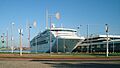
The World Cruise Center offers cruises along the Pacific Coast. You can also take a ferry to Catalina Island from here.
Education in San Pedro
Schools for Kids and Teens
San Pedro is part of the Los Angeles Unified School District. This district manages many schools in the area.
San Pedro High School, Mary Star of the Sea High School, and the Port of Los Angeles High School are the main high schools. San Pedro High School is over 100 years old. It has special programs like Marine Science and Police Academy. Port of Los Angeles High School is a public charter school. It teaches about international business and maritime studies.
Sometimes, students from San Pedro can go to schools in the Palos Verdes Peninsula Unified School District. This can happen if a parent is in the military or works in the Palos Verdes Peninsula. It can also happen if a grandparent lives there, or if the school is closer to the student's home.
- Primary Schools (Grades 1–5)
- 15th Street Elementary
- Bandini Elementary
- Barton Hill Elementary
- Cabrillo Elementary
- Leland Elementary
- Park Western Harbor Magnet
- Point Fermin Marine Science Magnet
- South Shores Magnet for the Visual and Performing Arts Elementary School
- Taper Elementary
- Taper Avenue Elementary Technology Magnet Center
- White Point Elementary
- Crestwood Elementary
- 7th Street Elementary
- Secondary Schools (Grades 6–12)
- Dana Middle School
- Dodson Middle School (part of LAUSD, but in Rancho Palos Verdes)
- San Pedro High School
- San Pedro High School Marine Science Magnet
- San Pedro High School Police Academy
- Port of Los Angeles High School
- Baxter High School
- Private Schools
- Holy Trinity School (Preschool–8)
- Christ Lutheran Church and School (Preschool–8)
- Mary Star of the Sea Elementary School (Grades 1–8)
- Rolling Hills Estates Preparatory School (Grades 6–12)
- Mary Star of the Sea High School (Grades 9–12)
Libraries in San Pedro
The Los Angeles Public Library has the San Pedro Regional Branch Library. It is located at 931 South Gaffey Street.
Events and Recognition
San Pedro hosts the annual "Shakespeare by the Sea, Los Angeles" Festival. This event is held at Point Fermin Park every summer.
In 2017, Curbed Los Angeles named San Pedro the "Neighborhood of the Year."
Notable People from San Pedro
Images for kids
-
The historic Harbor View House
-
Boundaries of San Pedro
-
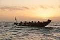
The Tongva used te'aats to navigate the coastline.
-
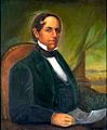
Don Manuel Domínguez helped start the settlement at San Pedro.
-
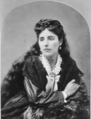
Rudecinda Sepúlveda de Dodson, a pioneer of San Pedro.
-

An 1859 map of Rancho San Pedro.
-
USS Nevada in San Pedro, 1934.
-
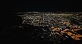
San Pedro is in the center and right foreground of this night aerial photo of Los Angeles.
-
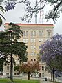
San Pedro Municipal Building, built in 1928.
-

Cabrillo Beach Bathhouse.
-
Point Fermin Light
-

A cyclist on Beacon Street around 1907.
-
The Sea Princess in Port of LA.
-
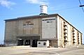
Historic Warehouse No. 1, built in 1917.
See also
 In Spanish: San Pedro (Los Ángeles) para niños
